Gulf of Khambhat
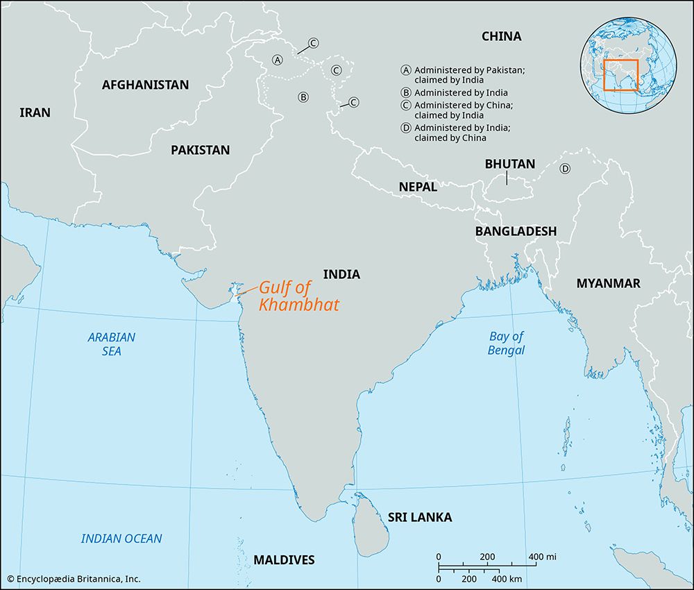
The Gulf of Khambhat is a trumpet-shaped gulf of the Arabian Sea that indents the coast of Gujarat, India. Its unique physical characteristics are defined by…
What are the unique geological features of the Gulf of Khambhat?
The Gulf of Khambhat is a trumpet-shaped gulf of the Arabian Sea that indents the coast of Gujarat, India. Its unique physical characteristics are defined by its dramatic narrowing and extreme tidal activity:1
- Shape and Geography: The gulf spans 120 miles (190 km) at its mouth between Diu and Daman, but it narrows rapidly to just 15 miles (24 km) at its head.1
- Tidal Dynamics: Due to its specific shape and orientation relative to the southwest monsoon winds, the gulf experiences a high tidal range of up to 40 feet (12 meters) and high-velocity tidal currents.1
- Sedimentation: The gulf receives significant inflow from several rivers, including the Sabarmati, Mahi, Narmada, and Tapti. The combination of these flood torrents and powerful tides results in heavy silting, creating treacherous shoals and sandbanks that complicate navigation.1
- Resource Potential: The region is geologically significant for its energy resources, with notable oil exploration occurring near Bharuch and the offshore Mumbai High field.1
What are the major rivers that flow into the Gulf of Khambhat?
The Gulf of Khambhat receives water from several major rivers that contribute to its significant sedimentation and shallowing. These primary rivers include:
- Sabarmati River: One of the key rivers flowing into the gulf.1
- Mahi River: This river enters the sea via a wide estuary past the town of Khambhat. The silt it carries has been a major factor in the shallowing of the gulf and the decline of its historical ports.14
- Narmada River: A major river that flows westward, roughly parallel to the Tapti, before reaching the gulf.15
- Tapti River: This river flows through the plain of Surat before emptying into the Gulf of Khambhat. Its mouth has historically been subject to heavy silting, which affected the viability of local ports like Swally Hole.15
The interaction between these flood-prone rivers and the gulf’s powerful tidal currents creates a challenging environment for navigation due to the resulting shoals and sandbanks.1
How has the Gulf of Khambhat’s ecosystem been affected by human activities and climate change?
What is the geographical location and extent of the Gulf of Khambhat?
The Gulf of Khambhat, also known as the Gulf of Cambay, is a trumpet-shaped inlet of the Arabian Sea located along the coast of Gujarat state in western India.12
Geographically, the gulf is situated between Mumbai and the Kathiawar Peninsula. Its physical extent is characterized by a significant narrowing: while the mouth of the gulf measures 120 miles (190 km) wide between Diu and Daman, it rapidly tapers to a width of just 15 miles (24 km). The town of Khambhat is positioned at the head of the gulf.1
The region is noted for its extreme tidal activity, with a tidal range reaching up to 40 feet (12 meters), which, combined with heavy riverine silt, creates challenging conditions for navigation.1
Sources
- Gulf of Khambhat — Encyclopædia Britannica
- Khambhat, Gulf of — Merriam-Webster
- Persian Gulf - Hydrology — Encyclopædia Britannica
- Tapti River — Encyclopædia Britannica
- Mahi River — Encyclopædia Britannica
Published on · 2 min read