Hamgyŏng Mountains
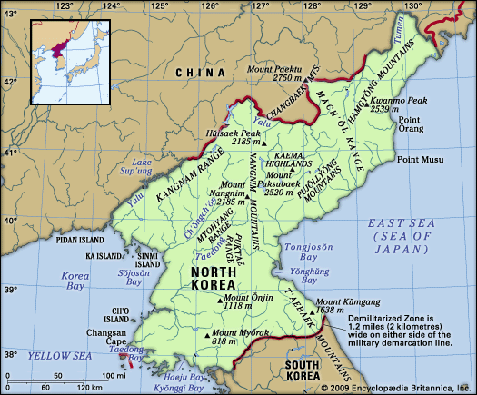
The Hamgyŏng Mountains are a prominent mountain range located in northeastern North Korea. Often referred to as the "Korean Alps," this range serves as a…
What is Hamgyŏng Mountains?
The Hamgyŏng Mountains are a prominent mountain range located in northeastern North Korea. Often referred to as the “Korean Alps,” this range serves as a critical watershed, separating the northern frontier near the Chinese border from the coastal region along the Sea of Japan.1
Situated on the northeastern edge of the Kaema Highlands, the range stretches from the Tumen River in the northeast to the Pujŏllyŏng Mountains in the southwest. It is the highest range in Korea, featuring 72 peaks that exceed 6,600 feet (2,000 meters). The highest point is Kwanmo Peak, reaching 8,333 feet (2,540 meters), surpassed in the Korean peninsula only by Mount Paektu. The region is characterized by an abundance of virgin forests and a steep eastern incline, which results in short, swift rivers flowing toward the sea.1
What are the Kaema Highlands?
The Kaema Highlands are a vast tableland located in northern North Korea, often referred to as the “roof of the Korean Peninsula.” Covering approximately 15,500 square miles (40,000 square km), the region features elevations ranging from 3,300 to 6,600 feet (1,000 to 2,000 meters).21
The highlands are bounded by several significant geographical features:
- North: Mount Paektu, an extinct volcano and the highest point on the peninsula.21
- West: The Nangnim Mountains.2
- East: The coast of the Sea of Japan (East Sea).2
- South: The northern tip of the T’aebaek Mountains.2
The area is characterized by abundant forest resources and traditional agricultural practices, such as burning fields to cultivate crops like millet, beans, oats, and potatoes. The Hamgyŏng Mountains extend along the northeastern edge of the highlands, creating a steep transition toward the eastern coast.231
Why are the Hamgyong Mountains called the Korean Alps?
The Hamgyŏng Mountains are referred to as the “Korean Alps” primarily because they constitute the highest mountain range in Korea.1
This designation reflects the range’s impressive topography, which features 72 peaks rising above 6,600 feet (2,000 meters). Among these, Kwanmo Peak reaches an elevation of 8,333 feet (2,540 meters), making it the second-highest point on the Korean Peninsula, surpassed only by Mount Paektu. The range is further characterized by its rugged, steep eastern incline and an abundance of virgin forests, which contribute to its dramatic, alpine-like landscape.1
What is the significance of the Tumen River?
The Tumen River holds significant geopolitical and economic importance as it forms the northeastern frontier between North Korea, China, and Russia. Originating at Mount Paektu, the highest peak of the Changbai Mountains, the river flows 324 miles (521 km) to the Sea of Japan.
Its significance is rooted in several key factors:
- Industrial Resources: The river basin is a vital hub for mining. The upstream region near Musan is rich in iron, while the middle course contains significant deposits of brown coal. The downstream area is considered the country’s premier district for mineral resources.
- Geopolitical Connectivity: The river serves as a strategic border zone. Near its mouth, the city of Sŏnbong (Unggi) provides a critical transportation link, connecting North Korea to the Russian rail network at Kraskino.
- Geography: As the third-longest river in Korea, it flows through rugged, heavily forested terrain, shaping the physical landscape of the northeastern border region.
Sources
- Hamgyŏng Mountains — Encyclopædia Britannica
- Kaema Highlands — Encyclopædia Britannica
- North Korea - Relief — Encyclopædia Britannica
- Tumen River — Encyclopædia Britannica
Published on · 2 min read