Kaema Highlands
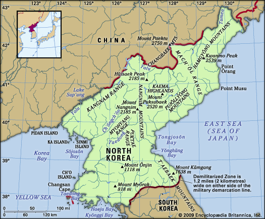
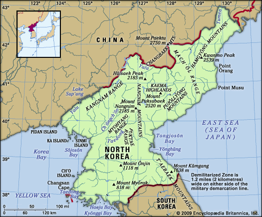
The Kaema Highlands are a vast tableland located in northern North Korea. Often referred to as the "roof of the Korean Peninsula," this region covers…
What is Kaema Highlands?
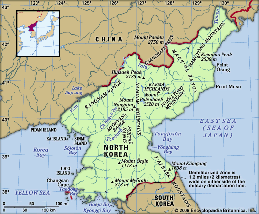
The Kaema Highlands are a vast tableland located in northern North Korea. Often referred to as the “roof of the Korean Peninsula,” this region covers approximately 15,500 square miles (40,000 square km) with elevations ranging between 3,300 and 6,600 feet (1,000–2,000 meters).1
The plateau is geographically defined by several landmarks:
- North: Paektu Mountain1
- West: Nangnim Mountain Range1
- East: The coast of the Sea of Japan (East Sea)1
- South: The northern tip of the T’aebaek Mountains1
The area is characterized by its abundant forest resources. Local agriculture relies on traditional field-burning methods to cultivate crops such as millet, beans, oats, and potatoes.1
What is the significance of Mount Paektu?
Mount Paektu holds significant status as the highest peak on the Korean Peninsula, reaching an elevation of 9,022 feet (2,750 meters). Located at the northern edge of the Kaema Highlands within the Changbai Mountains, it serves as a prominent natural landmark along the border between North Korea and China.2
Geologically, the mountain is an extinct volcano distinguished by a large crater lake at its summit. Its height and position make it a defining feature of the region’s topography.2
How does the climate affect agriculture in the highlands?
The climate of the Kaema Highlands significantly constrains agricultural activity due to its harsh, cool continental conditions. The region experiences a short growing season, with fewer than 120 frost-free days annually, which is considerably shorter than the 200 days found along the coast. Furthermore, the northern inland plateau receives limited annual precipitation, averaging only about 24 inches (610 mm).1
These environmental challenges dictate the agricultural practices of the area. Because the climate is not conducive to more sensitive crops, farmers rely on the cultivation of hardy staples such as millet, beans, oats, and potatoes. To manage the land effectively under these conditions, agriculture in the highlands is characterized by the traditional burning of fields to prepare the soil for these specific crops.3
What kind of wildlife lives in the Kaema Highlands?
The Kaema Highlands are characterized by abundant forest resources, primarily consisting of coniferous trees such as Siberian fir, spruce, pine, and Korean pine (Pinus koraiensis).4
Due to significant deforestation, the populations of many larger mammals have greatly decreased and are now restricted to the region’s more remote forests. These animals include:
- Deer
- Mountain antelope
- Goats
- Tigers
- Leopards4
While these species were once more widespread, their presence is now limited by the loss of habitat. The highlands’ rugged terrain and dense coniferous cover provide the remaining sanctuary for these populations.4
Sources
- Kaema Highlands — Encyclopædia Britannica
- North Korea - Relief — Encyclopædia Britannica
- North Korea - Climate — Encyclopædia Britannica
- Kyrgyzstan - Plant and animal life — Encyclopædia Britannica
- North Korea - Plant and animal life — Encyclopædia Britannica
- South Korea - Plant and animal life — Encyclopædia Britannica
Published on · 2 min read