Nangnim Mountains
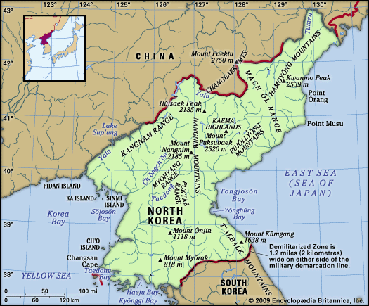
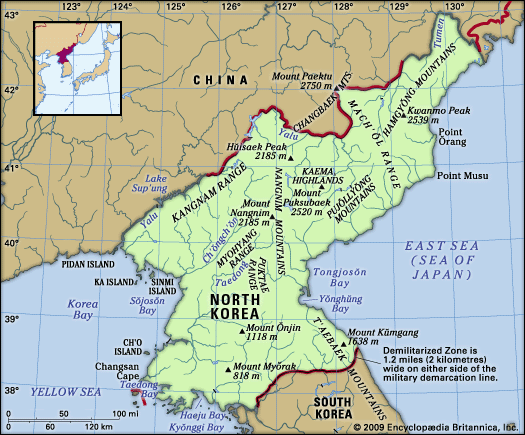
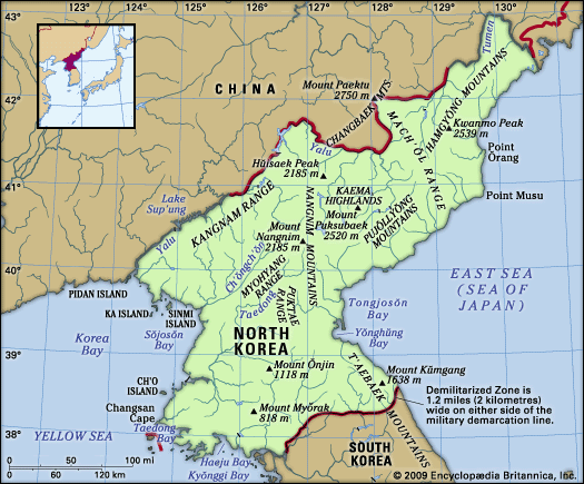
The Nangnim Mountains are a mountain range located in central North Korea, situated to the west of the Kaema Highlands.
What is Nangnim Mountains?
The Nangnim Mountains are a mountain range located in central North Korea, situated to the west of the Kaema Highlands.1
The range serves as a significant watershed, dividing the northeastern region of the Korean Peninsula (Kwanbuk) from the northwestern region (Kwansŏ). The mountains feature several prominent peaks, including Mount Sobaek (9,003 feet), Mount Maengba (7,421 feet), Mount Nangnim (7,165 feet), and Mount Paek (6,152 feet), with an average elevation of approximately 5,000 feet.1
Additionally, the range acts as the source for the Taedong and Ch’ŏngch’ŏn rivers, which flow southwest toward the Yellow Sea. While the rugged terrain historically obstructed natural trade routes between the surrounding regions, modern infrastructure, including roads and railways, now connects these areas.1
What are the Kaema Highlands?
The Kaema Highlands are a vast tableland located in northeastern North Korea. Often referred to as the “roof of the Korean Peninsula,” this plateau covers approximately 15,500 square miles (40,000 square km) with elevations typically ranging between 3,300 and 6,600 feet (1,000–2,000 meters).23
The region is defined by its rugged borders:
- North: Mount Paektu, an extinct volcano and the highest peak on the peninsula, sits at the northern edge.23
- West: The Nangnim Mountains.2
- East: The coast of the Sea of Japan (East Sea), separated from the highlands by the steep Hamgyŏng Mountains.23
- South: The northern reaches of the T’aebaek Mountains.2
The highlands are rich in forest resources, and local agriculture relies on traditional field-burning methods to cultivate crops such as millet, beans, oats, and potatoes.2
How do mountain ranges affect climate in North Korea?
Mountain ranges play a critical role in shaping the climate of North Korea by acting as physical barriers to air masses and influencing regional temperature and precipitation patterns.41
- Temperature Regulation: The mountains bordering the narrow coastal lowlands help moderate temperatures. Notably, winter temperatures on the east coast are 5 to 7 °F (3 to 4 °C) higher than those on the west coast due to the influence of these ranges and ocean currents.4
- Precipitation Patterns: Mountains significantly influence rainfall distribution. While the country generally receives about 40 inches of precipitation annually, the northern inland plateau receives only about 24 inches, whereas areas like the upper Ch’ŏngch’ŏn River basin receive significantly more. High-altitude regions, such as the T’aebaek Mountains, experience locally heavy snowfall.4
- Growing Seasons: Elevation dictates the length of the frost-free season. Coastal areas enjoy about 200 frost-free days, while the high-altitude Kaema Highlands have fewer than 120, reflecting the cooling effect of higher elevations.4
Which major rivers originate in the Nangnim Mountains?
The Nangnim Mountains serve as a significant watershed in central North Korea. Two major rivers originate within this range:
- Taedong River: Rising in the Nangnim Mountains in Hamgyŏng-nam province, this river flows 273 miles (439 km) southwestward to the Yellow Sea. It is a vital waterway for transportation and irrigation, serving major cities such as P’yŏngyang along its course.17
- Ch’ŏngch’ŏn River: This river also originates in the Nangnim Mountains. It flows southwestward between the mountain spurs toward the Yellow Sea, following a path similar to the Taedong.1
Sources
- Nangnim Mountains — Encyclopædia Britannica
- Kaema Highlands — Encyclopædia Britannica
- North Korea - Relief — Encyclopædia Britannica
- North Korea - Climate — Encyclopædia Britannica
- South Korea - Climate — Encyclopædia Britannica
- Highland climate — Encyclopædia Britannica
- Taedong River — Encyclopædia Britannica
- Jilin - Drainage — Encyclopædia Britannica
Published on · 2 min read