Henry Mountains
The Henry Mountains are a mountain range located on the Colorado Plateau in southern Utah, U.S., stretching approximately 40 miles (64 km). The range is…
What is Henry Mountains?
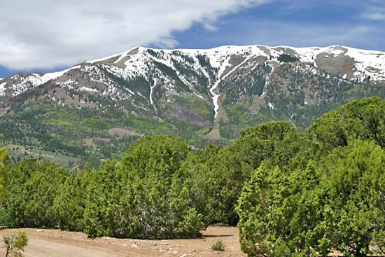
The Henry Mountains are a mountain range located on the Colorado Plateau in southern Utah, U.S., stretching approximately 40 miles (64 km). The range is named after Joseph Henry, the first secretary of the Smithsonian Institution, and its highest peak is Mount Ellen, reaching 11,615 feet (3,540 metres).1
Geologically, the mountains are significant as a classic example of laccolith formations, where igneous lava has caused an uplift in the crust. The range is also historically important to the field of geology; Grove Karl Gilbert’s 1877 report on the area provided a foundational analysis of fluvial processes and the concept of dynamic equilibrium in landscapes.12
Today, the region includes parts of the Glen Canyon National Recreation Area and supports wildlife, including a herd of bison introduced in 1941 and a population of sage grouse.1
What is a laccolith and how does it form?
A laccolith is a type of igneous intrusion that forms when magma forces its way between layers of existing rock, known as strata.34
Formation and Structure
Laccoliths form through a specific process of crustal displacement:
- Intrusion: Magma rises from a source below and pushes into the space between sedimentary rock layers.35
- Domed Shape: Unlike a sill, which is a sheetlike intrusion that remains parallel to the surrounding rock, a laccolith causes the overlying strata to bulge upward, creating a characteristic mushroom or dome-shaped structure with a relatively flat floor.34
- Dimensions: These bodies are typically smaller than stocks and are defined by a diameter-to-thickness ratio of less than 10.3
The Henry Mountains in Utah serve as the classic geological site where these formations were first described. They are generally composed of acidic or intermediate silica rocks.34
Who was Grove Karl Gilbert and why is his work important?
Grove Karl Gilbert (1843–1918) was a prominent U.S. geologist and a foundational figure in modern geomorphology, the study of landforms.6
His work is considered essential for several key contributions:
- Dynamic Equilibrium: Gilbert introduced the concept that landforms exist in a state of balance between the forces acting upon them (such as flowing water) and the resistance of the underlying rock. This idea of dynamic equilibrium remains a cornerstone of geomorphic theory.62
- Fluvial Analysis: In his influential Report on the Geology of the Henry Mountains (1877), he provided a detailed analysis of how streams erode and shape the landscape, explaining how they reach a “graded” condition where erosion and deposition are balanced.62
- Geological Discovery: He was the first to describe the laccolith, an igneous intrusion that domes overlying rock layers. Additionally, his work on Lake Bonneville—the ancestor of the Great Salt Lake—and the Niagara River are considered landmark studies.6
- Institutional Impact: As a senior geologist with the U.S. Geological Survey, he helped establish the standards for geological mapping, nomenclature, and cartography still used today.6
What are some other unique geological features of the Colorado Plateau?
The Colorado Plateau is a diverse physiographic province defined by its high elevation and distinct erosional patterns. Beyond its famous deep canyons, the region features several unique geological formations:
- Mesas, Buttes, and Spires: The headward erosion of streams into the plateau surface isolates sections of rock, creating iconic landforms such as mesas, buttes, and towering spires.7
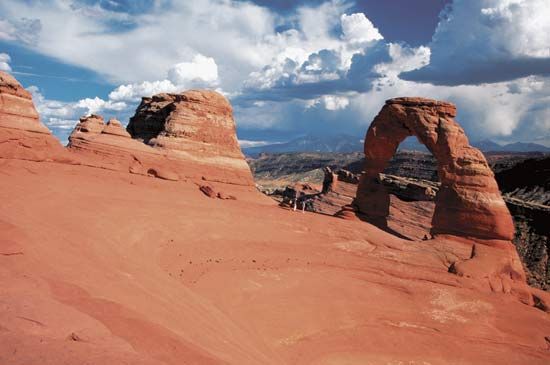
- Natural Arches and Fins: In areas like Arches National Park, bedrock fractured into parallel joints weathers into thin walls called “fins.” Further weathering of these fins creates natural arches and windows.8
- Cliff-and-Bench Topography: Because the plateau consists of alternating layers of weak rock (like shale) and resistant rock (like limestone), the landscape naturally erodes into a distinct “cliff-and-bench” pattern.9
- Volcanic Features: The southeastern Datil section is distinguished by volcanic activity, including lava flows and volcanic necks.7
- Laccolithic Mountains: Groups such as the Henry Mountains and La Sal Mountains are formed by laccoliths—magma injected between sedimentary layers that causes the surface to bulge into domes.9
Sources
- Henry Mountains — Encyclopædia Britannica
- Earth sciences - Concepts of landform evolution — Encyclopædia Britannica
- laccolith — Encyclopædia Britannica
- igneous rock - Intrusive igneous rocks — Encyclopædia Britannica
- laccolith — Merriam-Webster
- Grove Karl Gilbert — Encyclopædia Britannica
- Colorado Plateau — Encyclopædia Britannica
- Arches National Park — Encyclopædia Britannica
- Rocky Mountains - Physiography — Encyclopædia Britannica
Published on · 3 min read