Jayawijaya Mountains
The Jayawijaya Mountains form the eastern section of the Maoke Mountains, which are part of the central highlands on the island of New Guinea. Located within…
What is Jayawijaya Mountains?
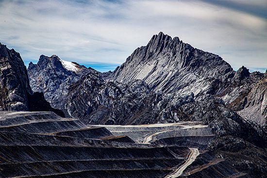
The Jayawijaya Mountains form the eastern section of the Maoke Mountains, which are part of the central highlands on the island of New Guinea. Located within the Indonesian province of Papua, this range stretches approximately 230 miles (370 km) from the Sudirman Range in the west to the Star Mountains and the border of Papua New Guinea in the east.12
The terrain is rugged, with a tree line situated at about 12,000 feet (3,660 metres). The highest point of the Jayawijaya range is Trikora Peak, which reaches an elevation of 15,580 feet (4,750 metres). While the Jayawijaya Mountains are a major component of the central highlands, the highest peak on the entire island of New Guinea is actually found in the adjacent Sudirman Range, known as Jaya Peak.21
What is the significance of Puncak Jaya?
Puncak Jaya, also known as Jaya Peak or formerly as Mount Carstensz, holds significant geographical status as the highest mountain on the island of New Guinea and the highest island peak in the world. Located in the Sudirman Range within the Indonesian province of Central Papua, its summit reaches an elevation of 16,024 feet (4,884 meters), making it the highest point in the southwestern Pacific.342
The peak is also a critical indicator of environmental change. While it was historically capped by glaciers, climate change has caused more than 99 percent of its ice to melt by 2025. Historically, the mountain was a notable challenge for explorers; although the snowfield was reached in 1909, the summit remained unclimbed until 1962, when an expedition led by the Austrian mountaineer Heinrich Harrer successfully reached the top.35
How do the Maoke Mountains shape New Guinea’s geography?
The Maoke Mountains serve as the primary structural backbone of New Guinea, forming the western segment of the island’s central highlands. Stretching 430 miles (692 km) across the Indonesian province of Papua, this rugged range acts as a significant topographical barrier that defines the island’s interior landscape.2
The range is divided into two distinct sections:
- Sudirman Range (West): This section contains the island’s highest elevation, Jaya Peak, which reaches 16,024 feet (4,884 metres).2
- Jayawijaya Mountains (East): Extending 230 miles (370 km) toward the border of Papua New Guinea, this section includes Trikora Peak, which rises to 15,580 feet (4,750 metres).21
Much of the Maoke range remains above 12,000 feet (3,660 metres), which marks the approximate tree line for the region. Furthermore, several peaks exceed the snow line of 14,500 feet (4,400 metres), creating a high-altitude environment that contrasts sharply with the surrounding tropical lowlands.2
What is the climate like above the snow line?
The climate above the snow line is defined by the lower topographic limit where the accumulation of snow and ice persists throughout the year, as the rate of snowfall exceeds the rate of ablation (melting and evaporation). While general characteristics of high-altitude environments include decreased temperature, pressure, and humidity, the specific climate above the snow line varies significantly by latitude.789
- Tropical Regions: These areas experience a unique “winter every night and spring every day” cycle. While temperatures are low, the lack of distinct seasons means that daily solar radiation can warm the surface significantly, even at high altitudes. However, at the extreme elevations where permanent snow patches exist, conditions are generally too harsh for vascular plants to survive.9
- Temperate Regions: These mountains exhibit strongly marked seasons. Above the snow line, temperatures often remain below freezing day and night during the winter. Ecological factors such as heavy snow accumulation and avalanching become dominant, and the environment is characterized by a lack of plant growth due to the extreme cold and the brevity of the growing season.9
Sources
- Jayawijaya Mountains — Encyclopædia Britannica
- Maoke Mountains — Encyclopædia Britannica
- Jaya Peak — Encyclopædia Britannica
- Puncak Jaya — Merriam-Webster
- Jaya Peak: Top Questions — Encyclopædia Britannica
- Maoke Mountains — Merriam-Webster
- Snow line — Encyclopædia Britannica
- Highland climate — Encyclopædia Britannica
- Mountain ecosystem - Environment — Encyclopædia Britannica
Published on · 3 min read