Katla
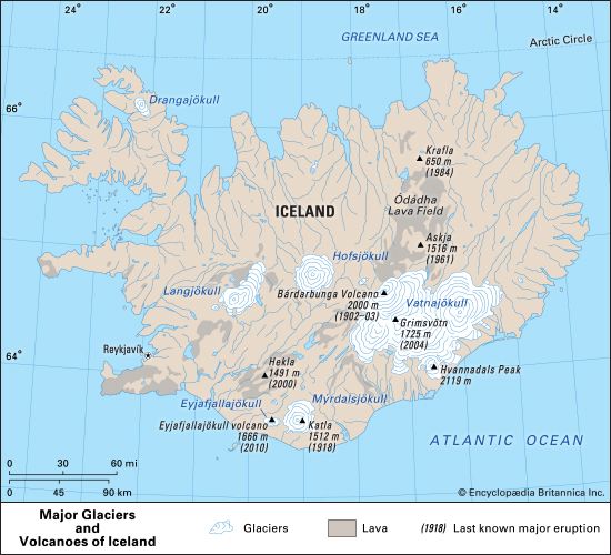
Katla is a subglacial volcano located in southern Iceland beneath the Mýrdalsjökull glacier. It features an oval caldera approximately 6 miles (10 km) wide…
What is the geological formation of Katla volcano and how does it differ from other volcanoes?
Katla is a subglacial volcano located in southern Iceland beneath the Mýrdalsjökull glacier. It features an oval caldera approximately 6 miles (10 km) wide at its summit.1
While Katla produces basaltic magma—which is typically low in viscosity and gas content, generally resulting in non-explosive activity—it differs from many other volcanoes due to its subglacial environment. When rising magma contacts the overlying glacier ice, the rapid vaporization of ice creates intense gas pressure. This interaction can trigger explosive eruptions of steam and ash, as well as massive lahars (volcanic mudflows) and glacier outburst floods that significantly alter the surrounding landscape.1
Where is Katla volcano located and what are its main geographical features?
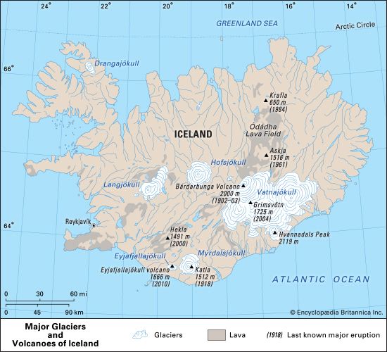
Katla is a highly active volcano situated in southern Iceland. It is located directly beneath the Mýrdalsjökull glacier, which covers an area of 268 square miles (695 square km) in the region.12
The volcano’s primary geographical features include:
- Summit Elevation: The summit reaches an altitude of 4,961 feet (1,512 meters) above sea level.1
- Caldera: It features a prominent oval-shaped caldera that measures approximately 6 miles (10 km) across at its widest point.1
- Glacial Setting: Because it is buried under the Mýrdalsjökull glacier, its eruptions often interact with ice, leading to the formation of steam, ash clouds, and significant glacier outburst floods.1
- Coastal Impact: Historical eruptions, such as the one in 1918, have generated massive lahars (volcanic mudflows) that have physically altered the southern coastline of Iceland.12
What is the historical significance of Katla volcano in Icelandic culture and mythology?
Sorry, the Britannica knowledge base does not contain information regarding the cultural or mythological significance of the Katla volcano. The available records focus on its geological activity, eruptive history, and physical impact on the Icelandic landscape.
How often does Katla erupt, and what are the potential consequences of a major eruption?
Katla is one of Iceland’s most active volcanoes, having erupted at least 20 times since 1100. While it typically produces basaltic magma—which is generally low in gas and viscosity—its subglacial location creates significant hazards. When rising magma contacts the overlying Mýrdalsjökull glacier, the rapid vaporization of ice can trigger explosive eruptions.1
The consequences of a major eruption can be severe:
- Explosive Ash Clouds: Eruptions can produce voluminous clouds of steam and ash, which may be dispersed over long distances, potentially disrupting air travel.1
- Glacier Outburst Floods: The melting of glacial ice often causes massive floods, known as jökulhlaups, which can damage infrastructure and farmland.12
- Lahars and Coastal Change: Tremendous lahars (volcanic mudflows) can occur; for instance, the 1918 eruption produced mudflows that physically extended Iceland’s southern coastline by approximately 3 miles (5 km).13
- Landslides: Explosive activity can trigger significant landslides in the surrounding terrain.1
Sources
- Katla — Encyclopædia Britannica
- Mýrdalsjökull — Encyclopædia Britannica
- Eyjafjallajökull volcano — Encyclopædia Britannica
Published on · 2 min read