Kwando River
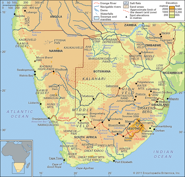
The Kwando River is located in southern Africa. It rises in central Angola and flows in a southeasterly direction, serving as the border between Angola and…
Where is the Kwando River located, and through which countries does it flow?
The Kwando River is located in southern Africa. It rises in central Angola and flows in a southeasterly direction, serving as the border between Angola and Zambia for approximately 140 miles1.
As it continues its course, the river reaches the northern boundary of the Caprivi Strip in Namibia. In this region, the river is also known as the Chobe or the Linyanti. It eventually spreads into the Linyanti Marshes before draining eastward toward the Zambezi River.1
What are the main geographical features and characteristics of the Kwando River?
The Kwando River is a significant waterway in southern Africa, characterized by the following features:
- Course and Length: The river rises in central Angola and flows southeast for a total length of 457 miles (731 km). For approximately 140 miles, it forms the boundary between Angola and Zambia.1
- Drainage Basin: The river’s drainage basin covers an area of 37,366 square miles (96,778 square km).1
- Marshes and Wetlands: Near the northern boundary of the Caprivi Strip, the river spreads into the Linyanti Marshes, which cover about 550 square miles (1,425 square km) and include Lake Liambezi. These marshes drain eastward toward the Zambezi River.1
- Regional Names: In its lower reaches, the river is known as the Chobe or the Linyanti.1
- Hydrology: The river experiences seasonal flooding, with water levels rising in May and reaching a high flood level in June at the northern Caprivi boundary. It is part of an extraordinary drainage system that brings water from the Angolan uplands into the northern Kalahari region.13
What is the historical significance of the Kwando River in the region?
The historical significance of the Kwando River is deeply tied to the Caprivi Strip, a region defined by its unique river systems. In the mid-19th century, the marshes surrounding the river—specifically at Linyanti—served as the capital for the chiefs of the Kololo people. This location was strategically important, as the Kololo kingdom acted as a base for the British explorer and missionary David Livingstone during his second and third expeditions into the African interior.1
Furthermore, the river system played a role in colonial geopolitics. The Caprivi Strip was incorporated into German South West Africa between 1884 and 1919. Britain ceded this territory to Germany specifically to provide the colony with riparian access to the Zambezi River, utilizing the Kwando–Linyanti–Chobe river system as a defining southern boundary for the strip.1
What role does the Kwando River play in transboundary water management between countries?
The Kwando River plays a critical role in regional geography by serving as a natural boundary and a vital component of the broader Zambezi River basin. Because the Kwando (also known as the Chobe or Linyanti) shares a floodplain with the Zambezi and eventually drains into it, its waters are integral to the transboundary hydrological systems of Angola, Zambia, Namibia, and Botswana.16
While the provided search results do not detail specific modern treaties governing the Kwando River itself, they note that the use of the Zambezi’s waters—which the Kwando feeds—has been the subject of numerous international agreements among the six countries within its basin. Historically, the river’s path was so significant for regional access that Britain ceded the Caprivi Strip to Germany specifically to grant the colony riparian access to the Zambezi system.56
Sources
- Kwando River — Encyclopædia Britannica
- Kwando — Merriam-Webster
- Zambezi River - Physiography — Encyclopædia Britannica
- Kalahari Desert - Drainage — Encyclopædia Britannica
- Caprivi Strip — Encyclopædia Britannica
- Zambezi River — Encyclopædia Britannica
- Zambia - Drainage — Encyclopædia Britannica
Published on · 3 min read