La Perouse Strait
La Perouse Strait is an international waterway located between the island of Sakhalin in Russia and the island of Hokkaido in Japan. It serves as a connector…
What is La Perouse Strait?
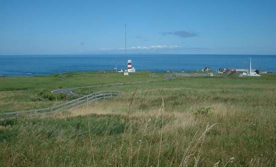
La Perouse Strait is an international waterway located between the island of Sakhalin in Russia and the island of Hokkaido in Japan. It serves as a connector between the Sea of Okhotsk and the Sea of Japan.1
The strait is named after the French explorer Jean-François de Galaup, Count de La Pérouse, who explored the region during his Pacific expedition in the late 18th century. At its narrowest point, between Cape Krilon on Sakhalin and Cape Sōya on Hokkaido, the strait is 27 miles (43 km) wide, with depths ranging from 167 to 387 feet (51 to 118 m). The area is known for its extremely strong marine currents and is typically closed by ice during the winter months.12
Who was Jean-François de Galaup, Count de La Pérouse?
Jean-François de Galaup, Count de La Pérouse (1741–c. 1788) was a distinguished French naval officer and navigator renowned for his extensive explorations of the Pacific Ocean during the 1780s.23
After a successful military career, including a campaign against British settlements in Hudson Bay during the American Revolution, he was commissioned by the French government to lead a major scientific and exploratory expedition to the Pacific, following in the footsteps of James Cook.2
Commanding the ships La Boussole and Astrolabe, he explored the coasts of Alaska, California, and East Asia, including the strait that now bears his name, La Perouse Strait. His expedition vanished after departing Botany Bay in 1788. Decades later, evidence confirmed that his ships were wrecked near Vanikolo in the Solomon Islands. His journals were published posthumously, providing a significant record of his global voyage.2
What are the characteristics of the Sea of Okhotsk?
The Sea of Okhotsk is a northwestern arm of the Pacific Ocean characterized by its cold climate, high biological productivity, and unique physical geography.
Physical Features
The sea is almost entirely enclosed by Russian territory, bounded by the Kamchatka Peninsula, the Kuril Islands, Hokkaido, and Sakhalin Island. It covers 611,000 square miles (1,583,000 square km) with a mean depth of 2,818 feet (859 meters). The seabed features a continental shelf in the north and west, while the deeper continental slope dominates the remaining area.4
Climate and Hydrology
Known as the coldest sea in East Asia, its northern and western regions experience a continental climate similar to the Arctic. Winters are severe, with extensive ice cover from October through June. Hydrologically, the sea receives water from the Sea of Japan and the Pacific, with a general counterclockwise water movement.4
Economic Importance
The sea is highly productive, supporting diverse marine life including salmon, herring, and various marine mammals. It is a vital region for commercial fishing and contains significant natural gas and oil deposits on its northern shelf.4
How do strong marine currents affect navigation in straits?
Strong marine currents significantly complicate navigation in straits and other confined waterways by creating challenging conditions that require precise vessel control. In areas like the North Sea, powerful tidal currents—often combined with shallow depths and shifting banks—increase the risk of accidents and make maritime transit treacherous.6
Navigators must account for these external forces to maintain a planned course. Because traditional dead reckoning relies on calculating a ship’s position based on its speed and heading, strong currents introduce drift that can lead to cumulative errors if not properly compensated for. Modern navigation mitigates these risks by integrating data from gyrocompasses, logs, and GPS into computers that use Kalman filtering to provide a more accurate estimate of a vessel’s true position and velocity.789
Furthermore, when a ship maneuvers in restricted waters, the interaction between its propulsion system and the surrounding water flow is critical. Operators must anticipate how lateral forces and cross-flows might affect the vessel’s heading, using the rudder or independent propeller thrust to counteract unwanted swinging or yawing motions.10
Sources
- La Perouse Strait — Encyclopædia Britannica
- Jean-François de Galaup, comte de La Pérouse — Encyclopædia Britannica
- La Pérouse — Merriam-Webster
- Sea of Okhotsk — Encyclopædia Britannica
- Tatar Strait — Encyclopædia Britannica
- ocean current - Distribution of ocean currents — Encyclopædia Britannica
- naval architecture - Effect of propulsion-device action on maneuverability — Encyclopædia Britannica
- navigation - Inertial guidance systems — Encyclopædia Britannica
- navigation - Dead reckoning by computer — Encyclopædia Britannica
- Why is the North Sea so dangerous? — Encyclopædia Britannica
Published on · 3 min read