Lake Waikaremoana
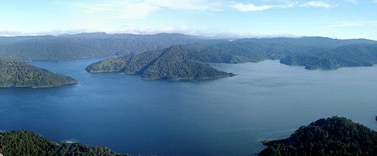
In the Māori language, the name Lake Waikaremoana translates to "sea of rippling water."
What is the meaning of the name ‘Waikaremoana’ in the Māori language?
In the Māori language, the name Lake Waikaremoana translates to “sea of rippling water.”1
What is the cultural significance of Lake Waikaremoana to the Māori people?
Lake Waikaremoana holds deep cultural significance as it remains the ancestral property of the indigenous Māori people, even though it is situated within the boundaries of Urewera National Park. The lake is a vital part of the Māori heritage, representing a connection to the land and water that has been maintained by the local iwi (tribes) throughout history.1
How does Lake Waikaremoana contribute to New Zealand’s hydroelectric power generation?
Lake Waikaremoana plays a significant role in New Zealand’s energy infrastructure by serving as a reservoir for downstream hydroelectric power stations.
The lake’s water is siphoned off to supply these facilities, a process that directly impacts the lake’s water levels. Because of this controlled drainage, the depth of the lake can fluctuate by as much as 45 feet (14 meters), depending on the volume of water diverted for power generation.1
How was Lake Waikaremoana formed, and what makes its formation unique?
Lake Waikaremoana was formed by a massive landslide that dammed the Waikare Taheke River. This event created a deep, expansive basin in the eastern North Island of New Zealand, which now reaches depths of up to 840 feet (256 meters).1
Its formation is distinct because, unlike many other lakes that may be formed by glacial activity or volcanic processes, Waikaremoana’s existence is defined by this specific landslide-damming event. Historically, the lake was drained by a combination of natural surface overflow and subsurface drainage. Today, it remains a significant natural feature within the region, with its water levels managed for hydroelectric power generation, causing the lake’s depth to fluctuate by as much as 45 feet (14 meters).1
Sources
- Lake Waikaremoana — Encyclopædia Britannica
- moano — Merriam-Webster
- Te Urewera — Encyclopædia Britannica
- glacial landform - Glaciolacustrine deposits — Encyclopædia Britannica
- lake - Basins formed by fluvial and marine processes — Encyclopædia Britannica
Published on · 1 min read