Limón Bay
Limón Bay is a natural harbour located in Panama at the northern terminus of the Panama Canal along the Caribbean Sea. Measuring approximately 4.5 miles long…
What is Limón Bay?
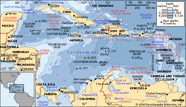
Limón Bay is a natural harbour located in Panama at the northern terminus of the Panama Canal along the Caribbean Sea. Measuring approximately 4.5 miles long and 2.5 miles wide, the bay is shielded from storms by artificial breakwaters.1
Functionally, the bay serves as a vital waiting area for vessels preparing to transit the canal. Its eastern shore is home to the twin cities of Colón and Cristóbal, the latter of which operates as a major port featuring extensive maritime servicing facilities. Because of these protected anchorages and its strategic location, the area remains a critical hub for international shipping.12
How does the Panama Canal work?
The Panama Canal functions as a sophisticated water-based elevator system that allows ships to bypass the long journey around South America by traversing the Continental Divide.34
The Lock System
The canal relies on a series of locks that use gravity to move vessels between sea level and the elevated Gatun Lake.54
- Lifting: Upon entering from the Atlantic or Pacific, ships are guided into lock chambers. Water is flooded into these chambers from the surrounding lakes, raising the vessel to the level of Gatun Lake (85 feet above sea level).54
- Transit: Once at the lake’s elevation, ships navigate the 23-mile channel through the lake and the Gaillard Cut, a gorge carved through the mountains.64
- Lowering: After crossing the isthmus, ships enter another set of locks that empty the water, gradually lowering the vessel back to sea level for its exit.34
Water Management
The system is powered by the Chagres River, which feeds Gatun and Alajuela lakes. These reservoirs provide the necessary water for the locks to operate via gravity flow. Recent expansions have introduced water-saving basins, which allow for a 60 percent reuse of water during each transit, significantly increasing the canal’s efficiency and capacity for larger “neo-Panamax” vessels.547
What is the history of the Panama Canal Zone?
The Canal Zone was a 10-mile-wide administrative territory in Panama under United States jurisdiction from 1904 to 1979. Established by the Hay–Bunau-Varilla Treaty of 1903, the zone granted the U.S. the right to construct, operate, and control the Panama Canal and the surrounding land.8
Throughout the 20th century, the zone was a site of significant geopolitical tension. While the U.S. maintained civil and military control, Panama sought greater sovereignty, leading to several renegotiations, such as the 1936 and 1955 treaties, which increased annuities and improved labor conditions for Panamanians. Growing friction over sovereignty and the display of the Panamanian flag eventually led to the landmark Torrijos-Carter Treaties in 1977.910
These treaties initiated the gradual phaseout of U.S. military bases and the transfer of administrative control. The Canal Zone was officially abolished on October 1, 1979, and on December 31, 1999, the Panama Canal Authority assumed full responsibility for the canal.811
Why are breakwaters important for harbors?
Breakwaters are essential artificial structures designed to protect harbors, anchorages, and marina basins by intercepting the energy of water waves. By absorbing or reflecting wave energy, they create a sheltered area of calm water, which is vital for the safety of vessels and the stability of port operations.12131415
Beyond providing shelter from severe weather and gales, breakwaters serve several critical engineering functions:
- Sediment Control: They can be strategically placed to reduce the silting of navigation channels, preventing the accumulation of debris that would otherwise require frequent dredging.16
- Current Diversion: Breakwaters and associated causeways are used to divert crosscurrents that might carry sediment or soft material into protected harbor areas.16
- Erosion Mitigation: By intercepting longshore currents, these structures can help prevent beach erosion, although they may shift the location of sedimentation elsewhere along the coast.12
Whether constructed as solid concrete or masonry walls, or as experimental floating platforms, the primary goal of a breakwater is to manage the destructive force of the sea while balancing construction costs with long-term maintenance requirements.141513
Sources
- Limón Bay — Encyclopædia Britannica
- Cristóbal — Encyclopædia Britannica
- Gatun Lake — Encyclopædia Britannica
- Panama Canal: Top Questions — Encyclopædia Britannica
- Panama Canal - Locks — Encyclopædia Britannica
- Timeline and Map of the Panama Canal — Encyclopædia Britannica
- Panama Canal - Capital improvements — Encyclopædia Britannica
- Canal Zone — Encyclopædia Britannica
- Panama Canal Treaty — Encyclopædia Britannica
- Panama Canal Treaty - The canal under U.S. control — Encyclopædia Britannica
- Panama Canal Treaty - The Torrijos-Carter Treaties — Encyclopædia Britannica
- Panama Canal - Breakwaters — Encyclopædia Britannica
- breakwater — Encyclopædia Britannica
- Harbors and sea works - Solid breakwaters — Encyclopædia Britannica
- Harbors and sea works - Floating breakwaters — Encyclopædia Britannica
- Harbors and sea works - Breakwaters — Encyclopædia Britannica
Published on · 3 min read