Lippe River
The Lippe River is a right-bank tributary of the Rhine located in the German state of North Rhine-Westphalia. It originates near Bad Lippspringe on the…
What is Lippe River?
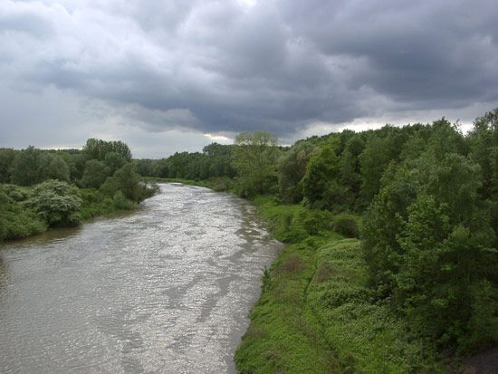
The Lippe River is a right-bank tributary of the Rhine located in the German state of North Rhine-Westphalia. It originates near Bad Lippspringe on the western edge of the Teutoburg Forest and flows westward for approximately 155 miles (250 km) before joining the Rhine near Wesel.12
The river serves as the northern boundary of the Ruhr industrial region. While it was historically significant for transporting coal, timber, and agricultural goods, much of this traffic shifted to a canal system between Hamm and the Rhine during the 20th century. Today, the river remains navigable downstream from Lippstadt for smaller vessels and provides essential water to the Ruhr’s canal network.1
It is important to distinguish the river from the former German state and principality of Lippe, which was situated between the Teutoburg Forest and the Weser River.2
What is the significance of the Rhine River in Europe?
The Rhine River is one of Europe’s most significant waterways, serving as a vital artery for both industrial transport and cultural history. Its importance is defined by several key roles:
Economic and Industrial Significance
- Commercial Artery: The Rhine is arguably the world’s most important industrial transport route. Since the 19th century, its ability to provide cheap water transport has made it a major axis for industrial production, with approximately one-fifth of the world’s chemical industries located along its banks.34
- International Waterway: Established as an international waterway by the Congress of Vienna in 1815, the river benefits from long-standing agreements that ensure free navigation, facilitating trade across multiple European nations.34
Historical and Political Role
- Unification vs. Boundary: The Rhine has historically alternated between acting as a bridge for cultural and political unification and serving as a contentious political boundary. It was a frontier of the Roman Empire and later became a central axis for the Holy Roman Empire and the kingdom of the Franks.35
- National Symbolism: The river is deeply embedded in European literature and myth, such as the Nibelungenlied. It has also been a focal point of intense nationalistic sentiment, particularly between France and Germany, serving as a symbol of sovereignty and a site of defensive fortifications like the Maginot Line and the Siegfried Line.35
Environmental Stewardship
- International Cooperation: Following significant pollution incidents, such as the 1986 chemical spill in Basel, the Rhine has become a model for international environmental management. Cooperative efforts among riparian states have significantly improved water quality in the 21st century.35
How did the Ruhr industrial region shape Germany’s economy?
The Ruhr industrial region has been the cornerstone of Germany’s economic development since the early 19th century. Its significance stems from its massive bituminous coal reserves, which fueled the rise of large-scale steel production and diversified chemical manufacturing.67
The region’s economic impact is characterized by several key phases:
- Industrial Foundation: The growth of firms like Krupp and Thyssen transformed the area into a global industrial powerhouse, supported by an extensive network of railways and inland waterways.67
- Geopolitical Volatility: During the early 20th century, the Ruhr became a focal point of international conflict. The 1923 occupation by French and Belgian forces, triggered by disputes over coal and coke reparations, paralyzed the German economy and contributed to currency collapse.67
- Post-War Transformation: Following heavy destruction in World War II, the region’s management shifted from Allied control to the European Coal and Steel Community in 1952, facilitating modernization.6
- Modern Diversification: By the 21st century, the region transitioned from traditional heavy industry toward electronics and advanced chemical manufacturing.7
What is the history of the Teutoburg Forest?
The Teutoburg Forest is a range of wooded limestone and sandstone hills in northeastern North Rhine-Westphalia, Germany, stretching approximately 60 miles between the Ems and Weser rivers. While it is a popular destination for health and holiday resorts, it is most historically renowned as the site of the Battle of the Teutoburg Forest in 9 ce.910
The Battle of the Teutoburg Forest
In this decisive conflict, a coalition of Germanic tribes led by Arminius of the Cherusci ambushed and annihilated three Roman legions commanded by Publius Quinctilius Varus.11
- The Conflict: Over four days of fighting in difficult, forested terrain, nearly 20,000 Roman soldiers were killed. The defeat effectively halted the Roman Empire’s expansion into Germania, establishing the Rhine River as the long-term boundary between Romanized provinces and free Germanic territories.11
- Legacy: The defeat deeply traumatized Rome, with Emperor Augustus famously mourning the loss of his legions. In the 19th century, the Hermannsdenkmal—a colossal statue—was erected near Detmold to commemorate Arminius as a national hero.119
Sources
- Lippe River — Encyclopædia Britannica
- Lippe — Merriam-Webster
- Rhine River — Encyclopædia Britannica
- Rhine River - History of the Rhine River — Encyclopædia Britannica
- Rhine River - The economy — Encyclopædia Britannica
- Ruhr — Encyclopædia Britannica
- Ruhr River — Encyclopædia Britannica
- European Plain - The economy — Encyclopædia Britannica
- Teutoburg Forest — Encyclopædia Britannica
- Arminius — Encyclopædia Britannica
- Battle of the Teutoburg Forest — Encyclopædia Britannica
- Teutoburg Forest — Merriam-Webster
Published on · 3 min read