Lower Burma
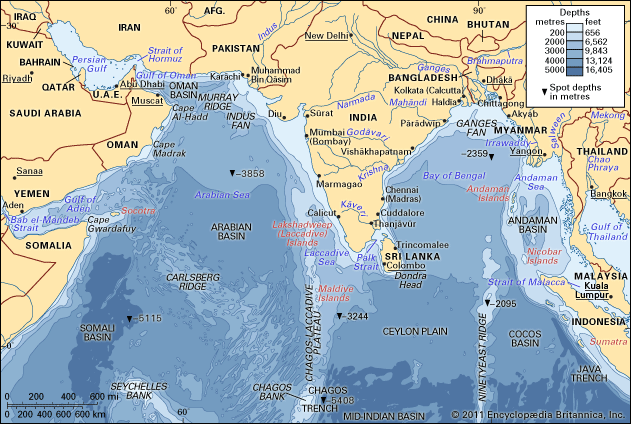
Lower Burma is a historical and geographic division of Burma (Myanmar) that encompasses the southern coastal and delta regions bordering the Bay of Bengal…
What is Lower Burma?
Lower Burma is a historical and geographic division of Burma (Myanmar) that encompasses the southern coastal and delta regions bordering the Bay of Bengal and the Andaman Sea.1
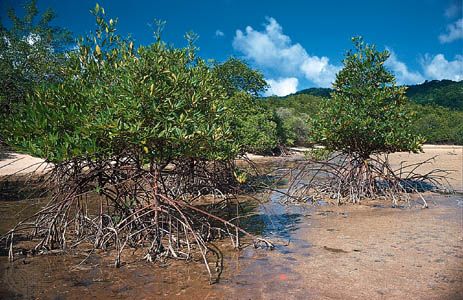
Historically, this region served as the center of the Mon kingdoms. It was acquired by the British Indian government in 1826 and 1852, a period that accentuated the distinction between the coastal south and the northern heartland of Upper Burma. Under British colonial rule, the region underwent a massive economic transformation; the Irrawaddy delta was cleared of mangrove forests and converted into a vast, export-oriented rice-growing hub1. While this development made Lower Burma the country’s principal agricultural region, the benefits were largely captured by foreign interests rather than the local population. Today, Yangon remains the largest city in the area.123
How did the British colonization of Burma change its traditional economy?
British colonization fundamentally dismantled the traditional Burmese economic system, which had previously prioritized agrarian self-sufficiency and state-regulated commodity distribution over supply and demand. Under British rule, the economy was forcibly integrated into a western colonial model designed to benefit foreign interests rather than the local population.4
The opening of the Suez Canal triggered a massive expansion of rice production in Lower Burma, where mangrove forests were cleared to create millions of acres of farmland. However, this growth was predatory: farmers were forced to borrow capital from Indian moneylenders at exorbitant rates, as British banks refused to provide agricultural loans. British firms monopolized wholesale trade, petroleum, timber, and transportation, while Indian laborers displaced local workers. This systemic exploitation led to widespread land dispossession, social disintegration, and a sharp rise in crime.4
Ultimately, while infrastructure and trade volume increased, the wealth generated was extracted by foreign entities, leaving the Burmese people impoverished and marginalized within their own country.4
What are the main geographic differences between Upper and Lower Burma?
The geographic distinction between Upper and Lower Burma is primarily defined by climate, topography, and proximity to the coast.
Upper Burma
- Geography: Comprises the central and northern portions of the country, serving as the nation’s heartland.2
- Climate: Characterized as a “dry zone,” it lies within the rain shadow of the Arakan Mountains.2
- Topography: The region is bisected by the Irrawaddy River, which flows through open alluvial flats in the central dry zone after passing through narrow defiles in the north.6
Lower Burma
- Geography: Consists of the southern coastal and delta regions bordering the Bay of Bengal and the Andaman Sea.1
- Topography: Dominated by the Irrawaddy Delta, a low-lying landscape formed by fine silt and fertile alluvium deposited by the river.6
- Environment: Unlike the dry interior, this region experiences heavy rainfall, which supports its role as the country’s primary agricultural hub.61
Who were the Mon people and what was their role in Lower Burma?
The Mon are an indigenous people of Southeast Asia who played a foundational role in the cultural and religious development of Myanmar. Migrating from western China, they established early kingdoms in the Chao Phraya River basin before moving into the Irrawaddy River delta of southern Myanmar by the 9th century.910
Cultural and Religious Influence
The Mon were instrumental in shaping the identity of the region. They adopted Theravada Buddhism and the Pali script through early contact with India, subsequently acting as cultural teachers to their neighbors. When the Burman kingdom of Pagan conquered the Mon capital of Thaton in 1057, the resulting influx of Mon monks and scholars led to the conversion of the Burmans to Theravada Buddhism and the adoption of the Mon alphabet.91110
Role in Lower Burma
Based in cities like Thaton and later Bago (Pegu), the Mon controlled the trade of southern Myanmar, serving as a vital link between the region and international maritime commerce. Despite centuries of conflict with the Burmans, the Mon maintained periods of independence until their final subjugation in 1757. Today, they remain centered in southeastern Myanmar, preserving a distinct heritage that remains a cornerstone of the region’s history.9111210
Sources
- Lower Burma — Encyclopædia Britannica
- Upper Burma — Encyclopædia Britannica
- Myanmar - The colonial economy — Encyclopædia Britannica
- history of Myanmar - The colonial economy — Encyclopædia Britannica
- Irrawaddy River - Irrigation — Encyclopædia Britannica
- Irrawaddy River - Physiography — Encyclopædia Britannica
- Salween River — Encyclopædia Britannica
- Shan Plateau — Encyclopædia Britannica
- Mon kingdom — Encyclopædia Britannica
- Mono — Encyclopædia Britannica
- history of Myanmar - The Mon — Encyclopædia Britannica
- Myanmar - The Mon — Encyclopædia Britannica
- Mon — Encyclopædia Britannica
Published on · 3 min read