Maipo Volcano
Maipo Volcano is a prominent volcanic peak situated in the central Andes Mountains of South America. Located directly on the border between Chile and…
What is Maipo Volcano?
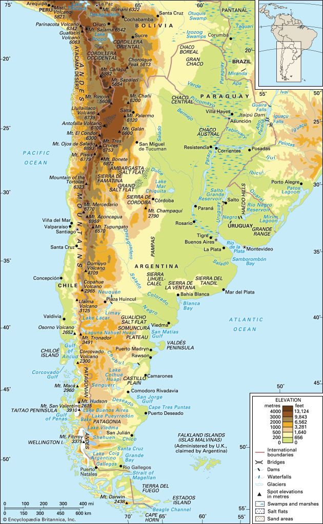
Maipo Volcano is a prominent volcanic peak situated in the central Andes Mountains of South America. Located directly on the border between Chile and Argentina, it stands at an elevation of 17,270 feet (5,264 meters) and is positioned approximately 65 miles (105 km) southeast of Santiago.1
Recognized as one of the most active volcanoes along the border, Maipo is notable for its geological history, including a significant eruption in 1826 that led to the creation of Diamante Lake near its summit.1
How do volcanoes form in the Andes Mountains?
Volcanoes in the Andes Mountains are primarily formed through the process of subduction, a key component of global plate-tectonic forces.2
The formation process involves the following dynamics:
- Plate Convergence: The Nazca Plate, which consists of dense oceanic crust, is moving eastward and colliding with the lighter continental crust of the South American Plate.23
- Subduction and Magma Generation: As the Nazca Plate is forced beneath the South American Plate, it descends into the mantle. This process triggers the intrusion of significant quantities of magma from the mantle into the overlying crust.23
- Volcanic Arc Formation: This magma rises to the surface, creating a nearly continuous chain of volcanoes along the western edge of the South American continent. This volcanic activity has been a defining feature of the region since the Cenozoic Era, contributing to the growth of the Andean cordilleras.423
These volcanoes are part of the larger circum-Pacific volcanic chain, often referred to as the Ring of Fire, and the region remains highly active today.2
What is the significance of the Chile-Argentina border in geography?
The border between Chile and Argentina is geographically and physically significant primarily because it is defined by the Andes Mountains.77
This mountain chain serves as a major natural boundary, acting as both a physical and a human divide between the two nations. The significance of this border region includes:7
- Geological Barrier: The Andes form a formidable, high-altitude barrier that stretches for thousands of miles. This system includes some of the highest peaks in the region, such as Mount Tupungato and Maipo Volcano, which are capped by eternal snow that feeds the river systems of central Chile.7
- Climatic and Ecological Influence: The mountains create distinct environmental conditions on either side. In the south, the border region is characterized by glacial landscapes, deep fjords, and extensive ice fields, such as the Southern Ice Cap, which is the largest in the Southern Hemisphere outside of Antarctica.78
- Resource and Conservation Value: The region is rich in geological history, containing significant mineral deposits, including copper, iron, and silver, which have historically shaped the economic landscape of the borderlands. Additionally, both nations have established national parks along this mountainous frontier to preserve the area’s natural beauty and diverse ecosystems.78
How do volcanic eruptions create crater lakes like Diamante Lake?
Volcanic eruptions create crater lakes through several distinct geological processes, primarily involving the formation of depressions that subsequently fill with water.12
- Caldera Collapse: Many large crater lakes form when a volcano’s magma chamber is rapidly emptied during a massive eruption. Without the support of the underlying magma, the top of the volcanic cone collapses into the void, creating a large, bowl-shaped depression known as a caldera.812
- Explosion Craters and Maars: Lakes can also occupy craters formed by explosive volcanic activity. Maars, for instance, are broad, low-relief volcanic craters created by explosions that occur when magma interacts with groundwater.12
- Volcanic Damming: In some cases, a lake is formed not within a crater, but by lava flows that interrupt and block existing drainage patterns, causing water to accumulate behind the volcanic barrier.12
Once these depressions are formed, they may be filled by precipitation or groundwater, resulting in the creation of a lake. Over time, secondary volcanic activity can sometimes build new cones or islands within these basins.812
Sources
- Maipo Volcano — Encyclopædia Britannica
- South America - The Central Andes — Encyclopædia Britannica
- mountain - The Andes — Encyclopædia Britannica
- Andes Mountains - Geology — Encyclopædia Britannica
- Nazca Plate — Encyclopædia Britannica
- Andes Mountains - Physiography of the Northern Andes — Encyclopædia Britannica
- Argentina - Land — Encyclopædia Britannica
- Chile - The Chilean Andes — Encyclopædia Britannica
- Andes Mountains - Physiography of the Southern Andes — Encyclopædia Britannica
- Chile — Encyclopædia Britannica
- Chile - The War of the Pacific (1879–83) — Encyclopædia Britannica
- caldera — Encyclopædia Britannica
- lake - Basins formed by wind action , animal activity, and meteorites — Encyclopædia Britannica
- lake - Basins formed by tectonism , volcanism, and landslides — Encyclopædia Britannica
Published on · 3 min read