Mexico Basin
The Mexico Basin is a triangular-shaped ocean area that covers a significant portion of the floor of the Gulf of Mexico. Located northwest of the Campeche…
What is Mexico Basin?
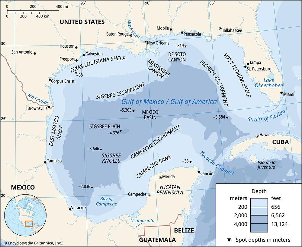
The Mexico Basin is a triangular-shaped ocean area that covers a significant portion of the floor of the Gulf of Mexico. Located northwest of the Campeche Bank, the basin generally lies between 22° and 26° N and 89° and 95° W.1
The area is characterized by deep waters, with depths typically exceeding 11,000 feet (3,400 meters). Its deepest point is the Sigsbee Deep, which reaches 17,070 feet (5,203 meters). The basin floor is largely flat, though it features the Sigsbee Knolls—a series of hills believed to be the result of underlying salt domes rising toward the surface.1
It is important not to confuse this geological feature with the “Valley of Mexico” (or Anáhuac), which is a high-altitude landlocked basin in central Mexico that served as a major center for pre-Columbian civilizations, including the Aztec empire.234
What were chinampas and how did they help Aztec agriculture?
Chinampas were small, stationary, artificial islands constructed for agricultural purposes in the shallow freshwater lakes of the Valley of Mexico. Often misnamed “floating gardens,” these fields were built by layering vegetation, dirt, and mud to create narrow, raised ridges—typically 6 to 10 meters wide and 100 to 200 meters long—that sat about one foot above the water level.101112
This system was a cornerstone of Aztec agriculture and was essential for supporting the dense population of the region. Chinampas helped agriculture in several key ways:1314
- Natural Irrigation and Fertilization: The surrounding lake water provided constant moisture, while the nutrient-rich mud and decomposing organic waste scooped from the lake floor acted as a natural fertilizer, maintaining high soil fertility.1012
- High Productivity: Due to the mild climate and constant water supply, the chinampas allowed for intensive cultivation and multiple harvests per year.14
- Land Reclamation: The technique enabled the Aztecs to convert unproductive swamps and waterlogged lakeshores into highly productive farmland, effectively expanding their agricultural base.1314
How did the geography of the Valley of Mexico influence the location of Tenochtitlán?
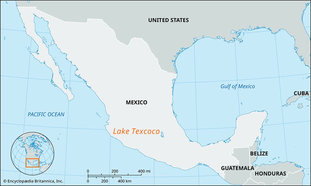
The geography of the Valley of Mexico played a decisive role in the founding and development of Tenochtitlán. In 1325, the Aztecs settled on a small, swampy island in Lake Texcoco after receiving a divine sign. This location was initially uninviting and unclaimed by the established powers of the region, providing the Aztecs with a refuge that they eventually transformed into a powerful capital through land reclamation and the construction of chinampas.15151612
The lake system—which included lakes Texcoco, Chalco, Xochimilco, Xaltoca, and Zumpango—was vital to the city’s success. It facilitated extensive water transportation, which compensated for the lack of pack animals and the wheel, fostering economic and political unification. The Aztecs leveraged their strategic position to build causeways connecting the island to the mainland, while also developing sophisticated aqueducts and flood-control levees to manage the lacustrine environment. This unique geography allowed the city to grow into a dense, highly productive urban center that served as the political and economic hub of the Aztec empire.151617
What are the main differences between the Mexican highlands and lowlands?
The geography of Mexico is defined by a complex interplay of elevation and topography, which creates significant distinctions between the highlands and the lowlands.
The Highlands
The highlands are dominated by the Mexican Plateau, which is flanked by the Sierra Madre Occidental and Sierra Madre Oriental mountain ranges. This region is further divided into two main sections:21
- Mesa del Norte: A vast, arid to semiarid northern plateau characterized by desert conditions, ephemeral drainage basins, and lower elevations (averaging about 4,000 feet).215
- Mesa Central: Located to the south, this region sits at higher elevations (6,000–9,000 feet) and is generally flatter, moister, and more fertile than the north. It serves as the country’s cultural and historical core, featuring numerous intermontane basins that have historically supported dense populations and intensive agriculture.212223
The Lowlands
The lowlands consist primarily of coastal plains and peninsulas, including the Pacific Coastal Lowlands, the Gulf Coastal Plain, and the Yucatán Peninsula.21
- Climate: Unlike the temperate highlands, the lowlands are characterized by the tierra caliente (“hot land”) zone, featuring uniformly high temperatures and, in many areas, abundant rainfall.245
- Terrain: These regions are often marked by lagoons, swampy areas, and tropical rainforests. While parts of the Pacific lowlands are arid, the Gulf Coastal Plain and southern regions benefit from rich alluvial soils that support commercial agriculture, including tropical crops like sugarcane, bananas, and coffee.21525
Key Differences
Feature
Highlands
Lowlands
Elevation
High (4,000–9,000+ feet)
Low (Sea level to 3,000 feet)
Climate
Vertical zones (
templada
,
fria
); generally cooler
Tierra caliente
; hot and humid
Agriculture
Corn, beans, wheat; subsistence and traditional
Tropical crops (sugarcane, coffee, fruit); commercial
Topography
Plateaus, basins, and rugged mountains
Coastal plains, swamps, and karst terrain
Sources
- Mexico Basin — Encyclopædia Britannica
- Lake Texcoco — Encyclopædia Britannica
- Pre-Columbian civilizations - Mesoamerican civilization — Encyclopædia Britannica
- Mesoamerican civilization — Encyclopædia Britannica
- Sierra Madre - Geology — Encyclopædia Britannica
- history of Latin America - The central areas in the mature period — Encyclopædia Britannica
- history of Latin America - Conquest of Mexico — Encyclopædia Britannica
- Mexico - Early , Middle, and Late Formative periods — Encyclopædia Britannica
- Middle American Indian - Cultural areas — Encyclopædia Britannica
- Chinampa — Encyclopædia Britannica
- Pre-Columbian civilizations - Agriculture — Encyclopædia Britannica
- Mexico City - Ancient foundations — Encyclopædia Britannica
- Mesoamerican Indian - Economic institutions — Encyclopædia Britannica
- Aztec - Aztec agriculture — Encyclopædia Britannica
- Tenochtitlán — Encyclopædia Britannica
- Mexico - The rise of the Aztecs — Encyclopædia Britannica
- Aztec - Origins of the Aztec people — Encyclopædia Britannica
- Pre-Columbian civilizations - Tenochtitlán — Encyclopædia Britannica
- Mexico City - City site — Encyclopædia Britannica
- Mexico City - The razing of Tenochtitlán and the emergence of Mexico City — Encyclopædia Britannica
- Mexico - Physiographic regions — Encyclopædia Britannica
- Mexico - Cultural regions — Encyclopædia Britannica
- Sierra Madre - Climate — Encyclopædia Britannica
- Mexico - Climate — Encyclopædia Britannica
- Mexico - Agriculture — Encyclopædia Britannica
- Mesa Central — Encyclopædia Britannica
Published on · 4 min read