Montgenèvre Pass
The Montgenèvre Pass is a mountain pass located at an elevation of 6,083 feet (1,854 meters) in the Cottian Alps of southeastern France, near the border with…
What is Montgenèvre Pass?
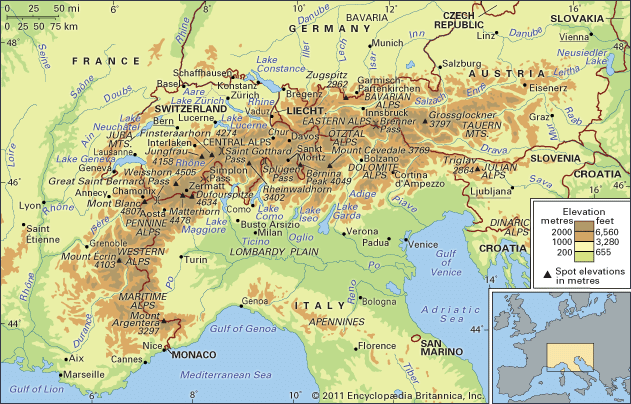
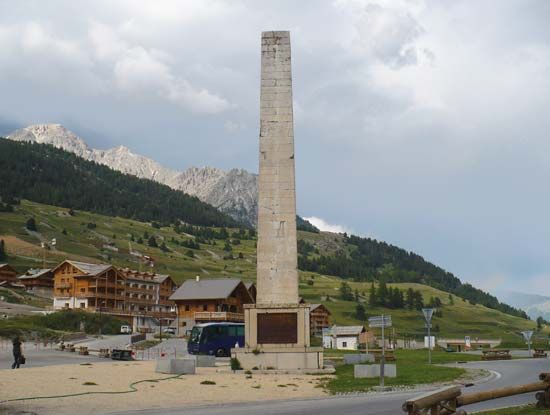
The Montgenèvre Pass is a mountain pass located at an elevation of 6,083 feet (1,854 meters) in the Cottian Alps of southeastern France, near the border with Italy. Situated near the town of Briançon, it serves as a vital link between the Durance River valley in France and the Dora Riparia valley in Italy.1
Historically, the pass was opened in 77 BCE by the Roman general Pompey the Great, subsequently becoming the primary route over the Alps into the Roman province of Gallia Comata. Its strategic importance continued into the modern era, with Napoleon commissioning a road across it between 1802 and 1807. Although it previously sat directly on the French-Italian border, the boundary was adjusted following the Treaty of Paris in 1947. Today, the nearby village of Montgenèvre is well-known as a destination for winter sports.12
How did the Romans use mountain passes for military travel?
The Romans viewed mountain passes as essential strategic components of their Roman road system, which was built primarily to facilitate military movement, administration, and the rapid deployment of soldiers across the empire.31
To maintain the efficiency of these routes through challenging terrain, Roman engineers employed several sophisticated techniques:
- Uniform Elevation: In mountainous regions, engineers prioritized maintaining a consistent gradient. They achieved this by cutting wide curves into the landscape and constructing arched bridges and viaducts to span deep valleys or rivers.3
- Tunneling: When faced with insurmountable obstacles, they utilized cuniculi—a technique involving vertical shafts for ventilation and spoil removal—and counter-excavation, where teams dug from opposite sides of a mountain to meet in the center.3
- Strategic Infrastructure: Passes like the Montgenèvre Pass, opened by Pompey the Great in 77 BCE, were vital for connecting the Roman heartland to provinces like Gallia Comata. These routes were often supported by mansiones (stopping places) and mutationes (relay stations), which provided essential supplies and fresh horses for official military and government travelers.34
By standardizing these construction methods, the Romans ensured that their military could traverse even the most rugged landscapes with relative speed and reliability.31
What are some other famous mountain passes in the Alps?
Beyond the Montgenèvre Pass, the Alps feature several other historically and strategically significant mountain passes:
- Great St. Bernard Pass: Located at 8,100 feet (2,469 meters) on the Italian-Swiss border, this was historically one of the most important trans-Alpine routes. It famously hosted a temple to Jupiter Poeninus and was used by Napoleon to lead 40,000 troops into Italy in 1800.
- Brenner Pass: At 4,511 feet (1,375 meters), this is one of the lowest and most vital passes. Since Roman times, it has served as a primary trade and military route connecting Germany to the Po River valley in Italy.
- Simplon Pass: Situated in southern Switzerland at 6,581 feet (2,006 meters), it gained major prominence after Napoleon constructed a carriage road through the Gorge of Gondo between 1800 and 1807.
- Stelvio Pass: Reaching an elevation of 9,042 feet (2,756 meters), this is one of the highest road passes in Europe, connecting the upper Adige and Adda river valleys.
- Albula Pass: Located in eastern Switzerland, this pass reaches 7,585 feet (2,312 meters) and has served as a key route to the Engadin valley since the 13th century.
How did Napoleon influence the development of Alpine roads?
Napoleon played a pivotal role in modernizing Alpine infrastructure to facilitate military movement and regional connectivity. His influence was characterized by the construction of major carriage roads that transformed previously difficult mountain passes into vital links between central and southern Europe.8
Key developments under his rule included:
- Simplon Pass: Between 1800 and 1807, Napoleon commissioned the construction of a carriage road through the Gorge of Gondo. This project significantly elevated the pass’s status, allowing it to compete with other major Alpine routes as a primary transit corridor.8
- Strategic Military Transit: Napoleon utilized existing, challenging routes for large-scale troop movements, such as his 1800 march with 40,000 soldiers across the Great St. Bernard Pass.6
- Broad Infrastructure Reform: Beyond specific passes, Napoleon’s administration prioritized the improvement of roads throughout his territories as part of a broader program of public works. These efforts were intended to hasten social and economic cohesion, modernize services, and support the logistical demands of his empire.14
Sources
- Montgenèvre Pass — Encyclopædia Britannica
- Little Saint Bernard Pass — Encyclopædia Britannica
- Roman road system — Encyclopædia Britannica
- road - The Roman roads — Encyclopædia Britannica
- Hannibal - The Alpine crossing of Hannibal — Encyclopædia Britannica
- Great St. Bernard Pass — Encyclopædia Britannica
- Brenner Pass — Encyclopædia Britannica
- Simplon Pass — Encyclopædia Britannica
- Alps - Transportation — Encyclopædia Britannica
- Albula Pass — Encyclopædia Britannica
- Stelvio Pass — Encyclopædia Britannica
- Alps — Encyclopædia Britannica
- Alpes — Encyclopædia Britannica
- Italy - Northern and central Italy — Encyclopædia Britannica
Published on · 3 min read