Mirim Lagoon
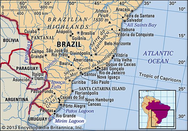
Mirim Lagoon is a shallow Atlantic tidewater lagoon situated on the border between Brazil (specifically the state of Rio Grande do Sul) and Uruguay.
What is Mirim Lagoon?
Mirim Lagoon is a shallow Atlantic tidewater lagoon situated on the border between Brazil (specifically the state of Rio Grande do Sul) and Uruguay.1
Spanning approximately 118 miles (190 km) in length and reaching 30 miles at its widest point, the lagoon covers an area of 1,542 square miles (3,994 square km). It is separated from the ocean by a low, marshy bar that ranges from 10 to 35 miles in width and contains smaller lagoons.1
The lagoon drains in a northeasterly direction into the Patos Lagoon via the São Gonçalo Canal. Due to its depth, it is navigable by shallow-draft vessels.12
How does the São Gonçalo Canal connect Mirim Lagoon to Patos Lagoon?
The São Gonçalo Canal serves as the vital hydrological link between the two bodies of water, allowing Mirim Lagoon to drain in a northeasterly direction into the Patos Lagoon.1
Specifically, the canal functions as the conduit for the overflow from Mirim Lagoon, which enters the southern portion of Patos Lagoon. Because the canal is navigable, it facilitates the movement of shallow-draft vessels between these two significant coastal features in Rio Grande do Sul, Brazil.12
What are the main differences between a lagoon and a lake?
The primary distinction between a lagoon and a lake lies in their geological environment and their relationship with the sea.
Lagoons
A lagoon is a body of relatively shallow, quiet water located in a coastal environment. Its defining characteristic is that it has access to the sea but is separated from open marine conditions by a barrier, such as a sandbar, a barrier island, or a coral reef. Because of this connection, lagoonal waters are often influenced by tidal influx and egress.45
Lakes
A lake is a relatively large body of standing or slowly moving water that occupies an inland basin. Unlike lagoons, lakes are typically inland features and are not defined by a barrier separating them from the ocean. While precise scientific distinctions between various bodies of water can be difficult to establish, lakes are generally characterized by their size and depth, often exhibiting stratification in temperature, light penetration, and oxygen concentration.67
In summary, while both are bodies of water, a lagoon is a coastal feature defined by its separation from the sea, whereas a lake is an inland feature defined by its position within a land basin.46
How do sandbars and marshy barriers form along coastlines?
Sandbars and barrier islands are dynamic coastal features shaped primarily by the interaction of waves, longshore currents, and sediment supply.121314
Formation of Sandbars
Sandbars are ridges of sand or coarse sediment built by wave action offshore from a beach. As waves break, the resulting turbulence excavates a trough in the sandy bottom. Some of this displaced sand is carried onto the beach, while the remainder is deposited on the offshore flank of the trough. Sand suspended in backwash and rip currents further contributes to the bar’s growth. These features are most pronounced during stormy seasons when heavy surf increases their relief, though they often remain submerged.15
Formation of Barrier Islands and Marshy Barriers
Barrier islands are elongate, sand-based features that parallel the shore. They typically form through the deposition of material by waves and longshore currents, often building up an equilibrium profile on a flat gradient.1614
- Emergence: Barrier bars may become exposed during periods of low sea level or following storm events, where they are further built up by swash and wind-carried sand.15
- Dune Development: Wind carries sediment landward from the beach, depositing it around obstructions to form coastal dunes, which help stabilize the barrier.17
- Marshy Environments: On the landward side of these barriers, protected environments such as tidal flats and marshes develop. If the land behind the barrier is low and sea levels rise slowly, the area may flood to create a lagoon, providing the calm, sediment-rich conditions necessary for marsh vegetation to take root.1614
Sources
- Mirim Lagoon — Encyclopædia Britannica
- Patos Lagoon — Encyclopædia Britannica
- lagoon - Dimensions — Encyclopædia Britannica
- lagoon — Merriam-Webster
- lagoon — Encyclopædia Britannica
- lake — Merriam-Webster
- lagoon - Barrier bars and sediment sources — Encyclopædia Britannica
- lake — Encyclopædia Britannica
- lagoon - Barrier island lagoons — Encyclopædia Britannica
- list of lakes - North America — Encyclopædia Britannica
- lacustrine ecosystem — Encyclopædia Britannica
- coastal landforms - Factors and forces in the formation of coastal features — Encyclopædia Britannica
- sandbar — Encyclopædia Britannica
- lagoon - Waves , tides, and surf — Encyclopædia Britannica
- coastal landforms - Tides — Encyclopædia Britannica
- coastal landforms - Longshore currents — Encyclopædia Britannica
- sandbars — Merriam-Webster
- coastal landforms - Barrier island/estuarine systems — Encyclopædia Britannica
- coastal landforms - Coastal dunes — Encyclopædia Britannica
Published on · 3 min read