Cape São Tomé
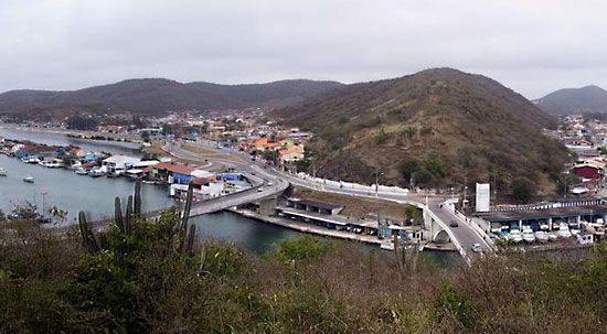
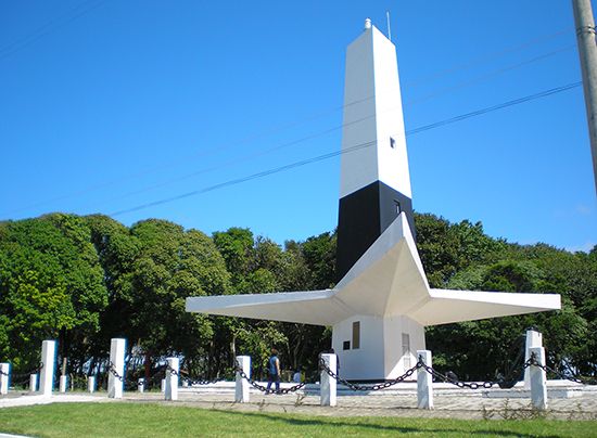
Cape São Tomé is a headland located on the Atlantic coast of eastern Brazil, in the state of Rio de Janeiro. Situated approximately 25 miles (40 km)…
What is Cape São Tomé?
Cape São Tomé is a headland located on the Atlantic coast of eastern Brazil, in the state of Rio de Janeiro. Situated approximately 25 miles (40 km) southeast of the city of Campos, the cape was formed by sediment deposits from the Paraíba do Sul River, which empties into the ocean about 25 miles to the north. Europeans first sighted this geographic feature in 1501.1
It is important to distinguish this Brazilian headland from the island nation of São Tomé and Príncipe, which is located off the western coast of Africa in the Gulf of Guinea. While the two share a name, they are distinct locations with different histories and geographic contexts.12
How do rivers create headlands like Cape São Tomé?
Headlands like Cape São Tomé are primarily formed through the process of sedimentation. When a river carries a significant load of material—such as sand, silt, and clay—to the coast, it creates a depositional environment. If the amount of sediment deposited at the river mouth exceeds what can be removed by coastal processes like waves, tides, and currents, the material accumulates and extends beyond the natural trend of the coastline.13
The specific shape and size of these features are determined by the interaction between the river’s discharge and the energy of the ocean. In areas where wave and tidal energy are relatively low, the river can build outward, creating distinct landforms. Over time, these accumulated sediment bodies can form headlands or deltas that alter the local geography. While erosional forces like storms or rising sea levels can reshape these areas, the long-term tendency in such depositional zones is for the land to build up as more material is supplied by the river system.3456
What is the difference between the Brazilian cape and the island nation of São Tomé and Príncipe?
Cape São Tomé and the nation of São Tomé and Príncipe are distinct geographic entities separated by the Atlantic Ocean.
- Cape São Tomé: This is a headland located on the Atlantic coast of eastern Brazil, specifically in the state of Rio de Janeiro. It was formed by sediment deposits from the Paraíba do Sul River and was first sighted by Europeans in 1501.1
- São Tomé and Príncipe: This is an island country located in the Gulf of Guinea off the western coast of Central Africa. It consists of two main islands, São Tomé and Príncipe, along with several smaller islets. The nation has a distinct history as a former Portuguese colony, gaining independence in 1975.91011
While they share a name, they occupy entirely different continents and serve different geographic functions.
What are some other major geographical features along the coast of Brazil?
Brazil’s coastline is remarkably diverse, featuring a variety of landforms shaped by the interaction between the Atlantic Ocean and the country’s rugged interior topography.
Coastal Lowlands and Beaches
The Atlantic lowlands vary significantly in width, ranging from expansive floodplains and swamps to narrow strips of land where coastal ranges meet the sea. Long stretches of white sandy beaches are common, often protected by coral reefs or barrier islands. In the Northeast, these beaches are frequently bordered by taboleiros—mesa-like sedimentary formations that rise sharply above the shoreline.141516
Bays and Harbors
Where the rocky slopes of coastal ranges plunge directly into the ocean, deep natural harbors have formed. Notable examples include:
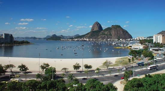
- Guanabara Bay: A major bay flanked by iconic landmarks such as Sugar Loaf Mountain.1417
- All Saints Bay: The site of the city of Salvador.14
Lagoons and Promontories
In the South, the coastal plain widens to accommodate massive lagoons, such as Patos Lagoon and Mirim Lagoon. Additionally, the coast is punctuated by prominent capes, such as Cape Frio and Cape Branco, the latter of which serves as the easternmost point of the South American continent.141518
Sources
- Cape São Tomé — Encyclopædia Britannica
- Sao Tome and Principe - Portuguese colonial rule — Encyclopædia Britannica
- coastal landforms - Landforms of depositional coasts — Encyclopædia Britannica
- coastal landforms - Deltas — Encyclopædia Britannica
- coastal landforms - Landforms of erosional coasts — Encyclopædia Britannica
- coastal landforms - Factors and forces in the formation of coastal features — Encyclopædia Britannica
- river - Sedimentation in estuaries — Encyclopædia Britannica
- coast — Encyclopædia Britannica
- Sao Tome and Principe — Encyclopædia Britannica
- Sao Tome and Principe - History of Sao Tome and Principe — Encyclopædia Britannica
- Sao Tome and Principe - Land — Encyclopædia Britannica
- São Tomé — Encyclopædia Britannica
- São Tomé — Merriam-Webster
- Brazil - Coastal lowlands — Encyclopædia Britannica
- Paraíba do Sul River — Encyclopædia Britannica
- Brazil - Brazilian Highlands — Encyclopædia Britannica
- Cape Branco — Encyclopædia Britannica
- Cape Frio — Encyclopædia Britannica
- Guanabara Bay — Encyclopædia Britannica
- Brazil - Geographic regions — Encyclopædia Britannica
- Paraíba — Encyclopædia Britannica
Published on · 3 min read