Mýrdalsjökull
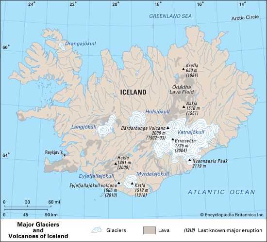
Mýrdalsjökull is a glacier located in southern Iceland. It spans approximately 30 miles (48 km) in length and 20 miles (32 km) in width, covering an area of…
What is Mýrdalsjökull?
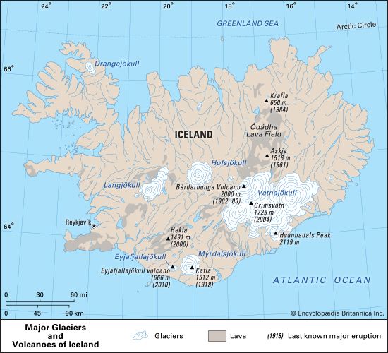
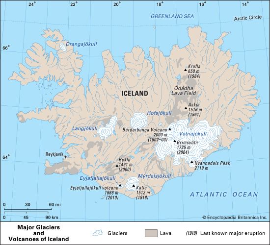
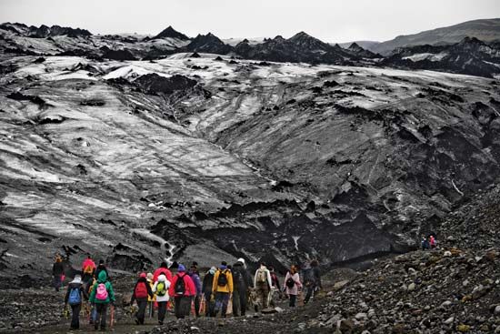
Mýrdalsjökull is a glacier located in southern Iceland. It spans approximately 30 miles (48 km) in length and 20 miles (32 km) in width, covering an area of 268 square miles (695 square km).1
The glacier is historically linked to the nearby Eyjafjallajökull, from which it is now separated by the Fimmvörduhálss Pass. A defining feature of Mýrdalsjökull is that its southeastern section sits atop Katla, one of Iceland’s most active volcanoes.123
Because Katla is a subglacial volcano, its eruptions often melt significant amounts of overlying ice, leading to dangerous glacier outburst floods and lahars2. For instance, the 1918 eruption of Katla caused massive flooding that significantly altered the southern coastline of Iceland.13
What are glacier outburst floods?
Glacier outburst floods, known by the Icelandic term jökulhlaups, are sudden and often catastrophic releases of water stored within or behind a glacier.42
These events typically occur when internal drainage paths are blocked by the glacier’s plastic flow, causing water to accumulate. Once the water finds a narrow path to escape, the heat from the flowing water melts the surrounding ice, rapidly enlarging the conduit. This creates a feedback loop of increased flow and melting until the stored water is released in a sudden, massive surge.4
Outburst floods can be triggered by several factors:
- Volcanic Activity: Subglacial volcanoes, such as Katla or those under Vatnajökull, melt overlying ice, creating lakes that eventually breach their ice walls.56
- Ice Dams: The failure of ice dams, which can impound vast quantities of water in proglacial or subglacial lakes, has historically caused massive, landscape-altering floods.2
While some glaciers experience these floods on a predictable, regular basis, others release water at irregular intervals, making them difficult to forecast.4
How do volcanoes interact with glaciers to create lahars?
When a volcano erupts beneath or near a glacier, the intense heat from magma or volcanic activity rapidly melts the overlying ice and snow. This process generates massive quantities of meltwater that mix with loose volcanic debris, such as ash, soil, and rock fragments, to form a lahar—a destructive volcanic mudflow.728
These mudflows are highly dangerous because they move downslope at very high speeds and can travel for tens of miles, carrying material ranging from fine ash to large boulders. In the case of subglacial volcanoes like Katla in Iceland, the sudden release of this meltwater can cause catastrophic flooding that reshapes the surrounding landscape, as seen during the 1918 eruption when lahars significantly expanded the southern coastline. Even in the absence of a full-scale eruption, hydrothermal activity or smaller melting events can trigger these hazardous flows by destabilizing the glacier’s ice and surrounding sediment.728
What is the difference between a caldera and a typical volcano?
A common misconception is that a caldera is simply a type of volcano, when in fact it is a specific volcanic landform characterized by a large, bowl-shaped depression, typically exceeding 1 km (0.6 mile) in diameter.1011
The primary differences between a caldera and a typical volcano, such as a stratovolcano or shield volcano, include:
- Formation: While typical volcanoes are built up by the accumulation of lava, ash, and other materials over time, a caldera forms through the inward collapse of a landform. This collapse occurs when a large volume of magma is rapidly expelled from an underground reservoir, leaving the ground above without support.101211
- Size and Shape: Calderas are significantly larger than the craters found at the summits of typical volcanoes. A crater is a smaller vent-related feature, and it is possible for a crater to exist within a caldera, but not the reverse.1012
- Structure: Typical volcanoes often feature a prominent, cone-shaped peak. In contrast, a caldera is defined by its immense, sunken depression, which may later fill with water to form a lake, such as Crater Lake in Oregon.1312101411
Sources
- Mýrdalsjökull — Encyclopædia Britannica
- Katla — Encyclopædia Britannica
- Eyjafjallajökull — Encyclopædia Britannica
- glacier - Glacier floods — Encyclopædia Britannica
- ice jam — Encyclopædia Britannica
- Vatnajökull — Encyclopædia Britannica
- lahar — Encyclopædia Britannica
- volcano - Avalanches, tsunamis, and mudflows — Encyclopædia Britannica
- Iceland - Land — Encyclopædia Britannica
- volcano - Calderas — Encyclopædia Britannica
- Did you know? — Merriam-Webster
- volcano - Major types — Encyclopædia Britannica
- stratovolcano — Encyclopædia Britannica
- caldera — Encyclopædia Britannica
Published on · 3 min read