Qurnat al-Sawdāʾ
Qurnat al-Sawdāʾ is the highest peak in Lebanon, reaching an elevation of 10,131 feet (3,088 meters). Located within the Lebanon Mountains in the northern…
What is Qurnat al-Sawdāʾ?
Qurnat al-Sawdāʾ is the highest peak in Lebanon, reaching an elevation of 10,131 feet (3,088 meters). Located within the Lebanon Mountains in the northern part of the country, it sits approximately 45 miles (72 km) northeast of Beirut.12
The peak is a prominent feature of the landscape, characterized by its snowcapped summit. It is situated in a region of significant natural beauty, where the renowned Cedars of Lebanon grow in the shadow of the mountain. The surrounding range is composed primarily of limestone and sandstone, featuring deep, narrow gorges that define the complex topography of the area.23
What are the famous Cedars of Lebanon?
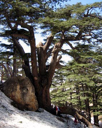
The cedar of Lebanon (Cedrus libani) is a long-lived, evergreen conifer native to the mountainous regions of the eastern Mediterranean. These trees are characterized by their massive trunks, spreading branches, and needlelike leaves that grow in dense tufts.45
Historically, these forests were abundant and highly valued for their durable, aromatic timber, which was widely exported for construction and shipbuilding in ancient times. Beyond their economic utility, the trees hold deep cultural and symbolic significance; they are mentioned in the Bible as emblems of strength and wealth and have long been associated with the Lebanese people. This connection is immortalized on the national flag of Lebanon, which features a green cedar tree at its center.67
Today, only remnants of these once-vast forests remain, primarily located on the western flanks of the Lebanon Mountains near Bsharrī. Due to centuries of grazing, burning, and logging, the natural vegetation has been significantly reduced, leading to modern efforts by environmental groups to protect the remaining groves.37
How do the Lebanon Mountains influence the country’s climate?
The Lebanon Mountains play a critical role in shaping the country’s climate by creating sharp local contrasts in weather conditions. As a major topographic feature, the range acts as a barrier that influences precipitation patterns and temperature distribution across the region.93
- Precipitation: While the coastal areas receive significant winter rainfall, the mountains force air masses to rise, causing precipitation to increase with altitude. Higher elevations receive more than 50 inches (1,270 mm) of precipitation annually, which often falls as heavy snow on the peaks and remains until early summer.9
- Temperature: Elevation significantly moderates temperatures. At higher settlements, such as those at 5,000 feet (1,524 meters), temperatures are approximately 15 °F (8 °C) cooler than those found on the coast.9
- Regional Variation: The mountains effectively separate the humid coastal strip from the interior. The Bekaa valley, located in the rain shadow of the mountains, is notably drier than the coast, receiving significantly less annual rainfall.93
What is the significance of the Bekaa Valley in Lebanon?
The Bekaa valley is a vital region of east-central Lebanon, stretching 75 miles (120 km) between the Lebanon Mountains and the Anti-Lebanon Mountains. Its significance is multifaceted, spanning agriculture, history, and geopolitics:
- Agriculture: The valley contains nearly half of Lebanon’s arable land. While drier than the coast, it is a key producer of sugar beets, cereals, vegetables, grains, and fruits. It is also known for the cultivation of cannabis, which was legalized in 2020 to support the economy, and for the production of arak in towns like Zahle.119
- Historical Heritage: The valley is home to Baalbek, a UNESCO World Heritage site featuring outstanding Roman ruins that reflect the region’s deep cultural history.1112
- Geopolitics and Conflict: Due to its strategic location, the valley has frequently been a site of conflict, including skirmishes during the Lebanese Civil War and, more recently, impacts from the Syrian Civil War and the Israel-Hezbollah war.11
Sources
- Qurnat al-Sawdāʾ — Encyclopædia Britannica
- Lebanon - Relief — Encyclopædia Britannica
- Lebanon Mountains — Encyclopædia Britannica
- cedar of Lebanon — Merriam-Webster
- Cedar — Encyclopædia Britannica
- flag of Lebanon — Encyclopædia Britannica
- Lebanon cedar — Merriam-Webster
- Lebanon - Plant and animal life — Encyclopædia Britannica
- Lebanon - Climate of Lebanon — Encyclopædia Britannica
- Levant — Encyclopædia Britannica
- Bekaa valley — Encyclopædia Britannica
- Lebanon - Cultural milieu — Encyclopædia Britannica
- Lebanon - Agriculture, forestry, and fishing — Encyclopædia Britannica
Published on · 3 min read