Sarek National Park
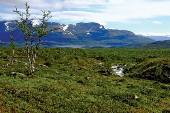
Sarek National Park is a protected wilderness area located in Norrbotten County in northwestern Sweden. Established in 1909, the park spans 746 square miles…
What is Sarek National Park?
Sarek National Park is a protected wilderness area located in Norrbotten County in northwestern Sweden. Established in 1909, the park spans 746 square miles (1,931 square km) and is known for its rugged, largely inaccessible terrain, which includes deep valleys, wide plateaus, glaciers, and high mountain peaks.1
The park is home to Mount Sarek, which stands at 6,854 feet (2,089 meters) and is the second-highest peak in Sweden. The landscape is drained by the Rapa River, which flows into Lake Laitaure. Sarek is ecologically significant for its rich vegetation and diverse wildlife, serving as a habitat for bears, wolves, wolverines, and lynxes. It is situated adjacent to two other national parks: Stora Sjöfallet to the north and Padjelanta to the west.1
Please note that Sarek National Park is distinct from Sariska National Park, which is a tiger reserve located in Rajasthan, India.2
What are the challenges of visiting an inaccessible wilderness like Sarek?
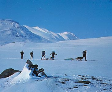
Visiting an inaccessible wilderness like Sarek National Park presents significant challenges for travelers. Because the region is characterized by rugged terrain—including high mountain peaks exceeding 6,500 feet, deep valleys, and extensive glaciers—it lacks the infrastructure found in more accessible parks.1
The absence of marked trails and bridges requires visitors to possess advanced navigation skills and the physical endurance to traverse challenging landscapes. Furthermore, the park’s remote nature means that help is not readily available, making self-sufficiency and thorough preparation essential for safety. The presence of diverse wildlife, such as bears and wolves, also necessitates a high level of awareness and respect for the natural environment.1
How do glaciers shape the landscape of the Scandinavian mountains?
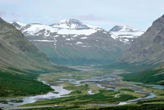
Glaciers have acted as powerful geological engines, fundamentally transforming the landscape of the Scandinavian mountains through extensive erosion and deposition during the Pleistocene Epoch.34
Erosional Impacts
The most dramatic changes occurred as glaciers moved through the region, reshaping the terrain:
- U-Shaped Valleys and Fjords: Glaciers scoured existing V-shaped river valleys, widening and deepening them into characteristic U-shaped valleys4. Along the western coast, these troughs were carved so deeply that they were later drowned by the ocean, creating the iconic fjords of Norway.56
- Mountain Sculpting: In higher elevations, glaciers carved out cirques—amphitheatre-shaped basins—at the heads of valleys. The intersection of these cirques created sharp, jagged features such as arêtes (knife-edge ridges) and horns (sharp peaks).78
- Bedrock Scouring: The movement of ice stripped away soil and weathered debris, polishing and streamlining the underlying bedrock into features like roches moutonnées.65
Depositional Impacts
As the ice sheets retreated, they left behind vast quantities of transported material:
- Sediment Deposits: Regions such as southern Sweden were covered in thick layers of glacial till, gravel, and sand, which helped create the relatively flat, fertile plains found in parts of the region today.34
- Drainage Changes: The melting ice altered regional drainage patterns, leaving behind numerous lakes and depressions scoured into the bedrock.64
What other national parks are located in Sweden?
In addition to Sarek National Park, Sweden features several other notable national parks, particularly in the northern region of Norrbotten. These include:
- Padjelanta National Park: Established in 1962, this is the largest national park in Sweden, covering 776 square miles. It is known for its diverse alpine flora and significant lakes, such as Virihaure and Vastenjaure.9
- Stora Sjöfallet National Park: Located to the north of Sarek, this park is part of the same protected mountain landscape.1
Sources
- Sarek National Park — Encyclopædia Britannica
- Sariska National Park — Encyclopædia Britannica
- glacial landform - Erosional landforms of continental glaciers — Encyclopædia Britannica
- glacial landform - Cirques , tarns, U-shaped valleys, arêtes, and horns — Encyclopædia Britannica
- Pleistocene Epoch - Glaciation — Encyclopædia Britannica
- Norway - Relief — Encyclopædia Britannica
- cirque — Encyclopædia Britannica
- Europe - Pleistocene glaciation — Encyclopædia Britannica
- Padjelanta National Park — Encyclopædia Britannica
- list of cities and towns in Sweden — Encyclopædia Britannica
Published on · 3 min read