Armenian Highland
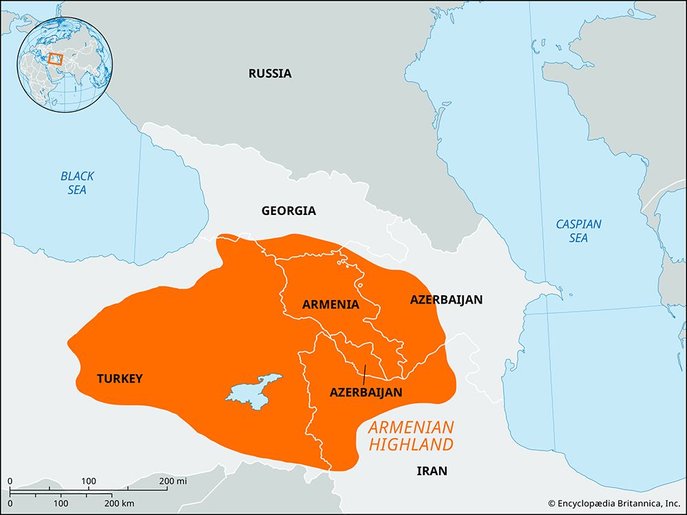
The Armenian Highland is a vast, mountainous region in western Asia covering nearly 154,400 square miles (400,000 square km). While it occupies the entirety…
What is Armenian Highland?
The Armenian Highland is a vast, mountainous region in western Asia covering nearly 154,400 square miles (400,000 square km). While it occupies the entirety of Armenia, the highland also extends into Turkey, southern Georgia, western Azerbaijan, and northwestern Iran.1
Geologically, the region is a segment of the Mediterranean alpine volcanic zone, characterized by lofty mountain ranges, deep river valleys, and lava plateaus dotted with extinct volcanoes. Its average elevation ranges between 5,000 and 6,500 feet (1,500 to 2,000 meters), with several peaks rising above 14,000 feet (4,000 meters). The area experiences a subtropical continental climate, which varies significantly based on elevation, and is rich in mineral resources such as chromite, gold, and iron.123
What is the significance of Lake Sevan in the region?
Lake Sevan is a vital geographical and economic feature of Armenia, situated at an elevation of 6,250 feet (1,905 meters) within a mountain-enclosed basin. Its significance to the region is multifaceted:6
- Hydrological Role: As the largest lake in the country, it serves as a major water reservoir with a capacity exceeding 9 cubic miles (39 cubic kilometers). It is fed by dozens of rivers and drains via the Hrazdan River, which is essential for irrigation and hydroelectric power generation.67
- Economic Importance: The lake supports a significant fishing industry, particularly known for its trout. Historically, the development of hydroelectric plants on the Hrazdan River impacted the lake’s water levels, necessitating the construction of a tunnel to divert water from the Arpa River for stabilization.6
- Cultural Heritage: The shores of Lake Sevan are home to several ancient Armenian churches, marking the area as a site of historical and cultural importance.6
How do the Lesser Caucasus mountains affect the local climate?
The northern slopes of the Lesser Caucasus mountains, which face the southern slopes of the Greater Caucasus, experience a climate similar to that of the latter at comparable elevations, with precipitation levels notably higher in the western sections of the range.910
More broadly, the influence of the Lesser Caucasus and the associated Armenian Highland is characterized by a moderately cold and continental climate on the upland plateaus. This environment fosters the development of semiarid steppe grasslands. In contrast, the higher elevations of these mountains feature a more humid, alpine climate marked by cool summers and cold, prolonged winters, with snow cover often persisting for four to five months of the year.910
What are some of the major rivers that flow through the Armenian Highland?
The Armenian Highland is characterized by a complex network of rivers that are generally short, turbulent, and possess significant hydroelectric potential due to the region’s high elevation.7
The major river systems flowing through or bordering the region include:
- Aras River: This is the primary drainage system for most of Armenia. It serves as a natural boundary between Armenia and its neighbors, Turkey and Iran, for approximately 300 miles. Its major left-bank tributaries, which are essential for irrigation, include:711
- Kura River: While it rises in Turkey and flows through Georgia and Azerbaijan, its tributaries—such as the Debed and Aghstev—pass through Armenia’s northeastern regions.712
- Tigris and Euphrates: These rivers have their headwaters in the eastern part of the Armenian Highland in Turkey, descending from elevations between 6,000 and 10,000 feet before flowing southeast through the Middle East.13
Sources
- Armenian Highland — Encyclopædia Britannica
- Armenia - Relief — Encyclopædia Britannica
- Armenia - Climate — Encyclopædia Britannica
- Armenia - Ottomans and Ṣafavids — Encyclopædia Britannica
- Armenia - The Arsacids — Encyclopædia Britannica
- Lake Sevan — Encyclopædia Britannica
- Armenia - Drainage — Encyclopædia Britannica
- Sevan — Merriam-Webster
- Caucasus - Climate — Encyclopædia Britannica
- Transcaucasia - Climate — Encyclopædia Britannica
- Caspian Sea - Shoreline features — Encyclopædia Britannica
- Kura River — Encyclopædia Britannica
- Tigris-Euphrates river system — Encyclopædia Britannica
- Aras River — Encyclopædia Britannica
- Tigris-Euphrates river system: Top Questions — Encyclopædia Britannica
Published on · 3 min read