Boundary Peak
Boundary Peak is the highest point in the U.S. state of Nevada, reaching an elevation of 13,147 feet (4,007 meters). Located in Esmeralda County, it serves…
What is Boundary Peak?
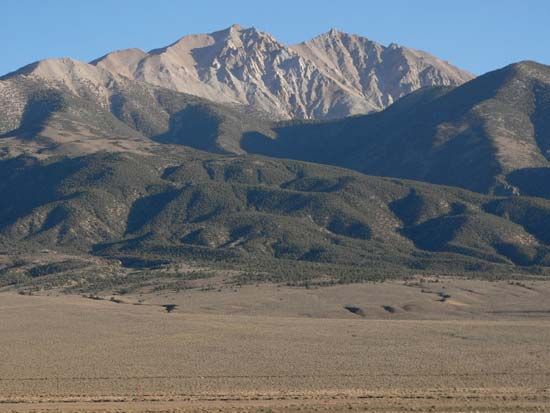
Boundary Peak is the highest point in the U.S. state of Nevada, reaching an elevation of 13,147 feet (4,007 meters). Located in Esmeralda County, it serves as the northernmost peak of the White Mountains and is situated within the Inyo National Forest.1
The peak is managed by the U.S. Forest Service and earned its name due to its proximity—less than 1/2 mile—to the California-Nevada border. Hikers can reach the summit via a moderately difficult 8-mile trail, though the peak remains snowcapped for the majority of the year. While some sources cite slightly varying elevations, it is officially recognized as the state’s highest summit.12
What are the White Mountains known for?
The term “White Mountains” refers to two distinct geographical regions in the United States, each known for unique features:
The White Mountains of New Hampshire and Maine
Located in the Appalachian Mountains, this range is renowned for containing the highest elevations in the northeastern United States. Key characteristics include:3
- The Presidential Range: A series of summits named after U.S. presidents, including Mount Washington, the highest peak in the region at 6,288 feet.3
- Glacial Notches: The landscape is defined by scenic, rounded mountain passes carved by glaciers, such as Franconia, Crawford, and Pinkham notches.3
- Recreation: Much of the area is protected within the White Mountain National Forest, offering over 1,000 miles of nature trails, extensive camping, and popular winter sports facilities.3
The White Mountains of California and Nevada
This range is primarily recognized for its ecological significance, specifically as the home of the Great Basin bristlecone pine. These trees are among the oldest living organisms on Earth, with some individuals in the range estimated to be over 5,000 years old.4
How do mountain elevations affect local climates?
Mountain elevations significantly influence local climates by creating diverse microclimates and mesoclimates. As altitude increases, temperature, atmospheric pressure, and humidity generally decrease. Because there is less air overhead, high-altitude regions experience increased solar radiation, particularly ultraviolet light.8
Mountains also act as physical barriers that dictate precipitation patterns. When moist air is forced to rise over a range, it cools and releases moisture as orographic precipitation, primarily on the windward side. Conversely, the leeward side often experiences a rain shadow, resulting in significantly drier conditions.89
Furthermore, mountains alter wind behavior through “funneling” effects in valleys and the creation of mountain-valley wind circulations. Cold air drainage can lead to “frost pockets” in low-lying areas, and high peaks may collect permanent snow and ice once they surpass the snow line. These factors collectively ensure that mountainous regions often function as cooler, wetter versions of the surrounding lowlands.8
What are some other famous high points in the United States?
The United States features a diverse array of famous high points, ranging from massive Alaskan peaks to iconic summits in the lower 48 states.
Notable High Points in the United States
- Denali: Located in the Alaska Range, this is the highest point in North America, reaching an elevation of 20,310 feet (6,190 meters).1112
- Mount Whitney: At 14,494 feet (4,418 meters), it is the highest mountain in the conterminous United States, situated in the Sierra Nevada range.13
- Mount Rainier: A prominent volcanic peak in the Cascade Range of Washington, rising to 14,410 feet (4,392 meters).13
- Mount Mitchell: The highest summit in the Appalachian Mountains, reaching 6,684 feet (2,037 meters) in North Carolina.14
- Mount Saint Elias: Standing at 18,008 feet (5,489 meters) on the border between Alaska and Canada, it is the fourth-highest point on the continent.11
- Mount Foraker: Located in the Alaska Range near Denali, it reaches 17,400 feet (5,304 meters).12
These peaks are significant not only for their elevation but also for their roles in mountaineering history and their influence on regional geography and climate.121315
Sources
- Boundary Peak — Encyclopædia Britannica
- Boundary Peak — Merriam-Webster
- White Mountains — Encyclopædia Britannica
- White Mountains — Merriam-Webster
- bristlecone pine — Encyclopædia Britannica
- California - Sports and recreation — Encyclopædia Britannica
- Sierra Nevada - Drainage and glaciation — Encyclopædia Britannica
- Highland climate — Encyclopædia Britannica
- Orographic precipitation — Encyclopædia Britannica
- Rocky Mountains - Climate — Encyclopædia Britannica
- North America: Top Questions — Encyclopædia Britannica
- Alaska Range — Encyclopædia Britannica
- Appalachian Mountains - Physiography — Encyclopædia Britannica
- Canadian Rockies — Encyclopædia Britannica
- United States - The Western Cordillera — Encyclopædia Britannica
- mountaineering - History — Encyclopædia Britannica
- list of mountains - North America — Encyclopædia Britannica
Published on · 3 min read