Drâa River
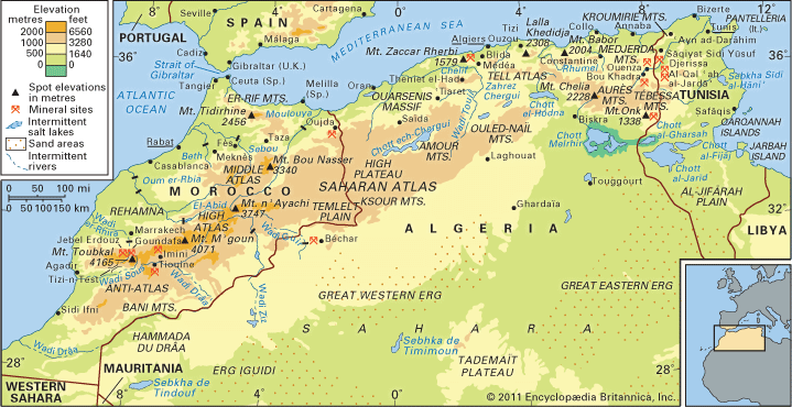
The Drâa River is an intermittent stream, or wadi, located in southern Morocco. It is the longest river in the country, stretching approximately 700 miles…
What is Drâa River?
The Drâa River is an intermittent stream, or wadi, located in southern Morocco. It is the longest river in the country, stretching approximately 700 miles (1,100 km) from its source in the High Atlas mountains to the Atlantic Ocean near Cap Drâa Atlas](https://www.britannica.com/place/High-Atlas) mountains to the Atlantic Ocean near Cap Drâa.1
The river originates at the confluence of two headstreams, the Dadès and the Imini. While it flows southeastward before turning southwest to form part of the border between Morocco and Algeria, the majority of the riverbed remains dry, with water primarily present only in the headstreams and the upper course. The river supports important oases, including Ouarzazate and Zagora1.21
What are the High Atlas mountains like?
The High Atlas is a prominent mountain range in central Morocco that extends 460 miles (740 km) from the Atlantic coast to the Algerian border. It features some of the highest peaks in the Atlas Mountains, including Mount Toubkal, which reaches an elevation of 13,665 feet (4,165 meters).45
The range is characterized by significant environmental contrasts:
- Vegetation: Northern slopes and lower peaks are forested with cork, oak, pine, cedar, and walnut trees. In contrast, the southern flanks are exposed to hot, dry Saharan winds and are largely barren.4
- Climate: The mountains experience harsh winters, and snow often remains on the peaks until the height of summer.6
- Human Geography: The region is home to the Berber (Amazigh) people, who live in fortified villages often perched on mountain crests. They practice terraced agriculture in deep river valleys, utilizing irrigation to grow crops like cereals and vegetables.7
- Economy: The area is rich in minerals, including copper, iron ore, lead, zinc, and manganese. Additionally, the region has become a popular destination for hiking and winter sports.48
How do people live in riverine oases?
Life in riverine oases is defined by a fragile ecological balance, where sedentary communities rely on intensive irrigation to cultivate crops in otherwise arid environments. Because water is the limiting factor for survival, these settlements are often located where perennial water sources—such as springs, wells, or diverted streams—are available.910
Agricultural Practices
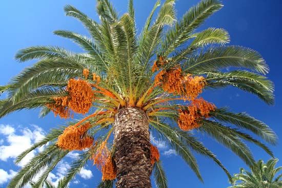
Oasis dwellers typically maintain small, labor-intensive “gardens”. The date palm serves as the primary food source and economic staple, providing shade that allows for the cultivation of a diverse understory of crops, including:10
- Cereals: Wheat, barley, and millet.910
- Fruits and Vegetables: Figs, peaches, apricots, citrus, and various vegetables.910
- Specialty Crops: Alfalfa and henna.10
Water Management
To sustain these crops, communities employ sophisticated irrigation techniques. In many regions, water is diverted from streams or transported from distant mountains via underground tunnels known as qanāts (or foggaras)ts](https://www.britannica.com/technology/qanat) (or foggaras). While ancient methods like the shadoof or animal-driven noria were once common, many modern oases now utilize motorized pumps.10
Settlement and Society
Settlements are often highly distinctive, featuring fortified adobe structures known as ksour (castles) to provide security. In some areas, such as the High Atlas valleys, communities construct terraced fields along valley walls to maximize arable land, often supplementing their agriculture with livestock like sheep and goats.111
What is the difference between a river and a wadi?
The primary difference between a river and a wadi lies in the consistency of their water flow, which is largely determined by the climate of the region in which they are located.121
Rivers
Rivers are typically defined as perennial streams, meaning they maintain a relatively constant flow of water throughout the year. They are most common in humid or temperate regions where consistent precipitation or snowmelt sustains their discharge. Even in arid environments, some large “allogenic” rivers can exist if they originate in humid highlands and carry water through dry landscapes, such as the Nile River.15121
Wadis
A wadi is an ephemeral watercourse—a channel that is usually dry and only carries water following heavy, irregular rainfall. These features are characteristic of arid desert environments. While they may appear dormant for long periods, wadis can experience sudden, destructive floods when intense rain occurs. In many cases, the water in a wadi is eventually lost to evaporation or percolation into the ground before it can reach a larger body of water.13121
It is important to note that these terms exist on a spectrum; some streams are intermittent, flowing only during certain seasons or when the groundwater table is sufficiently high.12
Sources
- Drâa River — Encyclopædia Britannica
- Morocco - Drainage — Encyclopædia Britannica
- Dadès River — Encyclopædia Britannica
- High Atlas — Encyclopædia Britannica
- Atlas Mountains - Climate of the Atlas Mountains — Encyclopædia Britannica
- Exploring 7 of Earth’s Great Mountain Ranges - Atlas Mountains — Encyclopædia Britannica
- Atlas Mountains - The people — Encyclopædia Britannica
- Atlas Mountains - Resources — Encyclopædia Britannica
- oasis — Encyclopædia Britannica
- Morocco - Traditional regions — Encyclopædia Britannica
- Sahara - People of the Sahara — Encyclopædia Britannica
- river — Merriam-Webster
- Arabian Desert - Physiography — Encyclopædia Britannica
- river - Variation of stream regime — Encyclopædia Britannica
- Inland water ecosystem - Running water — Encyclopædia Britannica
Published on · 3 min read