Haring Estuary
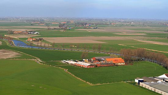
The Haringvliet (often referred to as the Haring Estuary) is a freshwater channel located in the southwestern Netherlands. It serves as a distributary of the…
What is Haring Estuary?
The Haringvliet (often referred to as the Haring Estuary) is a freshwater channel located in the southwestern Netherlands. It serves as a distributary of the Hollands Diep, originating from the Lower Rhine (Neder Rijn) River. The channel flows for approximately 20 miles (32 km), separating the islands of Voorne-Putten and Beijerland to the north from Goeree-Overflakkee to the south, before discharging into the North Sea.1
Following the devastating tidal surge floods of February 1953, the area became a key component of the Delta Plan. To enhance land reclamation efforts and provide critical flood protection against the Rhine and the sea, a dam equipped with numerous sluices was completed at the mouth of the channel in 1970. A large lock was also constructed within the dam to ensure the waterway remains accessible to shipping traffic.1
What was the Delta Plan in the Netherlands?
The Delta Works (often referred to as the Delta Plan) is a massive flood-control project in the southwestern Netherlands designed to protect the region from the North Sea. Devised by engineer Johan van Veen, the project gained critical urgency following a catastrophic flood on February 1, 1953, which claimed 1,836 lives and devastated vast areas of land.23
The project involved closing off the Rhine, Meuse, and Schelde estuaries using a system of 13 dams. By linking various islands, the plan shortened the vulnerable coastline by 700 km (435 miles), significantly reducing the length of dikes exposed to the sea.23
Key features include:
- Freshwater Conversion: The dams transformed tidal inlets into freshwater lakes, preventing salt contamination of agricultural land.23
- Oosterscheldedam: This final barrier features adjustable gates that allow tidal flow to support local ecosystems while remaining capable of closing during severe storms.2
- Infrastructure: The project integrated new roadways and bridges, ending the historic isolation of the region.2
Recognized as one of the Seven Wonders of the Modern World, the Delta Works remains a landmark achievement in land reclamation and maritime engineering.23
How do dams and sluices prevent flooding?
Dams and sluices are essential components of hydraulic engineering used to manage water levels and mitigate the risk of flooding.
The Role of Dams and Reservoirs
Dams function by impounding water in reservoirs, which allows for the storage of excess runoff during periods of heavy rainfall or snowmelt. By controlling the volume of water released downstream, dams help prevent the river from exceeding its banks. However, their effectiveness is limited by capacity; once a reservoir is full, it can no longer store additional water, necessitating the release of incoming flow.45
The Function of Gates and Sluices
Floodgates and sluices are movable barriers used to regulate the passage of water through or over a dam. They serve several critical purposes:6
- Spillway Management: Gates direct excess water away from the dam and its foundation, preventing erosion that could lead to structural failure.7
- Flow Control: Various designs, such as vertical-lift, radial, and drum gates, allow engineers to precisely control the water level upstream.78
- Diversion: During extreme flood events, sluiceways and floodways can be opened to divert excess water into designated reservoirs or floodplains, protecting vulnerable downstream areas.4
What are the environmental impacts of land reclamation?
Land reclamation involves significant environmental impacts, as it fundamentally alters natural landscapes to suit human needs. While these projects aim to improve land for agriculture, housing, or industry, they often disrupt existing ecosystems and hydrological processes.121314
Key Environmental Consequences
- Habitat Disruption: The diking and draining of tidal marshes or the clearing of tropical lands removes native vegetation and displaces local wildlife.1213
- Hydrological Alterations: Engineering modifications, such as channel straightening and the construction of large dams, drastically change river flow patterns and convert natural valleys into lakes.15
- Subsidence and Soil Issues: The removal of groundwater for development can lead to land subsidence and collapse. Furthermore, reclamation of abandoned lands often requires managing salt accumulation, which can affect water quality if not properly drained.1315
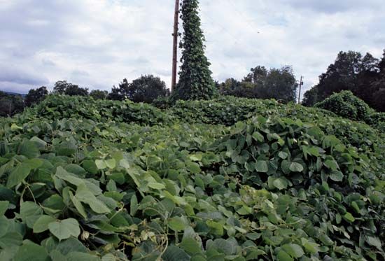
- Invasive Species Risks: Past efforts to stabilize eroded land have sometimes introduced invasive species, such as kudzu in the United States, which can overrun native plants and cause long-term ecological damage.16
In the 21st century, there is an increasing shift toward prioritizing sustainability and environmental health alongside economic development when planning these projects.16
Sources
- Haring Estuary — Encyclopædia Britannica
- Delta Works — Encyclopædia Britannica
- Harbors and sea works - The Delta Works — Encyclopædia Britannica
- floodgate — Encyclopædia Britannica
- gate — Encyclopædia Britannica
- Mississippi River - Flood control — Encyclopædia Britannica
- sluice gate — Merriam-Webster
- levee — Encyclopædia Britannica
- flood — Encyclopædia Britannica
- dam - Gates — Encyclopædia Britannica
- sluice — Merriam-Webster
- land reclamation — Encyclopædia Britannica
- Drainage - Land reclamation — Encyclopædia Britannica
- biogenic landform — Encyclopædia Britannica
- coal mining - Reclamation equipment — Encyclopædia Britannica
- land reclamation - Reclamation of eroded, infertile, and “new” lands — Encyclopædia Britannica
- United States - Climate — Encyclopædia Britannica
Published on · 3 min read