Hernád River
The Hernád River is a river located in Slovakia and Hungary. It originates on the northern slopes of the Low Tatra (Nízke Tatry) mountains in Slovakia. The…
What is Hernád River?
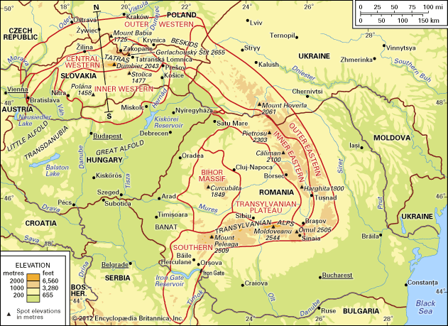
The Hernád River is a river located in Slovakia and Hungary. It originates on the northern slopes of the Low Tatra (Nízke Tatry) mountains in Slovakia. The river flows in an eastward and then southward direction for approximately 165 miles (265 km) before joining the Sajó River, which is a tributary of the Tisza River.1
What are the Low Tatra mountains like?
The Low Tatra (Nízke Tatry) mountains are a prominent range within the Central Western Carpathians in Slovakia. Situated south of the High Tatra range and separated by the Liptov and Spiš basins, the Low Tatras run parallel to their higher neighbors.23
Key characteristics of the Low Tatra range include:
- Elevation and Relief: The mountains reach elevations of approximately 6,500 feet (2,000 meters), with Ďumbier Peak serving as the highest point at 6,703 feet (2,043 meters). While they share a similar geologic structure to the High Tatras, they exhibit a less conspicuous glacial relief.423
- Geology: The range is primarily built of crystalline (granite) and metamorphic rocks.3
- Climate and Environment: As part of Slovakia’s mountainous terrain, the region experiences a continental climate with significant variations in temperature and precipitation based on altitude. The mountains contribute to the country’s diverse topography, which is defined by a system of east-west-trending ranges.52
How does the Tisza River impact the region?
The Tisza River plays a vital role in the landscape and economy of eastern Hungary, though it has historically posed significant challenges to the region.
Flood Dynamics and Control
The river is characterized by dramatic fluctuations in water levels due to the lack of stabilizing lakes in the Carpathian Mountains. These variations result in three annual floods, which can be devastating when they coincide with high water in the Danube River. To mitigate these risks, the region has developed an extensive infrastructure of approximately 2,400 to 2,500 miles of flood-control levees.78
Economic and Agricultural Impact
The Tisza is essential for the development of the Great Alfold (Great Hungarian Plain):
- Irrigation: Large-scale irrigation systems, supported by the Tiszalök Dam and various canals, provide necessary water to the relatively dry plains of Hajdúság and Hortobágy.78
- Energy and Transport: The Tiszalök Dam generates hydroelectric power, and the river serves as a navigable waterway for boats up to Szolnok, which functions as a key river port alongside Csongrád and Szeged.7
What are the main tributaries of the Danube River?
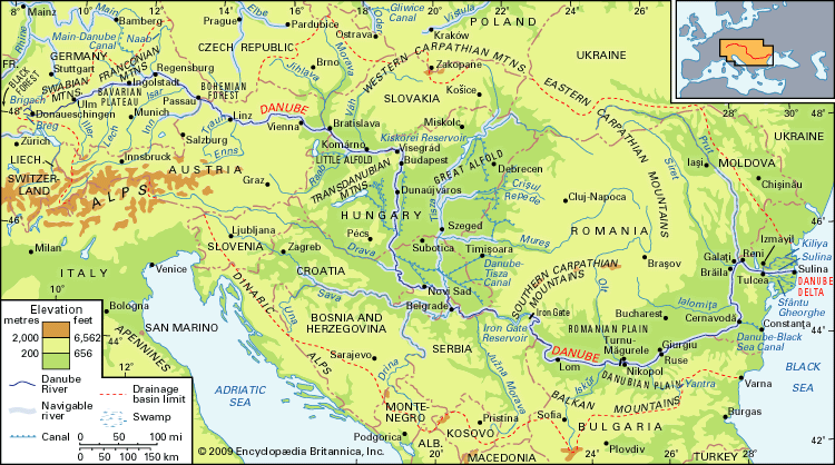
The Danube River features a dense network of approximately 300 tributaries, with more than 30 being navigable. These tributaries are essential to the river’s flow, with right-bank tributaries—collecting water from the Alps and other mountain regions—contributing up to two-thirds of the total runoff.9
Major tributaries are categorized by the river’s course:
- Upper Course: Key tributaries include the Inn River—the largest upstream tributary—as well as the Iller, Lech, Isar, Traun, Enns, and Morava rivers.9
- Middle Course: This section receives the river’s most affluent tributaries, which significantly alter its regime: the Drava, the Tisza, and the Sava.9
- Lower Course: Tributaries in this section are comparatively smaller and include the Olt, the Siret, and the Prut.9
Sources
- Hernád River — Encyclopædia Britannica
- Tatra Mountains — Encyclopædia Britannica
- Slovakia - Relief — Encyclopædia Britannica
- Carpathian Mountains - Physiography of the Carpathian Mountains — Encyclopædia Britannica
- Slovakia - Climate — Encyclopædia Britannica
- Carpathian Mountains - Tourism — Encyclopædia Britannica
- Tisza River — Encyclopædia Britannica
- Hungary - Drainage and soils — Encyclopædia Britannica
- Danube River - Physiography — Encyclopædia Britannica
- Danube River — Encyclopædia Britannica
Published on · 2 min read