Hofsjökull
Hofsjökull is a large glacier located in central Iceland. It covers a circular area of approximately 384 square miles (994 square km) and spans nearly 25…
What is Hofsjökull?
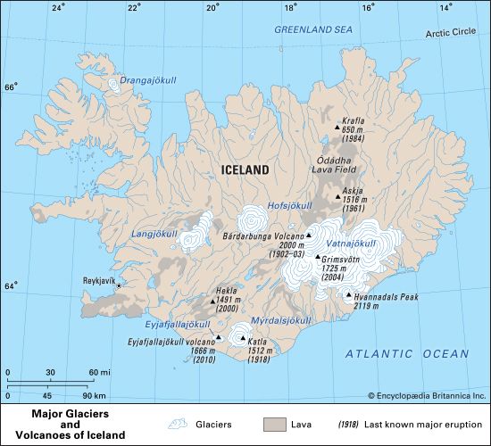
Hofsjökull is a large glacier located in central Iceland. It covers a circular area of approximately 384 square miles (994 square km) and spans nearly 25 miles (40 km) in diameter.1
The glacier reaches an elevation of 5,791 feet (1,765 metres) at its center. Its meltwaters are a vital source for several rivers, including the Héradhsvötn, Thjórsá, Ölfusá, and Blanda.1
How do glaciers shape the landscape of Iceland?
Glaciers have played a fundamental role in shaping Iceland’s geologically young landscape through powerful processes of erosion and sediment transport.
Erosional Landforms
The most prominent features created by glacial activity are the island’s characteristic U-shaped valleys. These were carved by the immense weight and movement of glaciers, which acted as abrasive systems, grinding down bedrock and deepening valleys over thousands of years. Where these glaciated valleys meet the coast, they have been submerged by the sea to form fjords, which are often exceptionally deep due to the intense erosive power of the ice that once occupied them.2345
Hydrological Impact
Glaciers also dictate the island’s drainage patterns:
- River Systems: Many of Iceland’s rivers are debris-laden streams of glacial origin. These rivers often exhibit braided-channel patterns, a result of the high sediment load and fluctuating water discharge typical of melting glaciers.56
- Lakes: Glacial ice frequently acts as a natural dam, creating lakes in the landscape.5
- Catastrophic Floods: The sudden drainage of subglacial lakes, known as jökulhlaups, can cause massive, landscape-altering floods that reshape river valleys and deposit significant amounts of sediment.6
What are the largest glaciers in Iceland?
Iceland is home to five major ice caps that significantly shape its landscape. The largest of these is Vatnajökull (Vatna Glacier), an extensive ice field in southeastern Iceland covering more than 3,000 square miles (approximately 8,000–8,400 square km).6893
Vatnajökull is remarkably large, with an area equal to the combined total of all glaciers on the continent of Europe. It reaches an average ice thickness of more than 3,000 feet (900 meters) and contains the country’s highest peak, Hvannadals Peak, which rises to 6,952 feet (2,119 meters). The ice field also conceals several active volcanoes, including Grímsvötn, which periodically trigger catastrophic glacial floods known as jökulhlaups.8936
While Vatnajökull is the most prominent, Iceland features four other major ice caps that rely on heavy snowfall for their survival. These glaciers, along with the rest of the country’s ice, cover approximately one-tenth of Iceland’s total land area.68
How does volcanic activity affect Icelandic glaciers?
Volcanic activity significantly alters Icelandic glaciers through intense heat, which triggers melting and creates unique geological hazards. Because many of Iceland’s volcanoes are located beneath thick ice caps, the interaction between rising magma and glacial ice is a defining feature of the landscape.6109
Glacial Outburst Floods
The most frequent impact of subglacial volcanic activity is the generation of jökulhlaups, or glacier outburst floods. When a volcano like Grímsvötn erupts, it melts the surrounding ice, creating a subglacial lake. As water accumulates, it eventually breaches the ice walls, releasing massive volumes of water and sediment downstream with catastrophic force.1110
Explosive Eruptions and Ash
When magma contacts glacial ice, the rapid vaporization of water can lead to explosive eruptions. This process creates plumes of steam and ash that can disrupt regional travel, as seen during the 2010 eruption of Eyjafjallajökull. Additionally, the sudden melting of ice can trigger lahars—volcanic mudflows—that carry vast amounts of debris, which can permanently reshape coastal areas and river valleys.69
Sources
- Hofsjökull — Encyclopædia Britannica
- Iceland - Lakes and rivers of Iceland — Encyclopædia Britannica
- Iceland - Relief — Encyclopædia Britannica
- fjord — Encyclopædia Britannica
- glacial landform - Glacial erosion — Encyclopædia Britannica
- Iceland - Land — Encyclopædia Britannica
- Pleistocene Epoch - Fluvial environments — Encyclopædia Britannica
- Arctic - Other glacier groups — Encyclopædia Britannica
- Vatnajökull — Encyclopædia Britannica
- glacier - Glacier floods — Encyclopædia Britannica
- Katla — Encyclopædia Britannica
Published on · 3 min read