Java Trench
The Java Trench serves as a critical subduction zone along the boundary of the Indo-Australian Plate. At this location, the seafloor of the Indo-Australian…
How does the Java Trench relate to the broader Indo-Australian Plate boundary?
The Java Trench serves as a critical subduction zone along the boundary of the Indo-Australian Plate. At this location, the seafloor of the Indo-Australian Plate is being forced beneath the stable Sunda Shelf and the Sunda Island arc.1
This tectonic interaction is highly active, characterizing the region as a zone of significant volcanic and seismic activity. The ongoing subduction process is responsible for the trench’s extreme depth, which reaches 24,440 feet (7,450 meters) at its deepest point. The geological instability of this boundary is evidenced by major events, such as the 2004 magnitude 9.1 earthquake, which occurred along the fault zone associated with this subduction. While the Indian-Australian Plate’s northern edge is also involved in the collision forming the Himalayas, the Java Trench specifically marks the oceanic boundary where the plate descends into the mantle.123
How deep is the Java Trench and how does it compare to other ocean trenches?
The Java Trench is a deep submarine depression in the eastern Indian Ocean that reaches a maximum depth of 24,440 feet (7,450 meters), representing the deepest point in that ocean. Other sources cite a slightly greater depth of 25,344 feet (7,725 meters).12
When compared to other deep-sea trenches, the Java Trench shares the characteristic V-shaped structure and association with subduction zones common to most major trenches. While typical trench depths globally range from 8 to 10 km (5 to 6 miles), the Java Trench is notable for its role as the primary subduction zone in the Indonesian region, stretching approximately 2,000 miles (3,200 km). Unlike some trenches that are heavily buried by sediment, such as parts of the Aleutian Trench, the Java Trench remains a highly active volcanic and seismic feature. It is distinct from oceanic troughs, which are generally shallower, narrower, and formed by a wider variety of geological mechanisms.5617
What is the Java Trench and where is it located in the Indian Ocean?
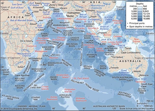
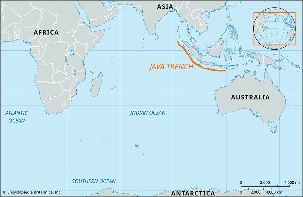
The Java Trench is a deep submarine depression located in the eastern Indian Ocean. It extends approximately 2,000 to 2,800 miles (3,200 to 4,500 km) in a northwest-southeast arc, situated about 190 miles (305 km) off the southwestern coasts of Sumatra and Java, and continues eastward south of the western Sunda Islands.11
As an extensive subduction zone, the trench marks the boundary where the seafloor of the tectonic plate to the west is forced beneath the Sunda Shelf and the Sunda Island arc. This region is highly active, characterized by significant volcanic and seismic activity, including the massive 2004 magnitude 9.1 earthquake. Reaching a maximum depth of 24,440 feet (7,450 meters), it is the deepest point in the Indian Ocean.81
What scientific research and exploration have been conducted in the Java Trench?
Scientific research and exploration of the Java Trench have been part of broader, systematic investigations of the Indian Ocean. Following the pioneering work of the British naval vessel Challenger in 1872, numerous international expeditions have contributed to our understanding of this region.1
Key research efforts include:
- Post-World War II Expeditions: Voyages by the Danish Galathea, the Swedish Albatross, and the British Challenger II explored the northern Indian Ocean, providing early data on its deep-sea features.1
- International Cooperation: The International Indian Ocean Expedition (1960–65) involved approximately three dozen research ships, significantly advancing knowledge of the ocean’s marine geology and geophysics.1
- Deep Sea Drilling: Several legs of the Deep Sea Drilling Project (1968–83) were conducted in the Indian Ocean, offering insights into the seafloor and resource potential.1
- Geophysical and Seismic Studies: Because the Java Trench is a major subduction zone, it has been the subject of intense seismic monitoring, particularly following the massive 2004 earthquake. Research in this area utilizes gravity measurements and seismological data to understand how the lithosphere descends into the asthenosphere.926
Modern research continues to integrate satellite photography and advanced technology to monitor climate change and map the complex geological structures of the trench, including its accretionary prism.14
Sources
- Java Trench — Encyclopædia Britannica
- Java Trench — Merriam-Webster
- India - Relief — Encyclopædia Britannica
- Indian Ocean - Trenches — Encyclopædia Britannica
- deep-sea trench - Types — Encyclopædia Britannica
- deep-sea trench - Origin of deep-sea trenches — Encyclopædia Britannica
- oceanic trough — Encyclopædia Britannica
- deep-sea trench - Structure — Encyclopædia Britannica
- Indian Ocean - Systematic investigations — Encyclopædia Britannica
- Java Sea — Encyclopædia Britannica
Published on · 3 min read