Juruá River
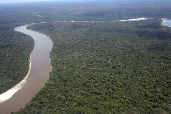
The Juruá River is a major river in the Amazon basin and is recognized as the most winding river in the region. It originates in the highlands east of the…
What is Juruá River?
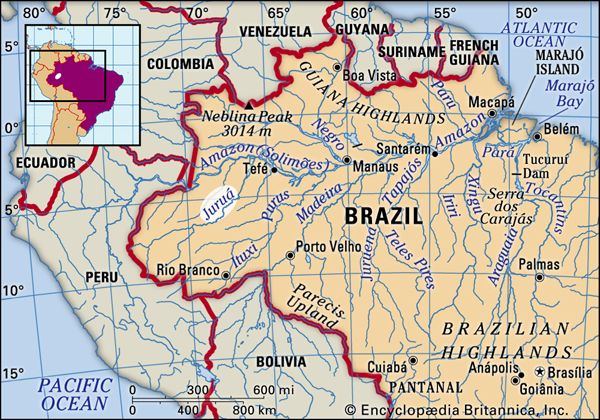
The Juruá River is a major river in the Amazon basin and is recognized as the most winding river in the region. It originates in the highlands east of the Ucayali River in east-central Peru and flows northward through the Brazilian state of Acre before meandering through Amazonas to join the Solimões (the upper stretch of the Amazon River).1
Spanning over 2,040 miles (3,283 km) in length, the Juruá is classified as a “whitewater” river because it originates in the tectonically active Andes, where it collects heavy sediment loads. Despite its great length, it descends from a relatively low elevation of 1,486 feet (453 meters) above sea level. The river is navigable for more than 600 miles (950 km) above its junction with the Amazon, though its banks remain sparsely inhabited.12
What makes the Juruá River the most winding river in the Amazon basin?
The Juruá River is considered the most winding river in the Amazon basin primarily due to the extreme disparity between its length and its elevation change.
The river spans a total length of more than 2,040 miles (3,283 km), yet it descends from an elevation of only 1,486 feet (453 meters) above sea level. This very gradual slope forces the river to meander extensively across the landscape as it flows northward through Acre and Amazonas states before joining the Solimões River.1
As a “whitewater” river originating in the tectonically active Andes, the Juruá carries heavy sediment loads that contribute to the dynamic nature of its floodplain. Like other rivers in the region, it frequently swings across its alluvium, a process that can undercut banks and create the “fallen land” (terra caída) characteristic of the basin’s meandering watercourses.2
How do whitewater rivers like the Juruá differ from blackwater rivers?
In the Amazon basin, rivers are categorized by their source, sediment load, and chemical composition. The differences between whitewater rivers, such as the Juruá, and blackwater rivers, such as the Negro, are distinct:4
- Origin and Sediment: Whitewater rivers originate in the geologically youthful and tectonically active Andes. As they flow from these mountains, they collect heavy loads of silt and dissolved solids, which give the water a turbid, yellowish appearance. In contrast, blackwater rivers rise in ancient, nutrient-poor crystalline highlands and sandy uplands, resulting in water that carries little to no silt.24
- Chemical Composition: Blackwater rivers are characterized by high levels of humic acids, which are produced by the decomposition of organic matter in marginal swamps. These acids are responsible for the river’s signature jet-black color. Whitewater rivers, conversely, have a higher mineral content due to their Andean origins.24
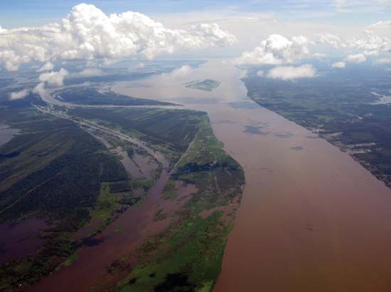
When these two types of water meet, such as at the confluence of the Amazon and the Negro at Manaus, they do not mix immediately, often creating a visible color boundary.4
What are the main differences between the varzea and terra firme landscapes in the Amazon?
The primary distinction between várzea and terra firme landscapes in the Amazon basin lies in their relationship to flooding and soil composition.
Várzea (Inundated Forests)
Várzea refers to the floodplains associated with whitewater rivers. These areas are characterized by:
- Periodic Inundation: They are subject to annual flooding, which creates a dynamic mosaic of lakes, marshes, and natural levees.6
- Soil Fertility: These soils are highly fertile because they are rejuvenated each year by nutrient-rich silt deposits left behind as floodwaters recede.56
- Human Settlement: Due to this natural fertilization, várzea areas and their margins are the most attractive locations for human settlement and agricultural activity, though usage is limited by the cycle of inundation.57
Terra Firme (Upland Forests)
Terra firme (“solid ground”) constitutes more than two-thirds of the Amazon basin and consists of forests that do not flood. Key features include:86
- Topography: These are generally gently undulating hills composed of alluvial soil deposited millions of years ago and subsequently uplifted above flood level.8
- Soil Quality: Unlike the nutrient-rich várzea, terra firme soils are typically well-drained, porous, and acidic. They often lack essential nutrients like nitrogen, phosphate, and potash.59
- Nutrient Cycling: The lush vegetation of the terra firme relies on a delicate, closed-loop system where nutrients are locked in the biomass and recycled through the rapid decay of leaf litter. If the forest canopy is destroyed, this cycle is interrupted, and the soil quickly loses its fertility.59
Sources
- Juruá River — Encyclopædia Britannica
- Amazon River - Physiography of the river course — Encyclopædia Britannica
- Japurá River — Encyclopædia Britannica
- Negro River — Encyclopædia Britannica
- Amazon River - Soils of the Amazon River — Encyclopædia Britannica
- Amazon River - Plant life — Encyclopædia Britannica
- Brazil - Amazon lowlands — Encyclopædia Britannica
- Brazil - Soils — Encyclopædia Britannica
- Amazon basin — Encyclopædia Britannica
Published on · 3 min read