Katsina Ala River
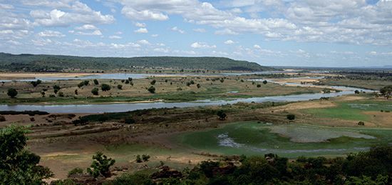
The Katsina Ala River is a waterway in western Africa that originates northeast of Bamenda, Cameroon. It flows northwest for approximately 200 miles (320…
What is Katsina Ala River?
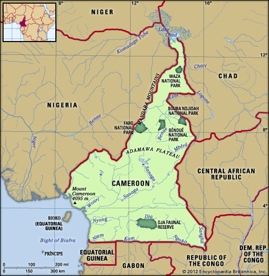
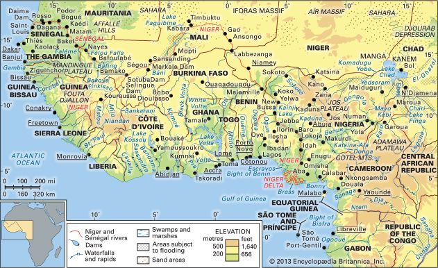
The Katsina Ala River is a waterway in western Africa that originates northeast of Bamenda, Cameroon. It flows northwest for approximately 200 miles (320 km), entering eastern Nigeria north of Gayama.1
The river passes the town of Katsina Ala and eventually joins the Benue River northeast of Abinsi. It is navigable for a stretch of 90 miles (145 km) downstream from the town of Katsina Ala.1
What is the importance of the Benue River in Nigeria?
The Benue River is vital to Nigeria’s economy and infrastructure as the longest tributary of the Niger River. Its importance is defined by several key roles:23
- Transportation and Trade: The river serves as a significant waterway for commercial shipping. It facilitates the transport of imports, such as petroleum, and exports, including cotton and peanuts, from the Chad region. Its influx of water is also critical for maintaining navigable depths in the Niger River downstream from their confluence at Lokoja.24
- Infrastructure: The river is crossed by essential road and railway bridges, notably at Makurdi, as well as at Numan and Yola, which support regional connectivity.4
- Resource Management: Along with the Niger, the Benue is a central component of the Niger-Benue basin, which is utilized for agriculture, power generation, and fishing projects managed by various river basin development authorities fishing projects managed by various river basin development authorities.34
Unlike the Niger, the Benue is largely uninterrupted by rapids or waterfalls within Nigeria, making it navigable throughout its length, subject to seasonal water levels.23
How does the geography of Cameroon influence its rivers?
The geography of Cameroon, characterized by its diverse relief and climate, dictates the flow and distribution of its four major drainage systems.6
- Topographic Influence: The country’s varied relief—ranging from coastal plains and the central Adamawa Plateau to the mountainous western highlands—determines the direction of river flow. Rivers in the south, such as the Sanaga, Wouri, Nyong, and Ntem, drain into the Atlantic Ocean. In the north, the terrain slopes toward the Lake Chad basin, directing the Logone and Chari rivers northward.76
- Climatic Impact: Precipitation patterns, which decrease significantly from the wet south to the arid north, influence river volume and seasonality. The heavy rainfall in the western highlands and southern forests sustains perennial flow, while the northern regions experience more seasonal fluctuations.8
- Geological Features: The presence of mountainous terrain and plateaus creates falls and rapids, such as those on the Sanaga River, which are harnessed for hydroelectric power.9
What are the main uses of navigable rivers in West Africa?
Navigable rivers in West Africa serve as critical arteries for the region, supporting a variety of economic and infrastructural needs. Their primary uses include:
- Commercial Transportation: Rivers such as the Niger River and the Gambia River are vital for moving passengers, mail, and freight. The Gambia River is particularly notable as one of the few West African waterways easily accessible to oceangoing shipping, serving as the primary transport artery for its namesake nation. On the Niger and Benue rivers, large vessels transport significant quantities of goods, including petroleum, cotton, and peanuts.4112
- Energy Production: Many rivers are harnessed for hydroelectric power. Dams such as the Kainji Dam on the Niger and various hydroelectric plants on the Konkouré River provide essential electricity for industrial activities, including bauxite processing.121314
- Agriculture and Irrigation: River systems are central to large-scale irrigation projects designed to support the cultivation of crops like rice, sugarcane, and vegetables. These projects are managed by various river basin authorities to transform valleys into productive agricultural corridors.41314
- Fishing: River fishing is a specialized and essential occupation, providing a food source and economic activity, particularly during the dry season when coastal catches are limited.151611
Sources
- Katsina Ala River — Encyclopædia Britannica
- Benue River — Encyclopædia Britannica
- Nigeria: Top Questions — Encyclopædia Britannica
- Niger River - Transportation — Encyclopædia Britannica
- Nigeria - Drainage — Encyclopædia Britannica
- Cameroon - Drainage — Encyclopædia Britannica
- Cameroon - Relief — Encyclopædia Britannica
- Cameroon - Climate of Cameroon — Encyclopædia Britannica
- Sanaga River — Encyclopædia Britannica
- history of Cameroon — Encyclopædia Britannica
- Konkouré River — Encyclopædia Britannica
- Niger River - People and economy — Encyclopædia Britannica
- Niger River - Irrigation — Encyclopædia Britannica
- Senegal - Agriculture, forestry, and fishing — Encyclopædia Britannica
- Africa - Availability for human use — Encyclopædia Britannica
- Gambia River — Encyclopædia Britannica
Published on · 3 min read