Mount Hermon
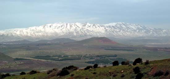
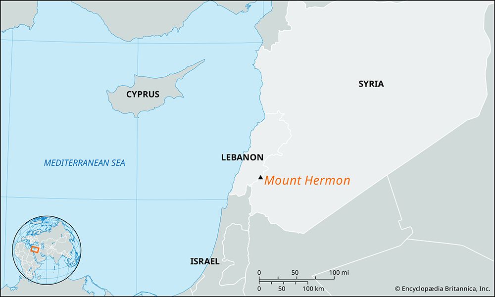
Mount Hermon is a prominent, snowcapped ridge situated on the border between Lebanon and Syria, located west of Damascus. Reaching an elevation of 9,232 feet…
What is Mount Hermon?
Mount Hermon is a prominent, snowcapped ridge situated on the border between Lebanon and Syria, located west of Damascus. Reaching an elevation of 9,232 feet (2,814 meters), it serves as the highest point along the eastern coast of the Mediterranean Sea and is often identified as the southernmost extension of the Anti-Lebanon range.12
The mountain is historically significant as the source of the Jordan River and has been regarded as a sacred landmark since the Bronze Age. In biblical tradition, it marked the northwestern boundary of the Israelite conquest led by Moses and Joshua. Following the Six-Day War in 1967, a portion of the mountain’s southern and western slopes became part of the Israeli-administered Golan Heights, where the area has since been developed for recreational activities, including skiing.1
How does Mount Hermon influence the water supply of the Jordan River?
Mount Hermon serves as the critical hydrological foundation for the Jordan River, as all three of the river’s principal sources rise at the mountain’s foot. These sources include:3
- The Ḥāṣbānī River: The longest of the three, which rises in Lebanon near Ḥāṣbayyā.3
- The Bāniyās River: Which flows from the east in Syria.3
- The Dan River: The largest of the three tributaries, which is fed by rain and snowmelt that percolate through the rock of Mount Hermon before emerging as hundreds of springs3.1
The mountain’s influence is primarily driven by its capacity to capture precipitation, which then filters through its geological structure to feed these springs. Once these three rivers emerge at the base of the mountain, they join together in the Ḥula Valley to form the main course of the Jordan River.13
What role does Mount Hermon play in the geography of the Golan Heights?
Mount Hermon serves as the northern geographic boundary of the Golan Heights. While the Golan is generally characterized as a hilly area, the northern portion is defined by the stony foothills of the mountain, which feature patches of woodland and scrub and are primarily utilized for stock-raising.15
The influence of Mount Hermon on the region is both physical and political. Geographically, the Israeli-administered portion of the Golan reaches its highest elevation of 7,297 feet (2,224 meters) at the extreme northeast point on the slopes of Mount Hermon. Politically, following the Six-Day War in 1967, approximately 40 square miles (100 square km) of the mountain’s southern and western slopes were incorporated into the Israeli-administered Golan Heights. These slopes have since been developed for recreational use, most notably for skiing.16
Why was Mount Hermon considered a sacred site in the Bronze Age?
Mount Hermon has been recognized as a sacred landmark since the Bronze Age, though the specific theological or cultural reasons for this status are not detailed in the available records. Its historical significance is further underscored by its role as the northwestern boundary of the Israelite conquest led by Moses and Joshua.1
The mountain’s enduring religious importance is evidenced by the presence of temples on its slopes, which contain Greek inscriptions dating back to approximately 200 ce, suggesting that the site remained a center of worship long after the Bronze Age.1
We could dive deeper into the archaeological findings at these temple sites or explore the historical significance of the mountain in ancient Near Eastern mythology.
Sources
- Mount Hermon — Encyclopædia Britannica
- Hermon, Mount — Merriam-Webster
- Jordan River — Encyclopædia Britannica
- Dan River — Encyclopædia Britannica
- Golan Heights — Encyclopædia Britannica
- Golan Heights: Top Questions — Encyclopædia Britannica
Published on · 3 min read