Mountains of Perijá
The Mountains of Perijá (Serranía del Perijá) constitute a mountain chain that serves as the northward extension of the Andean Cordillera Oriental. This…
What is Mountains of Perijá?
The Mountains of Perijá (Serranía del Perijá) constitute a mountain chain that serves as the northward extension of the Andean Cordillera Oriental. This range forms a significant portion of the border between Colombia and Venezuela.1
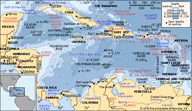
Stretching approximately 190 miles (306 km), the range runs from the vicinity of Ocaña, Colombia, northward to the Guajira Peninsula. Its crest line reaches elevations of up to 12,300 feet (3,750 metres) above sea level. The range encompasses several distinct mountain groups, including the Motilones, Valledupar, and Oca mountains. Geographically, the range is situated east of the Sierra Nevada de Santa Marta—separated by the César River—and west of the Maracaibo Lowland in Venezuela.1
How do the Andes Mountains influence the climate of South America?
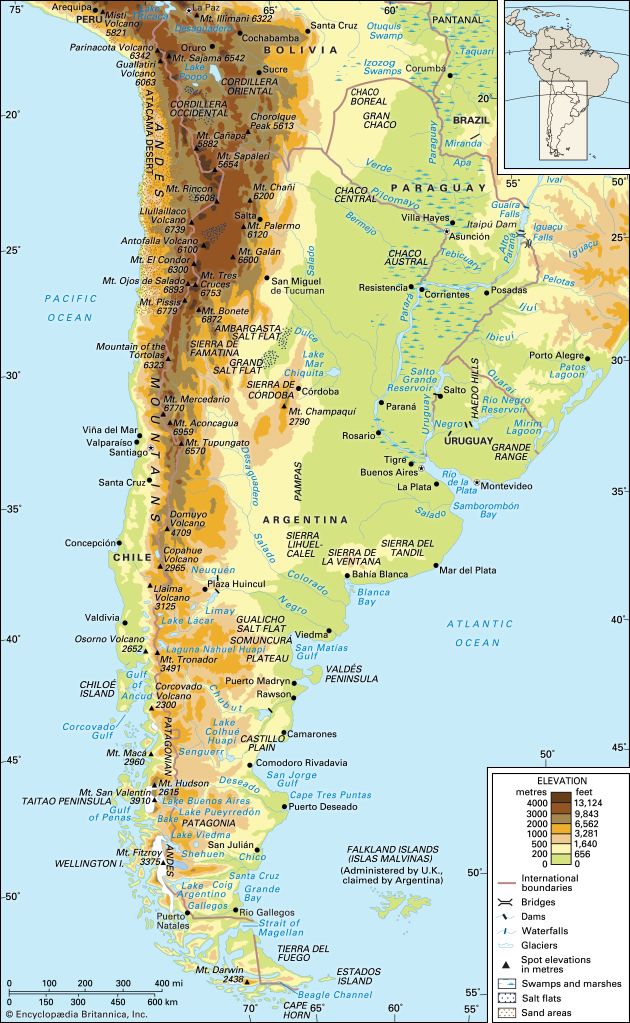
The Andes Mountains exert a profound influence on the climate of South America by acting as a massive orographic barrier that dictates patterns of precipitation and temperature across the continent.34
Precipitation and Rain Shadows
The Andes significantly alter moisture distribution by forcing air masses to rise, which results in orographic precipitation on windward slopes. As moist air ascends, it releases most of its water, leaving the leeward side of the mountains significantly drier. This process creates a vast rain shadow over much of the southern tier of the continent, contributing to the arid conditions of Patagonia. Similarly, in the north, the Andes act as a natural barrier that prevents moisture from leaving the Amazon Basin, resulting in high levels of rainfall on the eastern flanks.345
Vertical Climatic Zones
The mountains create distinct vertical climatic zones, where temperature and vegetation change rapidly with altitude. These zones include:36
- Tierra caliente: Humid and warm conditions at the base.3
- Tierra templada: Temperate and semi-humid mid-levels, which support major agricultural centers.36
- Tierra fría: Cool and dry highlands.3
- Tierra helada: Cold to freezing glacial summits.3
Atmospheric Flow
As a north-south barrier, the Andes influence atmospheric circulation by blocking mid-latitude westerlies. This forces air to move poleward or toward the Equator, effectively acting as a high-pressure center that shapes regional weather patterns.4
What is the significance of the Sierra Nevada de Santa Marta?
The Santa Marta Mountains, or Sierra Nevada de Santa Marta, are a significant volcanic massif in northern Colombia that rise abruptly from the Caribbean Sea. Their primary geographical significance lies in their extreme elevation; the range culminates in Pico Cristóbal Colón, which, at 18,947 feet (5,775 meters), is the highest peak in the country.7
Beyond their physical stature, the mountains hold profound cultural and historical importance. They are home to Arawak Indigenous peoples and contain Teyuna, also known as the “Lost City.” Dating back to approximately 800 CE, this ancient settlement is a vital site for the descendants of the Tairona people. The region’s rich heritage is further preserved through artifacts found in the area, which are showcased in institutions like the Museum of Gold in the nearby city of Santa Marta. While the lower slopes are utilized for agriculture and livestock, the range remains a critical landmark of both natural biodiversity and pre-Hispanic history.78
What are the main characteristics of the Maracaibo Lowland?
The Maracaibo Lowlands, located in northwestern Venezuela, are a distinct physiographic region situated between the Perijá Mountains and the Cordillera de Mérida branches of the Andes Mountains.10
Key characteristics of the region include:
- Central Water Body: The basin is dominated by Lake Maracaibo, a large, shallow inlet of the Caribbean Sea. While its southern waters are fresh, the northern portion is brackish due to tidal influence from the Gulf of Venezuela.1112
- Economic Significance: The region is one of the world’s most important petroleum-producing areas. Since the discovery of oil in 1917, the basin has supplied approximately two-thirds of Venezuela’s total petroleum output, with extensive infrastructure including derricks and underwater pipelines.1210
- Vegetation: The landscape varies significantly by location. The southern basin is characterized by dense tropical rainforest, while the areas closer to the Caribbean feature xerophytic scrub woodland and grasses.13
- Topography: The basin is surrounded by swampy lowlands and higher mountain ranges that exclude steady trade winds, contributing to high temperatures and humidity in the region.1214
Sources
- Mountains of Perijá — Encyclopædia Britannica
- list of mountain ranges - South America — Encyclopædia Britannica
- South America - Factors influencing climate — Encyclopædia Britannica
- Amazon River - Climate — Encyclopædia Britannica
- Andes Mountains - Plant and animal life — Encyclopædia Britannica
- Atmosphere - Mountain barriers — Encyclopædia Britannica
- Santa Marta Mountains — Encyclopædia Britannica
- Sierra Nevada de Santa Marta — Merriam-Webster
- Santa Marta — Encyclopædia Britannica
- Venezuela - Drainage of Venezuela — Encyclopædia Britannica
- Lake Maracaibo — Encyclopædia Britannica
- Maracaibo — Encyclopædia Britannica
- Venezuela - Flora — Encyclopædia Britannica
- Venezuela - Relief — Encyclopædia Britannica
Published on · 3 min read