Mulanje Mountains
The Mulanje Mountains are characterized by an almost rectangular mass composed of syenite, an intrusive igneous rock. Geologically, the massif is defined by…
What is the geological history of the Mulanje Mountains?
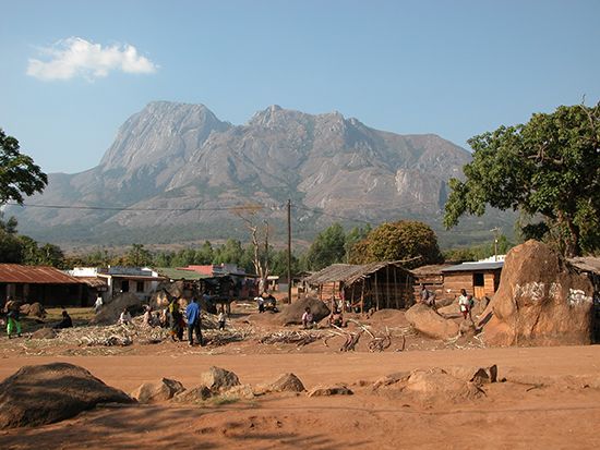
The Mulanje Mountains are characterized by an almost rectangular mass composed of syenite, an intrusive igneous rock. Geologically, the massif is defined by its distinct erosional features, which include high-altitude plateaus, deep, narrow clefts, and crater-like hollows.1
The mountains are classified as an isolated massif, rising abruptly from the surrounding plateau. Notably, the outliers of the range, such as Mchese to the northeast and Chambe to the northwest, are identified as eroded ring structures. These formations are part of the broader landscape of Malawi, which features various highlands and isolated massifs that contrast with the country’s dominant East African Rift System.12
What is the highest peak in the Mulanje Mountains and how tall is it?
The highest peak in the Mulanje Mountains is Mulanje Peak, which reaches an elevation of 9,848 feet (3,002 meters). It serves as the highest point in Malawi.12
Where are the Mulanje Mountains located in Malawi?
The Mulanje Mountains are located in the Mulanje District of southeastern Malawi. This isolated massif rises abruptly from the surrounding plateau and overlooks the Lake Chilwa–Phalombe Plain to the northeast. Geographically, the mountains are situated in the southern part of the country, surmounting the Shire Highlands and positioned near the border with Mozambique.124
How does the climate vary at different elevations in the Mulanje Mountains?
The climate in the Mulanje Mountains varies significantly with elevation, primarily characterized by a decrease in temperature as altitude increases. While the region experiences a general dry season from May to October and a wet season from November to April, the upper levels of the massif are notably cooler, with frosts occurring in July.5
Precipitation patterns also show a strong correlation with elevation. The highest annual rainfall is recorded on the Sapitwa peak of the Mulanje massif, reaching approximately 90 inches (2,300 mm). This is substantially higher than the precipitation levels found in the lower-lying areas of the country, such as the Shire valley, which typically receive between 25 and 35 inches (650 to 900 mm) of rain. These climatic conditions support diverse vegetation, including the unique Mulanje cedar found on the steep slopes and ravine walls.51
Sources
- Mulanje Mountains — Encyclopædia Britannica
- Malawi - Relief — Encyclopædia Britannica
- Zomba Massif — Encyclopædia Britannica
- Mulanje — Encyclopædia Britannica
- Malawi - Climate — Encyclopædia Britannica
Published on · 2 min read