Ruo River
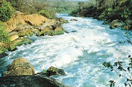
The Ruo River is the largest tributary of the Shire River in southern Malawi and Mozambique. It originates on the slopes of the Mulanje Mountains and flows…
What is Ruo River?
The Ruo River is the largest tributary of the Shire River in southern Malawi and Mozambique. It originates on the slopes of the Mulanje Mountains and flows south toward Mulanje town before turning southwest.1
For approximately 80 miles (130 km), the river serves as the border between Malawi and Mozambique, eventually joining the Shire River at the village of Chiromo. The Ruo’s catchment area covers roughly 1,900 square miles (4,900 square km), draining the southern portion of the eastern Shire Highlands. Due to its periodic heavy discharge, the river is known to cause severe flooding in the region. Historically, the volume of the Ruo River has been a significant factor in the flow of the lower Shire River.12
What are the Mulanje Mountains like?
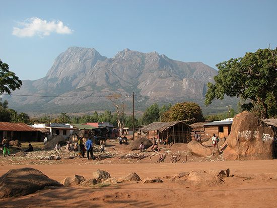
The Mulanje Mountains are a striking geological feature in southeastern Malawi, rising abruptly from the surrounding plateau as a massive, nearly rectangular syenite formation.4
Geography and Climate
The massif reaches its highest point at Mulanje Peak (9,848 ft/3,002 m), which is the tallest peak in Malawi. The landscape is defined by distinct erosional features, including deep, narrow clefts, crater-like hollows, and high plateaus. The climate on the upper levels is significantly cooler than the surrounding plains, with frost occurring during the month of July. The area also experiences high precipitation, with the Sapitwa peak receiving approximately 90 inches (2,300 mm) of rain annually.45
Ecology and Economy
The mountains are home to the Mulanje cedar, which grows on steep slopes and in ravines, reaching heights of over 100 feet. These forests are a vital component of the local forestry industry. Additionally, the region supports tea plantations on its southern slopes and contains bauxite deposits on its plateaus. Numerous streams drain the massif, feeding into the Ruo River and Lake Chilwa.41
How do rivers influence international borders?
Rivers often serve as natural boundaries between nations, but their dynamic nature and the essential need for shared water resources frequently necessitate formal legal frameworks to maintain stability.
Geopolitical and Legal Challenges
When a river acts as an international border, it can create complex geopolitical tensions, particularly when upstream and downstream nations have competing needs for irrigation, hydroelectric power, or flood control. Because rivers are fluid systems, changes in water flow or infrastructure projects—such as the construction of dams—can significantly impact the rights and economic stability of neighboring states.6
The Role of Treaties
To manage these shared interests, nations often establish formal agreements to delimit water rights. A prominent example is the Indus Waters Treaty, signed in 1960 between India and Pakistan. This agreement successfully divided the Indus River system, allocating specific rivers to each country to ensure equitable usage. Such treaties often include:
- Resource Allocation: Defining which nation controls the flow of specific tributaries.6
- Dispute Resolution: Establishing commissions or arbitration courts to settle technical and legal disagreements.6
- Infrastructure Oversight: Setting limits on water-control projects to prevent one nation from unilaterally restricting the water supply of another.6
What is the role of the Shire River in Malawi?
The Shire River is the most important river in Malawi, serving as the sole outlet for Lake Nyasa and playing a critical role in the nation’s economy and infrastructure.2
Energy and Irrigation
The river is a vital source of electric power for the country. Hydroelectric schemes located at Nkula, Tedzani, and Kapichira Falls harness the river’s flow to supply energy to industrial areas, particularly near Blantyre.2 Additionally, the river’s middle course holds significant potential for irrigation, supporting large-scale agricultural operations such as sugar estates.8
Hydrology and Regulation
The Shire’s flow is historically dependent on the levels of Lake Nyasa and the Ruo River. To manage these resources, a dam at Liwonde regulates water flow for hydroelectric generation and provides flood control for the lower reaches. The river also flows through Lake Malombe, where its marshy shores support seasonal agriculture and commercial fishing. However, environmental challenges, such as deforestation near river sources, have occasionally reduced water flow, impacting the reliability of the country’s power supply.298
Sources
- Ruo River — Encyclopædia Britannica
- Shire River — Encyclopædia Britannica
- Mozambique - Drainage of Mozambique — Encyclopædia Britannica
- Mulanje Mountains — Encyclopædia Britannica
- Malawi - Climate — Encyclopædia Britannica
- river - Morphology of deltas — Encyclopædia Britannica
- Indus Waters Treaty — Encyclopædia Britannica
- Malawi - Resources and power — Encyclopædia Britannica
- Lake Malombe — Encyclopædia Britannica
Published on · 3 min read