Negros
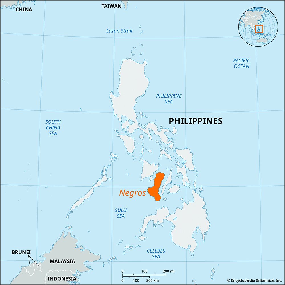
Negros is a boot-shaped island located within the Visayan Islands of the central Philippines. It is bounded by the Guimaras Strait to the northwest, the…
Where is Negros Island located within the Philippines, and what are its major geographical features?
Negros is a boot-shaped island located within the Visayan Islands of the central Philippines. It is bounded by the Guimaras Strait to the northwest, the Tanon Strait to the east, and the Visayan and Sulu seas to the north and south, respectively.1
The island’s geography is defined by a lofty, eroded central mountain range that spans nearly its entire length. This range includes Mount Canlaon, an active volcano and the island’s highest point at 8,086 feet. While the eastern coast features discontinuous piedmont plains, the western coast contains some of the broadest lowlands in the Philippines. Other notable features include the Binalbagan, Ilog, Tolong, and Tanjay rivers, as well as the crater lakes of Danao and Balinsasayan located on the southeastern peninsula. Additionally, the southwest contains the Tablas, an undeveloped plateau with a varied landscape.1
What are the main languages spoken on Negros Island, and how do they reflect its cultural diversity?
The linguistic landscape of Negros Island is primarily defined by a division between its eastern and western coasts, a separation reinforced by the island’s lofty central mountain range.3
- Hiligaynon: This language, originating from the neighboring island of Panay, is the dominant tongue in western Negros. The Hiligaynon people are one of the largest ethnolinguistic groups in the Philippines, and their presence in the west reflects strong historical and economic ties to Panay, particularly through the sugarcane industry.314
- Cebuano: This language is dominant on the eastern coast of Negros. Cebuano speakers, who are also widespread across Cebu and Bohol, reflect the island’s cultural connection to the eastern Visayan Islands.351
This linguistic split highlights the island’s diverse cultural heritage, as the mountain range historically limited interaction between the two coasts. Furthermore, while Visayans inhabit the coastal plains, the forested upland interior is home to Negritos, representing the island’s indigenous cultural diversity.3
What are some of the notable tourist attractions and natural wonders on Negros Island?
Negros Island offers a variety of natural wonders and urban attractions for visitors.
Natural Wonders
- Mount Canlaon: As the highest point in the Visayan Islands, this active volcano reaches 8,086 feet (2,465 meters). The surrounding Mount Canlaon National Park covers 95 square miles of rugged, forested terrain featuring hot springs, craters, and diverse wildlife, including monkeys, deer, and boars.167
- Crater Lakes: The southeastern peninsula of the island is home to the scenic crater lakes of Danao and Balinsasayan.1
- The Tablas Plateau: Located in the southwest, this undeveloped plateau offers a unique, varied landscape for those interested in exploring the island’s interior.1
Urban Attractions
- Bacolod: Known as the “Philippine sugar capital,” the island’s largest city features a distinct rectangular street pattern. Visitors can explore the provincial capitol building, which is set within spacious, landscaped grounds, as well as the historic stone church and convent located in the central square.8
- Canlaon City: Situated on the eastern slopes of the volcano, this city serves as a gateway to the national park and is connected by road to the island’s coastal highways.7
How is Negros Island divided administratively, and what are its major cities?
Negros Island is geographically and culturally divided by a lofty central mountain range that runs nearly the entire length of the island, separating the eastern and western coastal areas. While the provided information details the island’s geography and major urban centers, it does not specify the current administrative divisions (such as the provinces of Negros Occidental and Negros Oriental).1
The island’s major cities are distributed along its coastal regions and include:
- Bacolod: Located on the northwestern coast, it is the largest city on the island and serves as a vital regional trade center and sugar exporter.12
- Bago: Situated in the western portion of the island, this city is a significant center for sugar milling and rice production.18
- Other notable cities: The island also features Bais, Cadiz, Escalante, La Carlota, Dumaguete, and Canlaon.1
A coastal highway system links these cities and towns, facilitating trade and transportation across the island’s diverse landscape.1
Sources
- Negros — Encyclopædia Britannica
- Bago — Encyclopædia Britannica
- Hiligaynon — Encyclopædia Britannica
- Philippines - Languages — Encyclopædia Britannica
- Visayan Islands — Encyclopædia Britannica
- Mount Canlaon — Encyclopædia Britannica
- Canlaon — Encyclopædia Britannica
- Bacolod — Encyclopædia Britannica
Published on · 3 min read