North Sea
The North Sea is a vital economic hub for Europe, characterized by three primary activities:
What are the major economic activities associated with the North Sea?
The North Sea is a vital economic hub for Europe, characterized by three primary activities:
- Oil and Natural Gas Production: Since the late 1950s, the North Sea has become western Europe’s most significant petroleum and natural gas production region. Norway and the United Kingdom are the leading producers, utilizing extensive offshore infrastructure and pipelines to transport energy resources to the mainland.123
- Shipping and Trade: The sea serves as one of the world’s busiest shipping zones, facilitating transit between European nations and global markets. It hosts some of the world’s largest ports, including Rotterdam, Antwerp, and Hamburg.14
- Fisheries: The North Sea has historically been one of Europe’s most productive fishing grounds, remaining a key industry despite the challenges of sharing space with industrial shipping and energy platforms.14
These activities have necessitated international cooperation, such as the OSPAR Convention, to address the significant environmental impacts of pollution and industrial waste.5
How has the North Sea influenced the development of fishing industries in surrounding countries?
The North Sea has been a cornerstone of the fishing industries for bordering nations—primarily Norway, Denmark, the United Kingdom, and the Netherlands—due to its shallow basin, which provides a rich supply of nutrients that support diverse marine life.78
The development of these industries has been shaped by several key factors:
- Technological Innovation: Advances in fishing methods, such as the development of automated longline systems in Norway, have revolutionized efficiency, allowing smaller crews to manage larger operations.9
- Scientific Management: The region has a long history of marine research, notably through the International Council for the Exploration of the Sea (ICES), which has provided the world’s longest record of marine ecological conditions to advise governments on resource sustainability.10
- Regulatory Frameworks: To manage shared resources, European nations adopted the Common Fisheries Policy in 1983. This system establishes annual catch quotas and allocates them among member states, effectively treating the sea as a single “pond” to ensure both economic and ecological sustainability.7
While the North Sea remains highly productive, it faces ongoing challenges from industrial competition and the need for stringent monitoring to prevent the type of catastrophic stock collapses seen in other regions.76
What are some of the most significant oil and gas fields in the North Sea?
The North Sea is a critical region for energy production, hosting several major oil and gas fields that have shaped the economies of surrounding nations. Some of the most significant include:
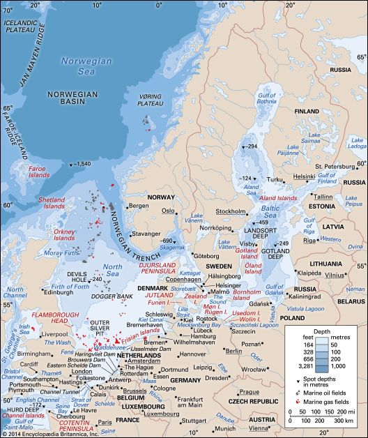
- Ekofisk: Located in the Norwegian sector, this group of fields was the first supergiant discovery in the North Sea (1969). It remains a major producer and is currently undergoing expansion projects, such as Ekofisk South and Eldfisk II, to increase reserve recovery.114
- Forties: Identified in 1970, this supergiant field was the second major commercial discovery in the North Sea and stands as a landmark in the United Kingdom’s offshore production history.4
- Johan Sverdrup: Discovered in 2010, this is one of the most recent giant field discoveries in the region. It holds estimated total reserves of 1.7 to 3.3 billion barrels, highlighting the ongoing potential for resource development in the area.4
- Cod, Tor, West Ekofisk, and Albuskjell: These fields are part of the broader Ekofisk district, contributing significantly to the region’s total petroleum and natural gas output since the early 1970s.11
What are the geographical boundaries and dimensions of the North Sea?
The North Sea is a shallow, northeastern arm of the Atlantic Ocean covering an area of approximately 220,000 square miles (570,000 square km).1
Geographical Boundaries
The sea is bounded by several nations and landmasses:
- Southwest and West: The island of Great Britain.1
- Northwest: The Orkney and Shetland islands.1
- Northeast: Norway.1
- East: Denmark.1
- Southeast: Germany and the Netherlands.1
- South: Belgium and France.1
It connects to the Atlantic via the Strait of Dover and the English Channel, and it links to the Baltic Sea through the Skagerrak and Kattegat.1
Dimensions and Depth
The basin is notably shallow, with most areas measuring less than 300 feet (90 meters) in depth. While the southern floor is generally less than 120 feet (35 meters) deep, the Norway Deep—a trench running parallel to the Norwegian coast—reaches depths of approximately 2,300 feet (700 meters).12
Sources
- North Sea — Encyclopædia Britannica
- North Sea - Oil and gas — Encyclopædia Britannica
- North Sea - Trade and transportation — Encyclopædia Britannica
- petroleum - North Sea — Encyclopædia Britannica
- Nova Scotia - Economy — Encyclopædia Britannica
- North Sea - The impact of human activity — Encyclopædia Britannica
- North Sea - Fisheries — Encyclopædia Britannica
- cod fishery collapse of 1992 — Encyclopædia Britannica
- North Sea - Study and exploration — Encyclopædia Britannica
- commercial fishing - Bottom longlines — Encyclopædia Britannica
- Ekofisk — Encyclopædia Britannica
- North Sea - Hydrology — Encyclopædia Britannica
- Norway Deep — Encyclopædia Britannica
- North Sea - Physiography — Encyclopædia Britannica
Published on · 4 min read