Pediplain
A pediplain is a broad, relatively flat rock surface created by the merging of several pediments. These landforms typically develop in arid or semi-arid…
What is pediplain?
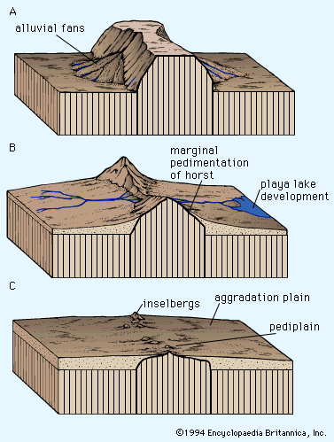
A pediplain is a broad, relatively flat rock surface created by the merging of several pediments. These landforms typically develop in arid or semi-arid climates and may be covered by a thin layer of sediment.12
Geomorphologically, a pediplain is categorized as a type of planation surface—a low-relief landscape that cuts across varied rock structures. While some researchers, such as Lester C. King, have argued that the process of pedimentation is responsible for many of the world’s ancient planation surfaces, most modern geomorphologists view it as a localized process occurring primarily at mountain fronts. It is often theorized that the pediplain represents the final stage of landform evolution resulting from long-term erosional processes.21
What is the difference between a pediment and a pediplain?
The primary difference between a pediment and a pediplain lies in their scale and formation:
- Pediment: A pediment is a relatively flat, erosional bedrock surface found at the base of a mountain or hill. It typically features a slight concave slope (ranging from 0.5° to 7°) and is often characterized by a sharp break where it meets the steeper hillside above. While they can occur in various climates, they are most conspicuous in arid regions where intense, brief rainfall facilitates sheet flow across the surface.31
- Pediplain: A pediplain is a broad, extensive landscape formed by the coalescence (joining) of multiple pediments. While a pediment is often associated with an individual mountain front, a pediplain represents a larger, regional surface. Some geomorphologists theorize that the formation of a pediplain—a process known as pedimentation—may represent the final stage of landform evolution resulting from long-term erosion.241
Both features are classified as planation surfaces, which are low-relief plains that cut across varied rock structures.1
How does the process of etchplanation differ from pediplanation?
The processes of etchplanation and pediplanation differ primarily in their reliance on weathering versus mechanical erosion to create a planation surface.
- Etchplanation: This process is driven by deep weathering. Over time, a thick layer of weak, weathered rock (regolith) forms over intact bedrock. A new surface is created when subsequent erosion removes this weathered material, effectively “etching” the underlying, more resistant rock compartments into a flat landscape. This process has been particularly characteristic of stable, ancient cratonic areas, such as those found in Gondwanaland.2
- Pediplanation: This process is characterized by the lateral erosion and retreat of mountain fronts. It involves the coalescence of multiple pediments—erosional bedrock surfaces at the base of slopes—into a broad, regional plain known as a pediplain. Pediplanation is most commonly associated with arid or semi-arid climates where mechanical processes, such as sheet flow, dominate the landscape’s evolution.25
While both result in low-relief plains that cut across varied rock structures, etchplanation is defined by the exposure of a subsurface weathering front, whereas pediplanation is defined by the progressive expansion and joining of erosional surfaces at mountain fronts.2
What are some examples of famous planation surfaces on Earth?
A planation surface is a low-relief landscape that cuts across varied rock structures, often resulting from long-term erosional processes. While these surfaces are common in tectonically stable regions, identifying specific, universally accepted examples can be complex due to ongoing scientific debate regarding their origins.
Notable examples and features include:
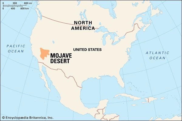
- Cima Dome: Located in the eastern Mojave Desert of California, this is considered an excellent example of an advanced stage of planation. It features a dome-like surface formed by the coalescence of pediments as the surrounding mountain mass retreated.2
- James Range: In central Australia, this region displays a spectacular planation surface that bevels sandstone cuestas. The alignment of these beveled features at approximately the same elevation provides clear evidence of a regional erosive process that once acted at a specific base level.2
- Gondwana Surfaces: Geomorphologist Lester C. King identified ancient, Mesozoic-age surfaces across the Southern Hemisphere, which he termed the Gondwana sequence. These are associated with the ancient supercontinent Pangaea and its subsequent breakup.2
- African or Moorland Surface: A younger planation surface that developed during the Late Cretaceous and Early Cenozoic, primarily through the stripping of weathered materials from older, underlying surfaces.2
Sources
- pediplain — Encyclopædia Britannica
- planation surface — Encyclopædia Britannica
- pediment — Encyclopædia Britannica
- pediplain — Merriam-Webster
- pediplanation — Merriam-Webster
- weathering — Encyclopædia Britannica
- etching — Merriam-Webster
- evolution of the atmosphere - Weathering reactions — Encyclopædia Britannica
- Quaternary - Landforms — Encyclopædia Britannica
- peneplain — Encyclopædia Britannica
Published on · 3 min read