Peneplain
A peneplain is defined as a gently undulating, nearly featureless plain that, in theory, results from long-term fluvial erosion reducing a landscape to…
What is the definition of a peneplain in geological terms?
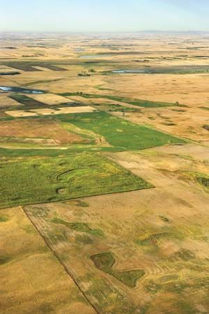
A peneplain is defined as a gently undulating, nearly featureless plain that, in theory, results from long-term fluvial erosion reducing a landscape to baselevel, or sea level. The term, which literally means “almost a plain,” was introduced in 1889 by William M. Davis as the final stage of his geomorphic cycle of landform evolution.12
The concept remains a subject of scientific debate. Critics argue that the Earth’s crust is rarely stable long enough for such extensive erosion to occur, and the lack of modern-day examples has led many geomorphologists to favor the more descriptive term planation surface for low-relief landscapes. Proponents of the theory often point to accordant summits, uniform truncation of rock strata, and residual soil mantles as evidence of ancient, uplifted peneplains. Because the term is so closely tied to the specific Davisian theory of landscape development, it is used less frequently in modern geomorphology.12
How are peneplains formed over time?
According to the theory proposed by William M. Davis, peneplains are formed through a long-term geomorphic cycle of landform evolution. This process involves the following stages and mechanisms:13
- Initiation: The cycle typically begins with the uplift of a landmass above sea level, which provides the potential energy necessary for erosive processes to begin.34
- Fluvial Erosion: Over vast stretches of geologic time, the combined action of running water and gravity wears down the landscape. Rivers incise the terrain, and hillslope processes reduce the overall relief.1435
- Progression: Davis categorized this evolution into stages—youth, maturity, and old age—during which the landscape is progressively leveled. As the land surface approaches baselevel, the gradient decreases, significantly slowing the rate of erosion.3514
- Final Stage: The process theoretically culminates in a “peneplain” (meaning “almost a plain”), a gently undulating, featureless surface of extremely low relief. In this state, the land is so close to baselevel that further erosion is minimal. Occasionally, erosionally resistant highs known as monadnocks may remain on the surface.154
While this model was influential, modern geomorphology often questions the assumption that the Earth’s crust remains stable long enough for such extensive erosion to occur, and many researchers now prefer the more descriptive term planation surface.15
How do peneplains contribute to our understanding of long-term landscape evolution?
The concept of the peneplain, introduced by William M. Davis in 1889, has historically served as a foundational, albeit debated, model for understanding long-term landscape evolution. By proposing that landscapes progress through a geomorphic cycle—moving from youth and maturity to an “old age” characterized by a nearly featureless plain—Davis provided a framework for interpreting how fluvial erosion acts over vast geologic time to reduce terrain toward baselevel.11
Peneplains contribute to our understanding of Earth’s history by offering criteria to identify ancient, uplifted surfaces. Proponents look for evidence such as accordant summits, the uniform truncation of rock strata, and residual soil mantles to reconstruct past erosional environments. However, the theory has also shaped modern geomorphology by highlighting the complexities of crustal stability. The frequent absence of true peneplains has led many scientists to question whether the Earth’s crust remains stable long enough for such extensive leveling to occur.21
Today, while the term “peneplain” is used less frequently due to its specific genetic ties to Davisian theory, it remains a vital reference point. Geomorphologists now often prefer descriptive terms like planation surface to analyze low-relief landscapes, acknowledging that these features are essential for interpreting tectonic and climatic changes over millions of years.21
How has our understanding of peneplains evolved with advancements in geological sciences?
Our understanding of peneplains has shifted significantly as geological sciences have moved away from the rigid, time-dependent models of the past toward more dynamic, process-oriented interpretations.
The Davisian Era
In 1889, William M. Davis introduced the concept of the peneplain as the final, “old-age” stage of his geomorphic cycle. Davis theorized that landscapes evolved predictably through stages of youth, maturity, and old age, with fluvial erosion eventually reducing terrain to a near-featureless plain at baselevel. This model prioritized time as the primary factor in landform development.17
Modern Scientific Critique
Advancements in quantitative data and geological theory have largely discredited the strict Davisian cycle. Modern geomorphology highlights several flaws in the original theory:7
- Crustal Instability: Evidence suggests the Earth’s crust rarely remains stable long enough for such extensive, uniform erosion to occur.1
- Climatic Complexity: Davis assumed a “normal” humid climate, ignoring the profound impact of climatic variability and climatic geomorphology on landscape evolution.23
- Dynamic Equilibrium: Current research emphasizes that landforms often reach a state of dynamic equilibrium with environmental processes rather than following a predetermined, sequential path toward a final “end” state.7
Contemporary Perspectives
Because the term “peneplain” is genetically tied to the now-outdated Davisian theory, it is rarely used in modern scientific literature. Instead, researchers prefer the descriptive term planation surface to categorize low-relief plains. Scientists now recognize that these surfaces are often “palimpsests”—landscapes that reflect a complex history of weathering, tectonic movement, and changing climates over millions of years, rather than a single, simple erosional cycle.1112
Sources
- peneplain — Encyclopædia Britannica
- planation surface — Encyclopædia Britannica
- geomorphic cycle — Encyclopædia Britannica
- continental landform - Davisian dynamic equilibrium — Encyclopædia Britannica
- baselevel — Encyclopædia Britannica
- continental landform - The geomorphic concepts of Penck and King — Encyclopædia Britannica
- continental landform - The geographic cycle — Encyclopædia Britannica
- pediplain — Encyclopædia Britannica
- valley - Geomorphic characteristics — Encyclopædia Britannica
- monadnock — Encyclopædia Britannica
- valley - Role of climatic change — Encyclopædia Britannica
- valley - Influence of climate — Encyclopædia Britannica
- dating - Uranium-series disequilibrium dating — Encyclopædia Britannica
Published on · 4 min read