Planation Surface
A planation surface is a broad, low-relief landscape feature that cuts across varied rock types and geological structures. These surfaces are among the most…
What is a planation surface in geology, and how does it form?
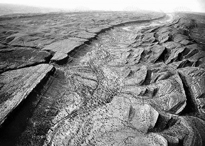
A planation surface is a broad, low-relief landscape feature that cuts across varied rock types and geological structures. These surfaces are among the most common landforms on Earth and are typically defined by their flatness, which indicates that a lateral erosive process occurred at a specific base level in the past.1
Formation Processes
Planation surfaces form through various erosive mechanisms, often depending on the local climate and tectonic stability:
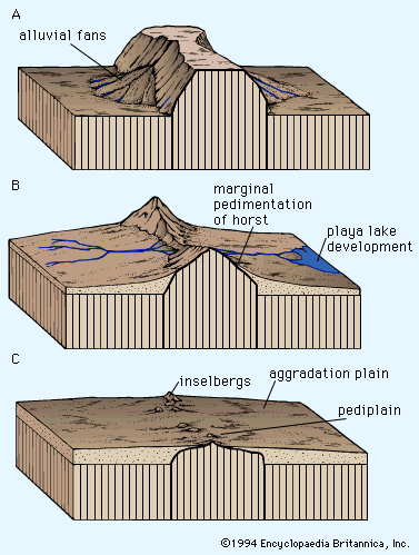
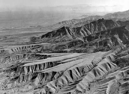
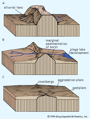
- Pedimentation: This involves the retreat of mountain fronts through the backwearing of slopes and the removal of weathered material by fluvial and slope processes. When these individual pediments coalesce over a broad region, they form a pediplain.12
- Etchplanation: In this process, deep weathering creates a thick layer of decomposed rock (regolith) over intact bedrock. Subsequent erosion removes the weathered material, “etching” a new, flat surface into the underlying resistant rock.1
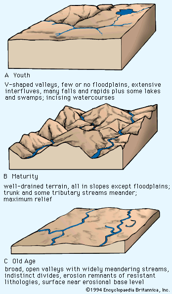
- Cyclic Erosion: Older theories, such as those proposed by W.M. Davis, suggested that rivers and hillslopes gradually reduce the landscape to a plain of extremely low relief, historically termed a peneplain.1
Because these surfaces often represent complex erosional histories, modern geomorphology prefers the descriptive term “planation surface” over names that imply a specific genetic origin.1
What is the significance of peneplains in the study of planation surfaces?
In the study of planation surfaces, the concept of a peneplain is historically significant but controversial. Introduced by William M. Davis in 1889, the term describes a gently undulating, nearly featureless plain that represents the final “old age” stage of his geomorphic cycle of landform evolution8.81
The significance of the peneplain in geological literature lies in its role as a theoretical framework for interpreting landscapes. Proponents historically used it to explain:
- Accordant summits: Remnants of an uplifted, dissected plain.9
- Truncation: The uniform cutting across rock strata of varying resistance.9
- Residual soil: The presence of weathered mantles on flat surfaces.9
However, the concept is rarely used in modern geomorphology because it is tied to the rigid Davisian theory, which assumes that time is the primary factor in landform development—a view largely superseded by the concept of dynamic equilibrium. Because the term carries specific genetic implications that are often debated, modern scientists prefer descriptive, neutral terms like “planation surface” or “erosion surface” to categorize these features without assuming a predetermined evolutionary history.819
How do geologists use planation surfaces to understand past geological processes?
Geologists use planation surfaces as vital indicators to reconstruct the Earth’s long-term landscape evolution and tectonic history. Because these low-relief plains require specific conditions to form—typically a stable base level and prolonged lateral erosion—their presence and elevation provide a record of past geological processes.1
Key ways geologists utilize these surfaces include:
- Identifying Tectonic Stability and Uplift: When planation surfaces are found at high elevations, they serve as “relict” features. Their current position relative to their original base level allows geologists to calculate the amount and timing of regional tectonic uplift.1
- Correlating Global Phases: By mapping these surfaces, researchers can identify phases of cyclic planation. For example, ancient surfaces like those associated with Gondwana help geologists correlate landscape development across continents, providing evidence for the breakup of supercontinents during the Mesozoic.1
- Interpreting Paleoclimates: The processes that form these surfaces, such as etchplanation, often require specific climatic conditions like deep tropical weathering. The remnants of these surfaces, along with associated regolith, allow scientists to infer the climatic regimes that existed millions of years ago.111
- Dating Landscape History: Younger surfaces found at lower elevations relative to older, higher remnants indicate incomplete planation phases, helping geologists sequence the erosional history of a region over the Neogene and Pleistocene periods.1
How do planation surfaces relate to the concept of geomorphic cycles?
In the study of geomorphology, the relationship between planation surfaces and geomorphic cycles is rooted in the historical effort to explain how landscapes evolve over time.98
The Davisian Framework
The concept of the geomorphic cycle, developed by William M. Davis, proposed that landforms progress through a predictable sequence of “youth,” “maturity,” and “old age.” In this model, a peneplain represents the final, “old age” stage, where prolonged fluvial erosion reduces the land to a nearly featureless plain at sea level. Within this cycle, planation surfaces are viewed as the end product of a long-term, time-dependent process of landscape degradation.918
Theoretical Evolution and Controversy
The relationship between these concepts has faced significant scientific scrutiny:
- Cyclical vs. Dynamic Equilibrium: Modern geomorphology has largely moved away from the Davisian cycle, favoring the concept of dynamic equilibrium. This view suggests that landforms do not necessarily follow a predetermined evolutionary path toward a specific end state, but rather adjust to the processes acting upon them.95
- Alternative Models: Other theorists, such as Walther Penck and Lester C. King, adapted the idea of cyclic planation by emphasizing lateral escarpment retreat rather than the simple wearing down of land. King, for instance, proposed that pediplains were formed through pedimentation, a process he believed could be correlated globally.813
- Terminology: Because the term “peneplain” is genetically tied to the now-debated Davisian theory, modern geologists prefer the neutral term “planation surface” to describe low-relief plains without assuming a specific, predetermined history.98
Sources
- planation surface — Encyclopædia Britannica
- pediplain — Encyclopædia Britannica
- erosion surface — Merriam-Webster
- continental landform — Encyclopædia Britannica
- continental landform - Behaviour of geomorphic systems — Encyclopædia Britannica
- planing surface — Merriam-Webster
- planer — Encyclopædia Britannica
- peneplain — Encyclopædia Britannica
- geomorphic cycle — Encyclopædia Britannica
- peneplain — Merriam-Webster
- river - River terraces — Encyclopædia Britannica
- valley - Role of climatic change — Encyclopædia Britannica
- continental landform - The geomorphic concepts of Penck and King — Encyclopædia Britannica
Published on · 4 min read