Permafrost
Permafrost is defined in geological terms as ground that remains at a temperature of 0 °C (32 °F) or colder continuously for two or more years. This…
What is permafrost, and how is it defined in geological terms?
Permafrost is defined in geological terms as ground that remains at a temperature of 0 °C (32 °F) or colder continuously for two or more years. This classification is based exclusively on temperature rather than the presence of ice; while most permafrost is consolidated by frozen water, “dry permafrost” can exist in areas where the soil contains no moisture.1
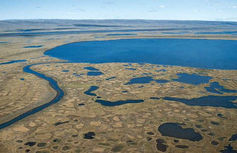
The upper boundary of this frozen layer is known as the permafrost table, while the surface layer that thaws during the summer is called the active layer. Permafrost forms in climates where the mean annual air temperature is 0 °C or colder, allowing ground frozen during the winter to remain frozen throughout the year. Over time, this layer can grow to significant depths, reaching an equilibrium controlled by the geothermal gradient and the thermal balance between Earth’s interior heat and the atmosphere.12
How does the presence of permafrost influence construction and infrastructure development in affected areas?
The presence of permafrost presents significant challenges for engineering and infrastructure, primarily due to the ground’s delicate thermal equilibrium. Construction in these regions generally follows two strategies: the “passive method,” which aims to preserve the permafrost, or the “active method,” which involves destroying it if it is thin enough to allow for a stable foundation.5
Key challenges include:
- Thawing and Subsidence: Heat from buildings, roads, or pipelines can melt ice-rich permafrost, leading to loss of bearing strength and surface subsidence. This can create thermokarst features, such as pits and sinkholes.567
- Frost Heaving: The freezing and thawing of ground moisture causes upward displacement of the soil, which can severely damage or destroy foundations, bridges, and pipelines.86
- Infrastructure Maintenance: Roads and railroads often require constant, costly upkeep to level tracks and surfaces displaced by seasonal freezing and thawing.9
- Mitigation Techniques: Engineers often use thick gravel pads to restrict temperature fluctuations to the fill layer. For structures like the Trans-Alaska Pipeline, engineers elevated the line and used thermal devices to prevent heat from thawing the underlying ground.68
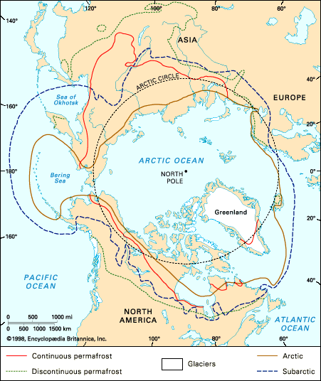
How does permafrost form, and in which regions of the world is it most commonly found?
Permafrost forms in climates where the mean annual air temperature is 0 °C (32 °F) or colder. In these environments, ground that freezes during the winter does not completely thaw during the summer. Over time, this layer grows downward, with its thickness determined by the thermal balance between the geothermal gradient (heat from Earth’s interior) and the cooling effect of the atmosphere. Reaching an equilibrium depth where these heat flows balance can take thousands of years.13
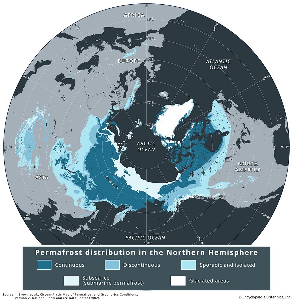
Permafrost is widespread in the Arctic, subarctic, and Antarctica, underlying approximately 24 percent of the land surface in the Northern Hemisphere. Key regions include:1
- Northern Hemisphere: It covers roughly 85 percent of Alaska and 55 percent of Russia and Canada.10
- Alpine Regions: Permafrost also exists at lower latitudes in high-elevation areas, such as the mountains of western China and the western United States.10
- Offshore: Subsea permafrost is found on the northern continental shelves of North America and Eurasia.10
What methods do scientists use to study and monitor permafrost?
Scientists employ a variety of techniques to study and monitor permafrost, focusing on its thermal state, physical composition, and distribution. Key methods include:
- Temperature Measurements: Researchers measure ground temperatures at various depths to understand the thermal profile of the soil. Historically, this has involved using boreholes, such as the early measurements taken in the Shargin shaft in Yakutsk, to determine thickness and temperature gradients.2
- Geophysical Methods: These techniques are essential for identifying the presence and movement of perennial ice, particularly in alpine regions. Geophysical surveys allow scientists to detect subsurface features like rock glaciers without invasive excavation.2
- Borehole Examination: Direct examination of boreholes provides critical data on the type, water content, and ice content of the ground. This is especially vital for subsea permafrost research, which informs the planning of offshore infrastructure and the identification of gas hydrates.112
- Predictive Modeling: By analyzing the geothermal gradient and mean annual air temperatures, scientists can predict permafrost thickness and stability in areas where direct measurement is difficult.12
We could dive deeper into how these monitoring techniques help track the impacts of climate change on permafrost stability.
Sources
- permafrost — Encyclopædia Britannica
- permafrost - Air temperature and ground temperature — Encyclopædia Britannica
- permafrost - Permafrost zones — Encyclopædia Britannica
- Tundra - Soils — Encyclopædia Britannica
- permafrost - Structures on piles — Encyclopædia Britannica
- permafrost - General issues — Encyclopædia Britannica
- permafrost - Permafrost thawing and frost heaving — Encyclopædia Britannica
- thermokarst — Encyclopædia Britannica
- permafrost - Highways and railroads — Encyclopædia Britannica
- permafrost - Climatic change — Encyclopædia Britannica
- permafrost - Offshore structures — Encyclopædia Britannica
- permafrost - Study of permafrost — Encyclopædia Britannica
Published on · 4 min read