Felsenmeer
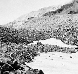
A felsenmeer (German for "sea of rock") is an expansive surface area covered by a mantle of angular, frost-shattered rock fragments. These features typically…
What is felsenmeer?
A felsenmeer (German for “sea of rock”) is an expansive surface area covered by a mantle of angular, frost-shattered rock fragments. These features typically form in Arctic regions and high mountain areas above the timberline, where repeated cycles of freezing and thawing cause bedrock to break apart.123
Because the tensional strength of rock is often exceeded by the pressure of water crystallizing within its cracks, exposed outcrops are effectively reduced to rubble. These deposits can reach depths of up to 4 meters (12 feet) and are particularly well-developed on basaltic and sedimentary rocks. While felsenmeers are often found on relatively flat surfaces that can retain loose debris, the fragments may also be transported downslope by water or frost-induced creep. In some instances, these accumulations are associated with other periglacial features, such as talus slopes or rock glaciers.213
What is the difference between a felsenmeer and a talus slope?
While both felsenmeers and talus slopes consist of angular, frost-shattered rock fragments, they are distinguished primarily by their location and the processes that shape them.
- Felsenmeer: This term refers to an expansive, blanket-like area of debris that covers relatively flat or gently sloping surfaces, such as high mountain peaks or plateaus. These features form in situ as repeated freeze-thaw cycles shatter exposed bedrock into rubble.2
- Talus: In contrast, talus consists of accumulations of angular debris found specifically at the base of steep slopes or cliffs. This material is often transported downslope from higher elevations through rockfalls or gravity-driven processes. When debris is channeled through specific chutes, it forms distinct talus cones, which can eventually coalesce into a continuous talus apron along the base of a valley wall.2
Essentially, a felsenmeer represents a broad “sea” of debris covering a surface, whereas talus represents a concentrated pile of debris deposited at the foot of a steep incline.2
How do rock glaciers form from mountain debris?
Rock glaciers form in high mountain regions where thick accumulations of talus—angular rock debris—remain at sub-freezing temperatures throughout the year. The process typically involves the following stages:
- Ice Accumulation: Rain or meltwater percolates into the spaces between the rock fragments. Over time, this water freezes, filling the pore spaces with interstitial ice.4
- Mass Movement: In some instances, enough ice accumulates to enable the entire mass of rock and ice to move downslope under the influence of gravity, behaving similarly to a glacier influence of gravity, behaving similarly to a glacier.2
- Flow Characteristics: The movement of a rock glacier is thought to occur through the flowage of the internal ice or by creeping caused by frost action. These features often exhibit wavelike surface ridges that curve downstream, indicating active flow.2
While some rock glaciers contain significant amounts of interstitial ice, others may consist of pure ice buried beneath a thick layer of talus, potentially representing the final retreat stages of former valley glaciers.4
What other landforms are created by frost weathering?
Beyond felsenmeers, talus slopes, and rock glaciers, frost weathering and related periglacial processes create several distinct landforms:
- Pingos: These are dome-shaped hills found in permafrost regions. They form when the pressure of freezing groundwater pushes up a layer of frozen ground, creating a core of clear ice. If the top ruptures, it may expose the ice to melting, resulting in a small crater or lake.2
- Patterned Ground: Intense, repetitive freeze-thaw cycles stir and sort granular sediments, creating small-scale features such as stone nets, circles, and polygons. In these features, coarse cobbles and boulders typically form the outer ring, while finer sediments occupy the center.7
- Stone Stripes: On steeper slopes, the sorting process associated with patterned ground is distorted by downslope movement, stretching the features into roughly parallel bands of alternating coarse and fine rock debris known as stone stripes.78
These features are primarily driven by the expansion of water as it freezes, which exerts immense pressure capable of fracturing rock and heaving soil.9
Sources
- felsenmeer — Encyclopædia Britannica
- glacial landform - Felsenmeers, talus, and rock glaciers — Encyclopædia Britannica
- felsenmeer — Merriam-Webster
- rock glacier — Encyclopædia Britannica
- glacial landform - Glacial erosion — Encyclopædia Britannica
- glacial landform - Glacial deposition — Encyclopædia Britannica
- pingo — Encyclopædia Britannica
- permafrost - Patterned ground — Encyclopædia Britannica
- stone stripe — Merriam-Webster
- glacial landform - Periglacial landforms — Encyclopædia Britannica
Published on · 3 min read