Playa
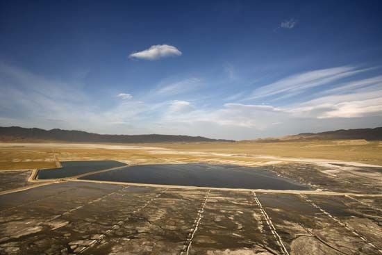
A playa is a flat-bottomed depression located in interior desert basins or near coasts in arid and semiarid regions. These landforms are among the flattest…
What is a playa in geological terms, and how does it form?
A playa is a flat-bottomed depression located in interior desert basins or near coasts in arid and semiarid regions. These landforms are among the flattest on Earth, often characterized by slopes of less than 0.2 meters per kilometer.1
Formation
Playas form in enclosed basins where drainage is internal and evaporation rates significantly exceed water inflow. They are created through several geological processes:1
- Tectonic Activity: Faulting and warping can create the depressions necessary for basin formation.2
- Wind Deflation: Wind can erode surface material to create shallow basins.2
- Cataclysmic Events: Volcanism, landslides, or meteorite impacts can disrupt drainage patterns, leading to the creation of a basin.2
- Desiccation: Many playas originate from the drying up of former lakes, leaving behind lacustrine sediments.2
When these basins flood, they form a temporary playa lake. As the water evaporates or infiltrates the ground, it leaves behind deposits of salt, sand, and mud, which maintain the surface’s characteristic flatness through repeated cycles of inundation.134
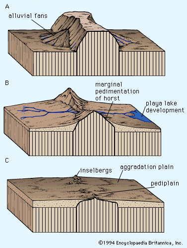
What role do playas play in the water cycle of arid regions?
In arid regions, playas serve as critical components of the water cycle by acting as terminal basins for internal drainage systems. When these depressions are periodically covered by water, they facilitate the movement of moisture through two primary pathways: evaporation into the atmosphere and infiltration into the groundwater system.51
The role of a playa in the water cycle is defined by the following processes:
- Water Collection: Playas receive water through occasional surface flood events or via groundwater flow. In basins dominated by surface runoff, floodwaters deposit fine-grained sediments like silt and clay, while the subsequent evaporation of ponded water concentrates salts at the surface.51
- Hydrologic Regulation: In areas where groundwater inputs dominate, sediment influx is minimized, and the playa may remain moist as water flows toward the basin’s lowest point. These moist zones are essential for maintaining the local hydrologic balance.5
- Climatic Indicators: Because they are highly sensitive to environmental changes, playas reflect past shifts in the hydrologic regimen. Historical expansions of these basins, often called pluvial lakes, provide evidence of past periods of increased rainfall or decreased evaporation.2
What types of minerals are commonly found in playa deposits?
Playa deposits are characterized by a complex variety of minerals that form as brines evaporate in arid, enclosed basins. These minerals are often zoned in “bathtub rings” based on their solubility, with less-soluble minerals forming at the outer margins and highly soluble ones concentrating in the center.9
Common minerals found in these deposits include:
- Carbonates: Calcite, dolomite, magnesite, aragonite, and sodium carbonateagonite, and sodium carbonate.9
- Sulfates: Gypsum, anhydrite, and thenardite.109
- Chlorides: Halite (table salt), sylvite, and carnallite.109
- Exotic Minerals: Some playas, such as those in Death Valley, are known for borate minerals like borax and meyerhofferite.9
The specific mineralogy of a playa reflects its unique depositional environment and climatic history. In addition to these salts, playa surfaces frequently contain clay minerals, such as smectite, which contribute to the formation of desiccation cracks and polygonal structures as the basin dries.23
What is a playa in geology?
A playa is a flat-bottomed, dry depression located within interior desert basins or near coasts in arid and semiarid regions. These landforms are among the flattest on Earth, with slopes often measuring less than 0.2 meters per kilometer.1
Playas function as terminal basins for internal drainage systems. They are periodically covered by water, which then either evaporates into the atmosphere or infiltrates into the groundwater system. This cycle of inundation and drying leads to the deposition of salt, sand, and mud. When a playa is temporarily filled with water, it is referred to as a playa lake.12
These basins can form through various geological processes, including tectonic activity like faulting and warping, as well as wind deflation or local drainage disruptions. Depending on their composition and regional naming conventions, they may also be known as salt flats, salt marshes, or dry lake beds.31
Sources
- playa — Encyclopædia Britannica
- playa - Physical characteristics — Encyclopædia Britannica
- playa - Surface relief and structures — Encyclopædia Britannica
- playa lake — Merriam-Webster
- playa - Role of flooding and groundwater — Encyclopædia Britannica
- playa — Merriam-Webster
- playa - Impact of climatic change — Encyclopædia Britannica
- arroyo — Encyclopædia Britannica
- sedimentary rock - Evaporites — Encyclopædia Britannica
- playa - Saline minerals — Encyclopædia Britannica
Published on · 3 min read