Polochic River
The Polochic River is a river located in eastern Guatemala. Its headstreams originate in the Chamá and Minas mountain ranges, and the river flows eastward…
What is Polochic River?
The Polochic River is a river located in eastern Guatemala. Its headstreams originate in the Chamá and Minas mountain ranges, and the river flows eastward for 150 miles (240 km) before forming a delta in Lake Izabal.12
The river is navigable as far upstream as Panzós, serving as a transport route primarily for coffee and lumber. While an unpaved highway follows the Polochic Valley, the region has seen limited development, with the exception of an unsuccessful nickel mining project in the late 1970s.1
What is the importance of Lake Izabal to Guatemala’s geography?
Lake Izabal is the largest lake in Guatemala, serving as a vital geographical feature in the country’s northeastern lowlands. Situated between the Santa Cruz, Minas, and San Isidro mountain ranges, it functions as a critical hydrological hub, receiving water from the Polochic River and draining into the Caribbean Sea via the Dulce River and Amatique Bay.3
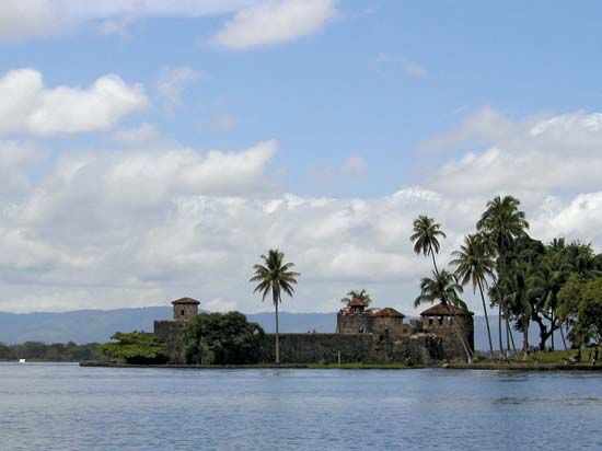
Beyond its physical geography, the lake has historically been a significant center for trade and defense. During the colonial era, it served as an essential export route for highland products, protected by the historic San Felipe fort. The region also hosts El Estor, a settlement that originated as a trading outpost for the United Fruit Company. Today, the area remains economically relevant due to its proximity to natural resources, including nickel mining operations.3
How do rivers like the Polochic and Chixoy shape the landscape of Guatemala?
Rivers in Guatemala act as primary agents of landscape formation, carving through the country’s complex topography to connect its highlands to the sea.
The Chixoy River plays a significant role in the northern drainage system. Rising in the Altos Cuchumatanes, it meanders through the central highlands, separating various regions before joining the Pasión River to form the Usumacinta River. This massive river system drains the northern sierras and flows toward the Gulf of Mexico, shaping the lowlands of the Petén and the borderlands with Mexico.25
In contrast, the Polochic River flows through the deep valleys that separate the eastern sierras, such as the Sierra de las Minas and the Sierra de Santa Cruz. These valleys serve as critical corridors that open eastward toward the Caribbean shoreline, facilitating drainage and transport. While the volcanic highlands to the south are defined by seismic activity and ash-filled basins, these northern and eastern river systems are essential for managing the country’s water flow, supporting regional agriculture, and providing historical routes for trade and communication.675
What role did the United Fruit Company play in the history of the region?
The United Fruit Company exerted profound influence over the history of Guatemala and other Latin American nations, often acting as a de facto ruler that prioritized corporate profit over national sovereignty. By the mid-20th century, the company controlled more than 40 percent of Guatemala’s arable land, creating an economy heavily dependent on a single commodity and fostering extreme social inequality.89
The company’s interests directly clashed with the reformist government of Jacobo Árbenz, who sought to modernize the economy and redistribute uncultivated land to landless workers. Fearing these reforms and labeling them as communist, the company leveraged its influence to help trigger the 1954 CIA-led Operation PBSUCCESS, which ousted Árbenz. This intervention dismantled democratic institutions, installed military rule, and contributed to a prolonged civil conflict that lasted until 1996, resulting in widespread human rights abuses.89
Beyond politics, the company established infrastructure such as the trading outpost of El Estor on Lake Izabal, cementing its role in the region’s economic landscape. The legacy of this era persists in the form of deep-seated economic inequality and poverty that continues to affect the region today.39
Sources
- Polochic River — Encyclopædia Britannica
- Chixoy River — Encyclopædia Britannica
- Lake Izabal — Encyclopædia Britannica
- Izabal, Lake — Merriam-Webster
- Guatemala - Drainage — Encyclopædia Britannica
- Guatemala - Relief — Encyclopædia Britannica
- Usumacinta River — Encyclopædia Britannica
- A History of U.S. Intervention in Latin America and the Caribbean - Guatemala: Overthrow by intervention — Encyclopædia Britannica
- banana republic — Encyclopædia Britannica
Published on · 3 min read