Qiangtang
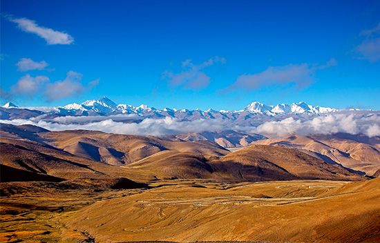
The Qiangtang is an enormous, high-altitude alpine basin located in the northern part of the Tibet Autonomous Region. Due to its extreme elevation, harsh…
What is the cultural significance of the Qiangtang Basin to the local Tibetan population?
The Qiangtang is an enormous, high-altitude alpine basin located in the northern part of the Tibet Autonomous Region. Due to its extreme elevation, harsh climate, and sterile, rocky landscape, the region is largely unsuitable for permanent settlement. Consequently, the area does not host major cultural institutions or urban centers, and there is no specific information in the provided records detailing a unique cultural significance attributed to the Qiangtang Basin itself by the local Tibetan population.
The region is primarily characterized by its sparse population of nomadic herders who inhabit the southern sections of the basin. While the broader Plateau of Tibet is central to Tibetan identity, religion, and history—with significant cultural life centered in regions like Dbus-Gtsang, Khams, and A-mdo—the Qiangtang remains a remote and inhospitable environment.12
How does the climate of the Qiangtang Basin affect its ecosystem and biodiversity?
The climate of the Qiangtang Basin is characterized by extreme cold, high winds, and aridity, which fundamentally restrict its ecosystem and biodiversity. With an average elevation exceeding 16,500 feet, the region experiences intense frost weathering that breaks down rock, resulting in a landscape dominated by sterile expanses of gravel and stone.1
The basin’s harsh environmental conditions significantly limit biological life:
- Vegetation: The northern reaches are largely a sterile rocky desert, while the slightly less arid southern sections support only sparse, hardy grasses, occasional shrubs, and limited juniper trees near water sources.1
- Water Constraints: The lack of perennial rivers and the presence of brackish salt lakes—remnants of larger ancient water bodies—further constrain the ecosystem. High evaporation rates and constant winds prevent the development of diverse aquatic or riparian habitats.1
- Fauna: While the broader Plateau of Tibet supports a variety of wildlife, including antelope, wild horses, wolves, foxes, bears, and snow leopards, the Qiangtang’s extreme climate and lack of dense vegetation make it a challenging environment for sustaining high levels of biodiversity compared to more temperate regions.17
What role does the Qiangtang Basin play in the water resources of the Tibetan Plateau?
The Qiangtang Basin functions primarily as a region of inland drainage rather than as a source for the major river systems that originate elsewhere on the Plateau of Tibet. Unlike the southern and eastern sections of the plateau, which serve as the headwaters for significant rivers such as the Indus, Brahmaputra, Yangtze, and Mekong, the Qiangtang is characterized by an absence of perennial rivers.1910
Instead of contributing to external water resources, the basin is defined by its internal drainage system. It contains numerous salt lakes, which are remnants of much larger ancient water bodies that have largely dried up due to the region’s arid climate, high evaporation rates, and constant winds. While the Nyainqêntanglha Mountains act as a watershed separating the river-fed valleys of southern Tibet from this area of inland drainage, the Qiangtang itself remains a sterile, high-altitude environment where water is largely trapped within its own basin.16
How has the elevation of the Qiangtang Basin influenced its development and accessibility?
The extreme elevation of the Qiangtang Basin, which averages over 16,500 feet (5,000 meters) above sea level, has rendered the region largely inaccessible and unsuitable for permanent human development. This high-altitude environment creates a cycle of intense frost weathering that breaks down rock, resulting in a landscape dominated by sterile, stony, and gravel-covered plains that are inhospitable to agriculture and infrastructure.1
The combination of this elevation and the basin’s remote, mountainous borders—including the Kunlun, Tanggula, and Nyainqêntanglha ranges—further isolates the area. The climate is characterized by extreme cold, high winds, and minimal precipitation, which prevents the development of permanent settlements. Consequently, the basin remains sparsely populated, with human presence limited to nomadic herders primarily in the slightly less arid southern sections.1
Sources
- Qiangtang — Encyclopædia Britannica
- Qinghai - Cultural life — Encyclopædia Britannica
- Qinghai - History of Qinghai — Encyclopædia Britannica
- Tibet - Population composition — Encyclopædia Britannica
- Tibet - Settlement patterns — Encyclopædia Britannica
- Plateau of Tibet — Encyclopædia Britannica
- Tibet - Climate of Tibet — Encyclopædia Britannica
- Qinghai - Land — Encyclopædia Britannica
- Tibet - Drainage and soils — Encyclopædia Britannica
- Nyainqêntanglha Mountains — Encyclopædia Britannica
Published on · 3 min read