Sepik River
The Sepik River contributes to the economy of Papua New Guinea primarily through its role in supporting local livelihoods. The river basin is characterized…
How does the Sepik River contribute to the economy of Papua New Guinea?
The Sepik River contributes to the economy of Papua New Guinea primarily through its role in supporting local livelihoods. The river basin is characterized by sago swamps, which are integral to the region’s subsistence farming practices. While the area is sparsely populated and lacks large-scale commercial settlements, the river serves as a vital transportation artery, navigable by canoe for approximately 550 miles, which facilitates local movement and trade.12
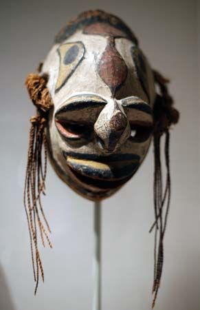
Furthermore, the river’s isolation has fostered the development of a unique and extensive artistic tradition known as the “Sepik River style.” This cultural heritage, which includes highly developed masks, sculptures, and decorated household or cult objects, represents a significant intangible economic and cultural asset for the region’s tribal groups. Unlike other areas of the country dominated by large-scale logging or export-oriented plantation crops, the Sepik basin remains largely defined by its traditional ecological and cultural systems.12
Where is the Sepik River located in New Guinea, and what is its geographical significance?
The Sepik River is located on the island of New Guinea in the southwestern Pacific Ocean. It originates in the Victor Emanuel Range of the central highlands of Papua New Guinea near Telefomin. The river flows northwestward into the Indonesian portion of the island before turning east to follow the Central Depression, eventually emptying into the Bismarck Sea.1
Geographically, the river is significant for its massive drainage basin, which covers approximately 30,000 square miles (77,700 square km). Its lower course is defined by a vast wilderness of sago and nipa palm swamps and lagoons filled with floating vegetation. The river carries a substantial amount of sediment, discoloring the ocean for 20 miles beyond its mouth, which spans over 1 mile in width. Navigability is a key feature, as the river can be traversed by shallow-draft vessels for over 300 miles and by canoe for roughly 550 miles.1
How have the indigenous peoples of the Sepik River region adapted to life along the river?
The indigenous peoples of the Sepik River region have adapted to their environment through specialized subsistence practices and unique social structures tailored to the river’s swampy landscape.
Subsistence and Environment
The lower Sepik basin is characterized by extensive sago and nipa palm swamps. The sago palm serves as a fundamental food source for these communities. Indigenous groups extract starchy pith from the trunks of these palms, which is then processed into a meal used for soups, puddings, and cakes. This reliance on sago allows populations to thrive in low-lying, marshy areas where other forms of agriculture may be difficult.14
Settlement and Social Organization
Adaptation is also reflected in settlement patterns. While many interior Melanesian groups historically lived in small, shifting hamlets, some Sepik communities formed large, permanent villages—occasionally exceeding 1,000 people—often situated near the river. These settlements frequently feature a distinct residential separation between genders:
- Domestic dwellings: Occupied by women and children.
- Cult houses: Large, high-gabled structures that serve as centers for ritual life, military solidarity, and the preservation of the region’s renowned artistic traditions.15
These cult houses and the surrounding artistic culture, which includes intricate wood carvings and masks, highlight the deep connection between the people and their environment.1
What are the unique ecological features of the Sepik River and its surrounding area?
The Sepik River and its surrounding basin possess a distinct ecological character shaped by high sediment loads, extensive wetlands, and unique vegetation patterns.
Hydrology and Sedimentation
The river system is defined by its massive sediment transport, which results from high erosion rates in the mountainous interior. This sediment load is so significant that it creates vast swampy plains and deltas, and the river’s discharge discolors the Bismarck Sea for up to 20 miles beyond its mouth. The lower course of the river meanders slowly through a wilderness of lagoons and swamps, where large floating islands of vegetation are common.17
Flora and Fauna
The region is dominated by sago palm and nipa palm swamps, which thrive in the brackish, low-lying environment. In areas where drier conditions prevail, human activity—including agriculture and the burning of vegetation—has historically maintained a grassland environment. The broader New Guinea region, including these river valleys, is home to a diverse array of reptiles, marsupials, and crocodiles, contributing to an unparalleled biogeography.18
Sources
- Sepik River — Encyclopædia Britannica
- Papua New Guinea - Agriculture, forestry, and fishing — Encyclopædia Britannica
- Oceanic art and architecture - The Massim area — Encyclopædia Britannica
- sago — Encyclopædia Britannica
- Melanesian culture - Settlement patterns — Encyclopædia Britannica
- Palm - Economic importance — Encyclopædia Britannica
- Papua New Guinea - Plant and animal life — Encyclopædia Britannica
- Papua New Guinea - Drainage and soils — Encyclopædia Britannica
Published on · 3 min read