Submarine Gap
A "submarine gap" is a geological feature, not a military or political term. It refers to a steep-sided furrow that cuts transversely across a ridge or rise…
What is submarine gap?
A “submarine gap” is a geological feature, not a military or political term. It refers to a steep-sided furrow that cuts transversely across a ridge or rise on the ocean floor. These gaps typically feature a steeper slope than the abyssal plains they connect and often contain grooves known as interplain channels.
The presence of graded sediments within these channels suggests that turbidity currents—underwater flows of sediment-laden water—move through these gaps from higher to lower abyssal plains. These currents are responsible for transporting and depositing sedimentary material while simultaneously eroding the channels.
It is important to distinguish this geological term from the “missile gap,” a Cold War-era political perception that the United States trailed the Soviet Union in ballistic missile technology, which was later proven to be inaccurate.12
What are turbidity currents and how do they shape the ocean floor?
Turbidity currents are underwater density currents characterized by a high concentration of suspended sediments, which makes them denser than the surrounding seawater. These transient, short-lived phenomena are typically triggered when sediment accumulated on continental shelves becomes unstable due to events like underwater landslides or earthquakes.789
Shaping the Ocean Floor
Turbidity currents act as powerful geological agents that transport vast quantities of land-derived material from continental margins to the deep sea. Their role in shaping the ocean floor includes:109
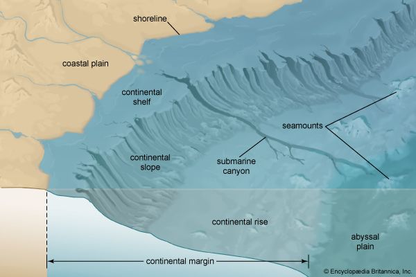
- Excavating Canyons: By eroding and transporting sediment, these currents are primary agents in the formation and maintenance of submarine canyons, which serve as conduits for material moving toward the deep ocean.10
- Building Submarine Fans: As these currents reach the base of a canyon and lose velocity, they deposit their sediment load. This repeated deposition creates submarine fans—large, fan-shaped accumulations of sand and silt that resemble alluvial fans found on land.7118
- Creating Turbidites: The sedimentary layers deposited by these currents are known as turbidites. These deposits are often characterized by a systematic grading of grain size, with coarser material at the bottom and finer particles at the top.79
Through these processes, turbidity currents redistribute enormous volumes of sediment, significantly influencing the topography of the continental rise and abyssal plains.119
How do submarine gaps differ from submarine canyons?
Submarine gaps and submarine canyons are both underwater features shaped by geological processes, but they differ significantly in their location, structure, and function.
Key Differences
Feature
Submarine Gap
Submarine Canyon
Location
Cuts transversely across a ridge or rise.
Cuts into continental slopes and continental rises.
Structure
A steep-sided furrow connecting two abyssal plains.
A narrow, steep-sided V-shaped valley.
Primary Function
Acts as a passageway for
turbidity currents
between abyssal plains.
Acts as a conduit for sediment transport from continental margins to the deep sea.
Distinct Characteristics
- Submarine Gaps: These are defined by their position crossing ridges or rises. They often contain “interplain channels” with graded sediments, which indicate that turbidity currents flow through them from higher to lower abyssal plains, eroding the channels as they pass.3
- Submarine Canyons: These are much more extensive features that often originate on the continental shelf or slope. While they also utilize turbidity currents for maintenance and sediment transport, they are frequently associated with the mouths of terrestrial rivers and can reach lengths exceeding 320 km. Their formation is often linked to a combination of subaerial erosion during lower sea levels and ongoing marine processes.87
What role do abyssal plains play in the formation of underwater features?
Abyssal plains are vast, flat areas of the seafloor that play a critical role in shaping underwater topography by acting as massive sediment traps. Located at depths between 3,000 and 6,000 meters, these plains smooth out preexisting irregular or hilly terrain through the accumulation of land-derived sediment, which can reach an average thickness of one kilometer.3
Their role in shaping the ocean floor includes:
- Smoothing Topography: By filling abyssal depressions with thick layers of sediment, these plains transform rugged, undulating landscapes into expansive, flat surfaces.3
- Sediment Deposition: They serve as the final destination for material transported by turbidity currents. These currents carry coarse materials—including sand, silt, and gravel—from continental margins, creating distinct, graded layers known as turbidites that interbed with fine-grained clays.3
- Facilitating Connectivity: Abyssal plains are often connected by submarine gaps, which act as conduits for turbidity currents to flow from higher to lower plains, further eroding and shaping the seafloor through the formation of interplain channels.14
Sources
- missile gap — Encyclopædia Britannica
- United States Navy - The U.S. Navy in the Cold War — Encyclopædia Britannica
- submarine gap — Encyclopædia Britannica
- submarine — Encyclopædia Britannica
- nuclear submarine - Design principles of nuclear submarines — Encyclopædia Britannica
- submarine - Design principles — Encyclopædia Britannica
- turbidity current — Encyclopædia Britannica
- submarine canyon — Encyclopædia Britannica
- submarine fan — Encyclopædia Britannica
- density current - Turbidity currents — Encyclopædia Britannica
- ocean basin - Sedimentation patterns — Encyclopædia Britannica
- marine sediment — Encyclopædia Britannica
- canyon — Encyclopædia Britannica
- abyssal plain — Encyclopædia Britannica
- abyssal plain — Merriam-Webster
Published on · 3 min read