What Is the Difference Between El Niño and La Niña?
El Niño and La Niña are opposite phases of the El Niño-Southern Oscillation (ENSO), a climate pattern driven by sea-surface temperature changes in the…
What Is the Difference Between El Niño and La Niña?
El Niño and La Niña are opposite phases of the El Niño-Southern Oscillation (ENSO), a climate pattern driven by sea-surface temperature changes in the equatorial Pacific Ocean.1
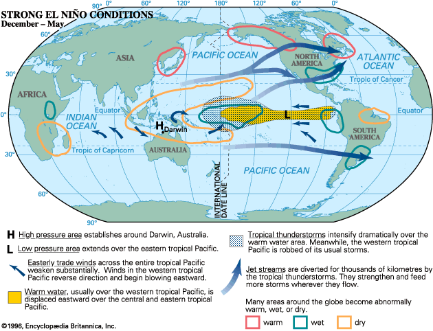
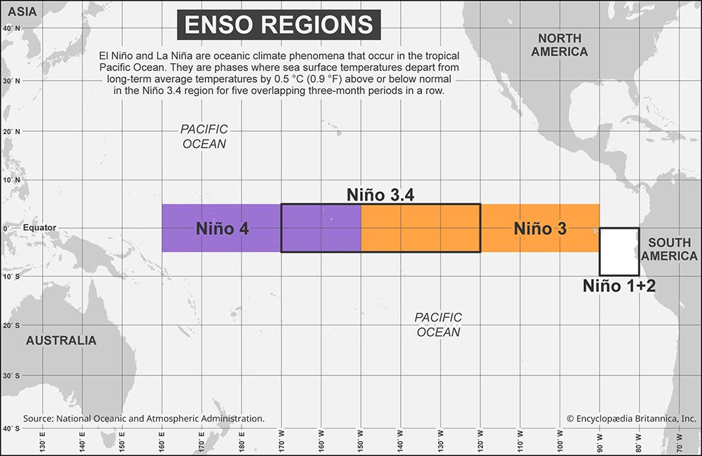
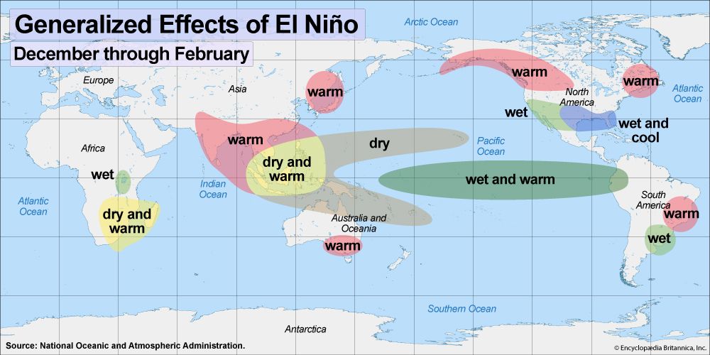
- El Niño (Warm Phase): Occurs when sea-surface temperatures in the central Pacific rise at least 0.5 °C above average for five consecutive three-month seasons. It is characterized by weakened trade winds, which reduce nutrient-rich upwelling along the South American coast, often leading to lower fish yields. It typically brings wetter conditions to western South America and drier conditions to Indonesia and northern Australia.12
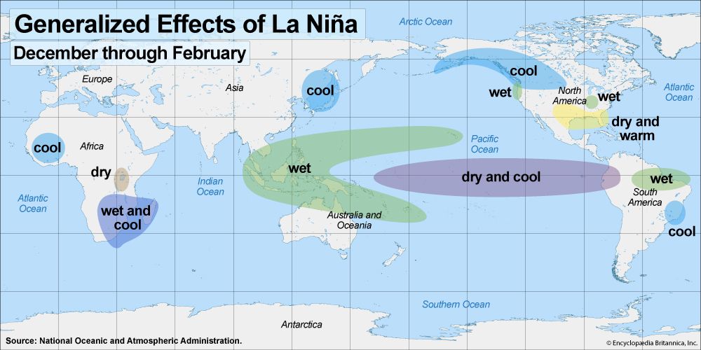
- La Niña (Cool Phase): Occurs when these temperatures drop at least 0.5 °C below average for the same duration. It features strengthened trade winds that enhance upwelling, supporting higher fish populations. It generally reverses El Niño’s effects, increasing rainfall in Indonesia and northern Australia while often causing cooler, wetter conditions in parts of North America and Africa.13
What is the process of upwelling and why is it important for marine life?
Upwelling is a physical process in the ocean where deep, cold, and typically nutrient-rich water is drawn upward to the surface. This movement is primarily driven by Ekman transport, where wind-driven surface currents move water away from a specific area—such as along a coastline or at divergence zones—creating a deficit that must be filled by water from below.56
This process is vital for marine life because it fuels the world’s most biologically productive ecosystems. The nutrients brought to the sunlit surface layer trigger the rapid reproduction of phytoplankton. These organisms form the base of the marine food web, supporting large populations of zooplankton and nekton, which in turn sustain some of the world’s most significant fisheries, such as those found off the coasts of Peru and California. When upwelling fails, the resulting lack of nutrients can lead to the collapse of these ecosystems and the industries that depend on them.75
How do scientists measure and track changes in Pacific Ocean temperatures?
Scientists monitor and track Pacific Ocean temperatures using a combination of remote sensing and direct, in-situ instrumentation to capture both surface and subsurface data.
Remote Sensing
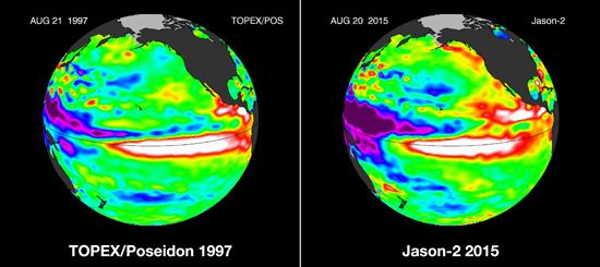
- Satellite Radiometers: Infrared and microwave radiometers measure radiant energy emitted from the sea surface to determine temperatures over vast areas, allowing for the monitoring of equatorial waves and current variations.8
- Radar Altimeters: By measuring the time it takes for radio pulses to travel to the sea surface and back, satellites can map sea-surface topography. This data helps oceanographers deduce pressure fields and circulation patterns, which are closely linked to temperature changes.89
In-Situ Measurements
- Floating Sensors and Buoys: Instruments such as Argo floats, along with sensors deployed from ships and aircraft, collect direct measurements of ocean heat content.9
- Acoustic Techniques: Inverted echo sounders on the seafloor measure the travel time of sound pulses to the surface. Because sound speed is affected by water temperature, fluctuations in travel time indicate changes in the average temperature of the water column.8
- Ocean Acoustic Tomography: Arrays of transmitters and receivers monitor sound pulse travel times to gather large-scale data on oceanic properties efficiently.8
These methods are essential for tracking phenomena like the Oceanic Niño Index, which identifies temperature anomalies in the east-central Pacific.10
What are trade winds and how do they influence global climate patterns?
Trade winds are persistent, prevailing winds that blow westward and toward the Equator from subtropical high-pressure belts toward the intertropical convergence zone (ITCZ)](https://www.britannica.com/science/intertropical-convergence-zone) (ITCZ). Originating between latitudes 30° and 40° N and S, these winds are most consistent over the oceans, where they maintain an average speed of about 5 to 6 meters per second.14113
These winds are fundamental to global climate patterns, particularly through their role in the El Niño-Southern Oscillation (ENSO) system. By pushing warm surface water westward, trade winds facilitate upwelling, which brings nutrient-rich deep water to the surface and supports marine ecosystems.15
The influence of trade winds on climate includes:
- ENSO Dynamics: During El Niño, trade winds weaken, reducing upwelling and shifting rainfall patterns, which leads to warmer, wetter conditions in parts of South America and drier conditions in Indonesia. Conversely, La Niña strengthens these winds, increasing upwelling and altering global precipitation and temperature trends.15
- Atmospheric Circulation: As part of the broader atmospheric circulation, trade winds help regulate heat distribution across the planet.1
- Local Weather: They typically produce fair weather with light, broken cumulus clouds, though they can also cause fog and low clouds along western continental coasts where they interact with cold upwelled water.1314
Sources
- What Is the Difference Between El Niño and La Niña? — Encyclopædia Britannica
- La Niña — Encyclopædia Britannica
- El Niño: Top Questions — Encyclopædia Britannica
- Southern Oscillation: Top Questions — Encyclopædia Britannica
- Marine ecosystem - Upwelling — Encyclopædia Britannica
- ocean current - Ekman layer — Encyclopædia Britannica
- upwelling — Merriam-Webster
- undersea exploration - Acoustic and satellite sensing — Encyclopædia Britannica
- ocean warming: Top Questions — Encyclopædia Britannica
- hydrologic sciences - Remote sensing of the oceans — Encyclopædia Britannica
- Pacific Ocean - Temperature — Encyclopædia Britannica
- Climate - The Southern Oscillation — Encyclopædia Britannica
- Pacific Ocean - The trade winds — Encyclopædia Britannica
- Trade wind — Encyclopædia Britannica
- Atmospheric circulation — Encyclopædia Britannica
Published on · 4 min read