Tequendama Falls
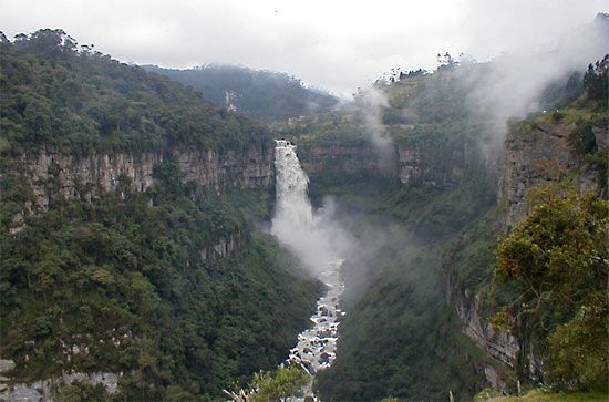
Tequendama Falls is a prominent waterfall located in the Andean Cordillera Oriental of central Colombia. Situated on the Bogotá (Funza) River—a tributary of…
What is Tequendama Falls?
Tequendama Falls is a prominent waterfall located in the Andean Cordillera Oriental of central Colombia. Situated on the Bogotá (Funza) River—a tributary of the Magdalena River—the falls are found in a forested region approximately 20 miles (32 km) west of the city of Bogotá.1
The geography of the site is defined by a rocky gorge that constricts to about 60 feet (18 meters) in width at the brink, where the water plunges 515 feet (157 meters) downward. As a major tourist attraction, the falls are accessible by road from the capital. Historically, the site was also known as a common location for suicides.1
What is the significance of the Bogota River in Colombia?
The Bogotá River, also known as the Funza River, is a significant waterway in central Colombia that flows through the Andean Cordillera Oriental. Its primary significance includes:1
- Geographical Landmark: The river is home to the Tequendama Falls, a major tourist attraction located in a forested area about 20 miles (32 km) west of Bogotá.1
- Hydrological Role: It serves as a tributary to the Magdalena River, which is a vital artery in Colombia’s geography and history.1
- Environmental Impact: While river fish are a traditional food source in Colombia, the stocks of these fish have been negatively impacted by pollution and siltation, issues that affect many of the nation’s waterways.3
The river is deeply connected to the region surrounding the capital, Bogotá, and its surrounding highlands, which are central to the country’s agricultural and cultural life.134
How do waterfalls form in mountainous regions?
Waterfalls in mountainous regions form through a variety of geological and structural processes that interrupt a river’s natural flow. While rivers typically work to smooth their gradients over time, mountainous terrain provides several conditions that create abrupt, vertical drops.6
Key factors include:
- Glaciation: This is a primary driver in many mountain ranges. Glaciers can carve out deep, main valleys, leaving tributary valleys “hanging” high above the valley floor. Once the ice melts, streams from these hanging valleys must tumble down to join the main drainage system. Additionally, glaciers can create “glacial stairways”—a series of steps in the bedrock—that result in cascades or waterfalls.67
- Tectonic Activity: Movements along faults can create fault scarps, which are steep cliffs that disrupt established drainage paths. As the land is uplifted, rivers may be forced to drop over these new vertical faces.67
- Differential Erosion: When a river flows from a layer of resistant rock to a softer one, it erodes the softer material more quickly, steepening the gradient at the junction.6
- Landform Morphology: Features like uplifted plateaus or steep canyon walls often force rivers to drop vertically, especially where springs issue from high up on canyon walls.67
What are some other famous natural landmarks in the Andes?
The Andes Mountains, which stretch 5,500 miles along the western edge of South America, are home to numerous spectacular natural landmarks. Beyond the peaks and valleys, the range features diverse geological and hydrological wonders:
- Mount Aconcagua: Located in Argentina, this is the highest peak in the Western Hemisphere, reaching an elevation of 22,831 feet (6,959 meters).89
- Lake Titicaca: Situated on the border of Peru and Bolivia, this is the largest lake in the central Andean region, located within the high-altitude Altiplano plateau.8
- Mount Huascarán: As the highest peak in Peru, this mountain is the namesake of the Blanca (White) Cordillera due to its prominent glaciated summit.8
- Volcanic Peaks: The Andes are part of the Ring of Fire, featuring many notable volcanoes such as Chimborazo in Ecuador and the Ruiz-Tolima complex in Colombia.81011
- Glacial Landscapes: The southern Andes are deeply carved by glaciers, containing massive ice fields and terminal tongues that feed into piedmont lakes.812
These landmarks are protected in various regions by national parks, such as Nahuel Huapí National Park in Argentina, which was a pioneer in wildlife conservation on the continent.13
Sources
- Tequendama Falls — Encyclopædia Britannica
- Tequendama Falls — Merriam-Webster
- Colombia - Transportation of Colombia — Encyclopædia Britannica
- Colombia - Agriculture, forestry, and fishing — Encyclopædia Britannica
- Colombia - Cultural origins — Encyclopædia Britannica
- waterfall — Encyclopædia Britannica
- river - Falls attributable to discordance of river profile — Encyclopædia Britannica
- South America - The Andes Mountains — Encyclopædia Britannica
- Andes Mountains - Geology — Encyclopædia Britannica
- South America - Human influences on wildlife — Encyclopædia Britannica
- Mount Aconcagua — Encyclopædia Britannica
- Andes Mountains - Physiography of the Southern Andes — Encyclopædia Britannica
- Andes Mountains - Physiography of the Northern Andes — Encyclopædia Britannica
- Aconcagua — Merriam-Webster
- Colombia - Relief — Encyclopædia Britannica
Published on · 3 min read