Thjórs River
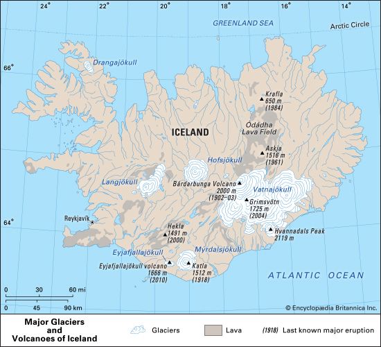
The Thjórs River (also spelled Thjórsá) is the longest river in Iceland. It originates in the central plateau northeast of the Hofsjökull glacier and flows…
What is Thjórs River?
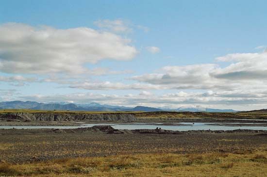
The Thjórs River (also spelled Thjórsá) is the longest river in Iceland. It originates in the central plateau northeast of the Hofsjökull glacier and flows southwest for 143 miles (230 km) before emptying into the Atlantic Ocean southeast of Selfoss.12
The river and its primary tributary, the Tungna, drain a basin of 2,907 square miles (7,530 square km), carrying meltwater from glaciers including Hofsjökull and Vatnajökull. The lower portion of this basin serves as the island’s most extensive agricultural region. Due to its significant size and strategic location in the densely populated southwest, the Thjórs River is the most productive source of hydroelectric power in the country.1
How is hydroelectric power generated from rivers?
Hydroelectric power is generated by converting the potential energy of water into mechanical energy and, ultimately, into electricity4.
The process typically involves the following steps:
- Collection: Water is impounded in a reservoir behind a dam, which raises the water to a higher elevation.3
- Conveyance: The water is directed downward through large pipes or tunnels known as penstocks. The vertical distance between the reservoir and the turbine is called the head4.
- Conversion: As the water reaches the bottom, its pressure and flow cause turbines to rotate. These turbines are connected to generators, which convert the mechanical rotation into electrical energy.3
- Transmission: Transformers increase the voltage of the generated electricity to make it suitable for long-distance transmission.3
While this process provides a clean, renewable energy source, it is essential to acknowledge the ethical and environmental costs. Large-scale dams can disrupt ecosystems, block the migration of fish, and force the displacement of human communities, necessitating a careful balance between energy needs and environmental stewardship.435
What are the largest glaciers in Iceland?
Iceland is home to five major ice caps, which are sustained by the island’s heavy snowfall. The largest of these is Vatnajökull (also known as Vatna Glacier), an extensive ice field in southeastern Iceland covering more than 3,000 square miles (approximately 8,400 square km). It features an average ice thickness exceeding 3,000 feet and contains Hvannadals Peak, the highest point in the country.78
Another significant ice field is Langjökull, located in west-central Iceland. It spans 395 square miles (1,025 square km) and reaches an elevation of 4,757 feet (1,450 metres) above sea level. These glaciers, along with others like Hofsjökull, play a vital role in the country’s hydrology by feeding numerous rivers, including the Thjórs River, which are essential for the nation’s hydroelectric power generation.9810
How do glaciers influence the landscape of Iceland?
Glaciers play a fundamental role in shaping the landscape of Iceland, covering approximately one-tenth of the country’s total area. Their influence is primarily seen through the following geological and hydrological processes:10
- Hydrological Impact: Glaciers are a primary source of water for Iceland’s numerous rivers and lakes. Meltwater from these ice caps feeds major river systems, such as the Thjórs River, which are essential for the nation’s hydroelectric power generation.118
- Erosion and Landforms: Glacial erosion has significantly sculpted the Icelandic terrain. In coastal regions, this process has deepened the inner portions of fjords, creating many natural harbors.11
- Jökulhlaups: Because many of Iceland’s glaciers bury active volcanoes, geothermal heat can create subglacial lakes. When these lakes break through their ice walls, they trigger catastrophic floods known as jökulhlaup (“glacier runs”), which can dramatically alter the surrounding landscape through rapid sediment transport and deposition.812
- Dammed Features: The interaction between glacial ice and volcanic activity is unique; many of Iceland’s lakes are formed by being dammed by either lava flows or glacial ice.11
Sources
- Thjórs River — Encyclopædia Britannica
- Hofsjökull — Encyclopædia Britannica
- Did you know? — Merriam-Webster
- hydroelectric power — Encyclopædia Britannica
- dam - Rise of environmental and economic concerns — Encyclopædia Britannica
- Yangtze River - Human impact on the environment — Encyclopædia Britannica
- Langjökull — Encyclopædia Britannica
- Vatnajökull — Encyclopædia Britannica
- Arctic - Other glacier groups — Encyclopædia Britannica
- Iceland - Lakes and rivers of Iceland — Encyclopædia Britannica
- Iceland - Land — Encyclopædia Britannica
- Quaternary - Landforms — Encyclopædia Britannica
- drumlin — Encyclopædia Britannica
- glacial landform - Meltwater deposits — Encyclopædia Britannica
- glacial landform - Glacial erosion — Encyclopædia Britannica
- iceberg - Impacts on ice sheets and sea level — Encyclopædia Britannica
Published on · 3 min read