La Niña
La Niña is the cool phase of the El Niño-Southern Oscillation (ENSO), a large-scale climate pattern occurring in the Pacific Ocean. It is defined by sea…
What is La Niña?
La Niña is the cool phase of the El Niño-Southern Oscillation (ENSO), a large-scale climate pattern occurring in the Pacific Ocean. It is defined by sea surface temperatures in the east-central Pacific (the Niño 3.4 region) dropping at least 0.5 °C (0.9 °F) below long-term averages for five or more consecutive three-month seasons.12
During a La Niña event, trade winds strengthen, pushing warm surface water toward equatorial Asia and Australia. This process enhances upwelling along the coast of South America, bringing nutrient-rich deep water to the surface, which supports increased populations of plankton and commercial fish.12
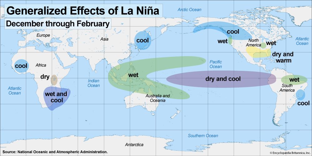
Globally, La Niña’s effects are complex and often opposite to those of El Niño. It is associated with increased precipitation in parts of North America and southeastern Africa, cooler conditions in northeast Asia, and heightened tropical cyclone activity in the North Atlantic.2
How does the El Niño-Southern Oscillation affect marine life?
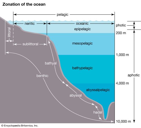
The El Niño-Southern Oscillation (ENSO) significantly impacts marine life by altering ocean circulation and nutrient availability, primarily through its influence on upwelling along the coast of South America.23
El Niño: The Warm Phase
During El Niño, weakened trade winds reduce the upwelling of cold, nutrient-rich deep water. This decline in nutrients causes plankton populations to drop, which in turn forces fish that rely on them—such as anchovies and sardines—to migrate away from traditional grounds. Historically, these events have led to drastic reductions in fish catches and have negatively impacted marine bird populations that depend on these fish for sustenance.23
La Niña: The Cool Phase
La Niña typically produces the opposite effect. Stronger trade winds enhance upwelling, bringing a greater abundance of nutrients to the surface. This surge in nutrients supports larger populations of plankton and fish, often resulting in higher yields for commercial fishing operations.21
What is the role of trade winds in global climate patterns?
Trade winds are persistent, westward-blowing winds that flow from subtropical high-pressure belts toward the intertropical convergence zone (ITCZ) near the Equator. These winds are a fundamental component of the Hadley cell, a direct heat engine that circulates air globally, transporting heat from the tropics toward higher latitudes.789
The role of trade winds in global climate patterns includes:
- Ocean Circulation: Trade winds drive major ocean currents by dragging surface water across the sea. This movement influences heat distribution and can affect weather patterns globally, such as the Gulf Stream in the Atlantic.10
- Upwelling: By pushing surface water away from coasts, trade winds stimulate the upwelling of cold, nutrient-rich deep water, which is vital for marine productivity.11
- ENSO Dynamics: The El Niño-Southern Oscillation (ENSO) is driven by fluctuations in trade wind strength. During El Niño, weakened winds reduce upwelling and alter global precipitation, while La Niña strengthens these winds, intensifying upwelling and shifting climate patterns.1011
- Moisture Transport: As trade winds move equatorward, they gather moisture, contributing to the formation of clouds and precipitation, particularly near the ITCZ.82
How do scientists measure and forecast these climate phases?
Scientists measure and forecast the El Niño-Southern Oscillation (ENSO) by monitoring key atmospheric and oceanic indicators that reflect the complex interactions between the sea and the air.131
Measuring Climate Phases
- Southern Oscillation Index (SOI): This index tracks the atmospheric component of ENSO by measuring the difference in atmospheric pressure between the western tropical Pacific (e.g., Darwin, Australia) and the eastern South Pacific. Negative SOI values indicate the “low phase” associated with El Niño, while positive values signify the “high phase” linked to La Niña.1314
- Oceanic Niño Index (ONI): This is the standard metric for identifying and gauging ENSO episodes. It measures departures from normal sea surface temperatures in the east-central Pacific. An episode is typically confirmed when temperatures deviate by more than 0.5 °C (0.9 °F) for at least five consecutive overlapping three-month seasons.15
Forecasting Methods
Forecasters utilize numerical weather prediction models that integrate global data from meteorological satellites, aircraft, and ocean-based sensors. Because ENSO features change slowly and follow somewhat regular patterns, scientists can use these interconnections to make long-range predictions. Researchers also study prehistoric records from tree rings, sediments, and corals to reconstruct past variations and improve the accuracy of future climate projections.16113
Sources
- La Niña — Encyclopædia Britannica
- What Is the Difference Between El Niño and La Niña? — Encyclopædia Britannica
- Climate - The El Niño phenomenon — Encyclopædia Britannica
- Southern Oscillation: Top Questions — Encyclopædia Britannica
- Southern Oscillation — Merriam-Webster
- Marine ecosystem - Migrations of marine organisms — Encyclopædia Britannica
- Trade wind — Encyclopædia Britannica
- Atmosphere - Convection , circulation, and deflection of air — Encyclopædia Britannica
- Wind — Encyclopædia Britannica
- Climate - Circulation, currents, and ocean-atmosphere interaction — Encyclopædia Britannica
- Pacific Ocean - The trade winds — Encyclopædia Britannica
- Climate - Zonal surface winds — Encyclopædia Britannica
- Climate - The Southern Oscillation — Encyclopædia Britannica
- Weather forecasting - Meteorological measurements from satellites and aircraft — Encyclopædia Britannica
- Weather forecasting - Prospects for new procedures — Encyclopædia Britannica
- Southern Oscillation — Encyclopædia Britannica
Published on · 3 min read